List of listed buildings in Longside, Aberdeenshire
List
| Name | Location | Date Listed | Grid Ref. [note 1] | Geo-coordinates | Notes | LB Number [note 2] | Image |
|---|---|---|---|---|---|---|---|
| 50 South Street | 57°31′19″N 2°00′01″W | Category C(S) | 9430 |  Upload Photo | |||
| Bridge Of Rora | 57°32′02″N 1°55′54″W | Category B | 9422 | Upload Photo | |||
| Glenugie Bridge Over South Ugie Water | 57°31′15″N 1°57′19″W | Category C(S) | 9424 | Upload Photo | |||
| Inverquhomery Steading | 57°30′31″N 1°58′00″W | Category B | 9425 | Upload Photo | |||
| Baluss Bridge Over South Ugie Water | 57°30′46″N 1°59′54″W | Category B | 9427 | Upload Photo | |||
| Old Parish Church Of Longside | 57°30′55″N 1°56′21″W | Category A | 9410 | 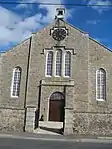
| |||
| Rowanlea, Main Street | 57°31′05″N 1°56′32″W | Category B | 9417 | Upload Photo | |||
| Inverquhomery, Group Of 3 Dovecots | 57°30′29″N 1°58′02″W | Category B | 9426 | Upload Photo | |||
| Dun-Na-Cluach (Former Manse Of Longside) | 57°30′50″N 1°56′29″W | Category C(S) | 9414 | Upload Photo | |||
| Churchyard Of Longside Parish Church | 57°30′56″N 1°56′21″W | Category C(S) | 9413 | Upload Photo | |||
| St. John's Episcopal Church, Longside | 57°30′53″N 1°56′05″W | Category B | 9419 | Upload Photo | |||
| Millbank House | 57°31′53″N 1°55′42″W | Category B | 9421 | Upload Photo | |||
| Mill Of Rora House | 57°32′15″N 1°55′55″W | Category B | 9423 | Upload Photo | |||
| 42, 44, 46 And 48 South Street | 57°31′19″N 2°00′01″W | Category C(S) | 9429 | Upload Photo | |||
| Duncan, Street Of Rora | 57°32′44″N 1°53′53″W | Category B | 9431 | Upload Photo | |||
| Bruce Arms Hotel, Main Street And Inn Brae | 57°31′01″N 1°56′22″W | Category C(S) | 9415 | Upload Photo | |||
| Viewfield, Inverquhomery Rd | 57°30′55″N 1°56′26″W | Category C(S) | 9418 | Upload Photo | |||
| Cairngall House And Garden Walls | 57°30′59″N 1°55′54″W | Category C(S) | 9420 | Upload Photo | |||
| Parish Church Of Longside | 57°30′56″N 1°56′21″W | Category B | 9411 | Upload Photo | |||
| Churchyard Gateway, Longside Parish Church | 57°30′56″N 1°56′21″W | Category A | 9412 | 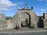
| |||
| Marshlands, Main Street | 57°31′03″N 1°56′24″W | Category B | 9416 | Upload Photo | |||
| Lambhillock, South Street | 57°31′25″N 2°00′01″W | Category C(S) | 9428 | Upload Photo |
Key
The scheme for classifying buildings in Scotland is:
- Category A: "buildings of national or international importance, either architectural or historic; or fine, little-altered examples of some particular period, style or building type."[1]
- Category B: "buildings of regional or more than local importance; or major examples of some particular period, style or building type, which may have been altered."[1]
- Category C: "buildings of local importance; lesser examples of any period, style, or building type, as originally constructed or moderately altered; and simple traditional buildings which group well with other listed buildings."[1]
In March 2016 there were 47,288 listed buildings in Scotland. Of these, 8% were Category A, and 50% were Category B, with the remaining 42% being Category C.[2]
Notes
- Sometimes known as OSGB36, the grid reference (where provided) is based on the British national grid reference system used by the Ordnance Survey.
• "Guide to National Grid". Ordnance Survey. Retrieved 12 December 2007.
• "Get-a-map". Ordnance Survey. Retrieved 17 December 2007. - Historic Environment Scotland assign a unique alphanumeric identifier to each designated site in Scotland, for listed buildings this always begins with "LB", for example "LB12345".
References
- All entries, addresses and coordinates are based on data from Historic Scotland. This data falls under the Open Government Licence
- "What is Listing?". Historic Environment Scotland. Retrieved 29 May 2018.
- Scotland's Historic Environment Audit 2016 (PDF). Historic Environment Scotland and the Built Environment Forum Scotland. pp. 15–16. Retrieved 29 May 2018.
This article is issued from Wikipedia. The text is licensed under Creative Commons - Attribution - Sharealike. Additional terms may apply for the media files.