List of listed buildings in Luss
List
| Name | Location | Date Listed | Grid Ref. [note 1] | Geo-coordinates | Notes | LB Number [note 2] | Image |
|---|---|---|---|---|---|---|---|
| Boiden | 56°02′18″N 4°38′28″W | Category C(S) | 43960 |  Upload Photo | |||
| Burnfoot | 56°01′40″N 4°37′57″W | Category C(S) | 43961 | Upload Photo | |||
| Gallowhill | 56°03′17″N 4°38′48″W | Category C(S) | 43967 | Upload Photo | |||
| Low Aldochlay, Rowanbank With Railings | 56°05′13″N 4°38′14″W | Category C(S) | 43972 | Upload Photo | |||
| Luss Village, The Bungalow Cleveland Bank | 56°06′05″N 4°38′14″W | Category B | 43976 | Upload Photo | |||
| Luss Village, Hall House And Luss Hall With Boundary Wall | 56°06′03″N 4°38′19″W | Category C(S) | 43980 | Upload Photo | |||
| Luss Village, Lochview and Pier Cottage With Boundary Wall | 56°06′07″N 4°38′15″W | Category B | 43981 | .jpg.webp)
| |||
| Port Of Rossdhu, Mill Bridge | 56°04′09″N 4°38′40″W | Category C(S) | 43990 | Upload Photo | |||
| Rossbank With Outbuildings | 56°01′42″N 4°38′33″W | Category B | 43993 | Upload Photo | |||
| Rossdhu Estate, Walled Garden With Glasshouses | 56°03′41″N 4°37′59″W | Category B | 43997 | Upload Photo | |||
| Shemore With Outbuildings | 56°03′37″N 4°39′31″W | Category B | 43998 | Upload Photo | |||
| Rossdhu Estate, South Lodge And Gate With Railings | 56°02′46″N 4°38′45″W | Category A | 19698 | 
| |||
| Luss Village, St Mackessog's Church (Church Of Scotland) With Burial Ground, Lych Gates And Boundary Wall | 56°06′01″N 4°38′12″W | Category B | 14430 | 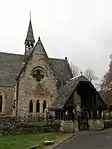
| |||
| Luss Village, Yewbank and Lonaigview | 56°06′06″N 4°38′16″W | Category B | 14433 | Upload Photo | |||
| Luss Village, Crescent Cottage | 56°06′04″N 4°38′19″W | Category B | 14446 | Upload Photo | |||
| Rossdhu Estate, Ross Lodge With Gatepiers And Railings | 56°03′27″N 4°38′43″W | Category B | 14455 | Upload Photo | |||
| High Aldochlay, 2 Roselea Cottages | 56°05′16″N 4°38′18″W | Category C(S) | 14460 | Upload Photo | |||
| Luss Village, Elmbank | 56°06′04″N 4°38′13″W | Category C(S) | 14466 | 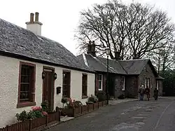
| |||
| Luss Village, Rose Cottage and The Sheiling | 56°06′04″N 4°38′17″W | Category B | 43982 | Upload Photo | |||
| Luss Village, Thistle Cottage | 56°06′08″N 4°38′15″W | Category C(S) | 43984 | .jpg.webp)
| |||
| Luss Village, War Memorial | 56°06′04″N 4°38′18″W | Category C(S) | 43986 | .jpg.webp)
| |||
| Ross Arden | 56°05′05″N 4°38′08″W | Category C(S) | 43992 | Upload Photo | |||
| Millburn Cottage And Mill | 56°06′00″N 4°38′37″W | Category B | 19700 | Upload Photo | |||
| Luss Village, Luss General Store | 56°06′07″N 4°38′15″W | Category C(S) | 14431 | Upload Photo | |||
| Auchentullich Namoin With Outbuildings | 56°02′19″N 4°38′42″W | Category C(S) | 43958 | Upload Photo | |||
| Bandry Cottages With Railings | 56°04′50″N 4°38′23″W | Category B | 43959 | Upload Photo | |||
| Camstradden House With Sundial, Boundary Wall And Gatepiers | 56°05′37″N 4°38′17″W | Category B | 43962 | Upload Photo | |||
| High Aldochlay, South Cottage And North Cottage | 56°05′16″N 4°38′17″W | Category B | 43969 | Upload Photo | |||
| Luss Village, Colquhoun Arms Hotel | 56°06′02″N 4°38′29″W | Category C(S) | 43978 | Upload Photo | |||
| Nether Ross | 56°01′53″N 4°38′16″W | Category C(S) | 43989 | Upload Photo | |||
| Rossdhu Estate, Dairy Dwelling | 56°03′32″N 4°37′59″W | Category C(S) | 43996 | Upload Photo | |||
| Luss Village, Avonlea and Ivy Bank | 56°06′05″N 4°38′16″W | Category B | 19697 | .jpg.webp)
| |||
| Luss Village, Mostyn Cottage | 56°06′05″N 4°38′17″W | Category B | 14435 | 
| |||
| Rossdhu Estate, Icehouse | 56°04′16″N 4°38′02″W | Category C(S) | 14450 | Upload Photo | |||
| Luss Village, The Anchorage And Lomondbank | 56°06′05″N 4°38′14″W | Category B | 14465 | 
| |||
| Glen Luss, Edentaggart Bridge | 56°06′38″N 4°41′36″W | Category C(S) | 14468 | Upload Photo | |||
| Rossdhu House With Walled Garden | 56°04′12″N 4°38′00″W | Category A | 14469 | 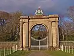
| |||
| Halfton Cottage | 56°05′46″N 4°38′30″W | Category C(S) | 43968 | Upload Photo | |||
| Luss Village, Church Of Scotland Manse With Boundary Wall | 56°06′03″N 4°38′14″W | Category C(S) | 43977 | Upload Photo | |||
| Luss Village, Shore Cottage | 56°06′03″N 4°38′10″W | Category C(S) | 43983 | 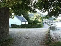
| |||
| Luss Village, Holly Cottage | 56°06′03″N 4°38′22″W | Category B | 14425 | Upload Photo | |||
| Luss Village, Tigh A Mhaoir | 56°06′04″N 4°38′21″W | Category B | 14426 | .jpg.webp)
| |||
| Luss Village, Fernlea and Ivy Cottage | 56°06′05″N 4°38′17″W | Category B | 14444 | Upload Photo | |||
| Low Aldochlay, Braeside With Gates And Railings | 56°05′12″N 4°38′14″W | Category B | 14459 | Upload Photo | |||
| Crosskeys Cottage | 56°01′49″N 4°40′06″W | Category C(S) | 43964 | Upload Photo | |||
| Low Aldochlay, Rose Cottage | 56°05′11″N 4°38′17″W | Category C(S) | 43971 | Upload Photo | |||
| Low Bridge | 56°02′08″N 4°38′24″W | Category B | 43975 | Upload Photo | |||
| Luss Village, Tighnafois | 56°06′04″N 4°38′12″W | Category C(S) | 43985 | Upload Photo | |||
| Muirland Cottage | 56°02′38″N 4°39′18″W | Category C(S) | 43987 | Upload Photo | |||
| Rossdhu Estate, Dairy Complex | 56°03′32″N 4°37′58″W | Category B | 43995 | Upload Photo | |||
| Bannachra Castle | 56°01′22″N 4°39′39″W | Category B | 19699 | Upload Photo | |||
| Luss Village, Sunnyside | 56°06′06″N 4°38′15″W | Category B | 14432 | 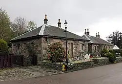
| |||
| Luss Village, Roselea | 56°06′04″N 4°38′18″W | Category B | 14445 | Upload Photo | |||
| Luss Village, Laurel Cottage and Ravenslea | 56°06′04″N 4°38′17″W | Category B | 14463 | Upload Photo | |||
| Glen Luss Chapel Memorial | 56°06′39″N 4°40′37″W | Category C(S) | 14464 | Upload Photo | |||
| Duchlage Farmhouse With Steading And Paddock Fencing | 56°02′54″N 4°39′02″W | Category C(S) | 43966 | Upload Photo | |||
| Low Aldochlay Cottage | 56°05′11″N 4°38′14″W | Category C(S) | 43973 | Upload Photo | |||
| Luss Village, Dell Cottage | 56°06′01″N 4°38′17″W | Category C(S) | 43979 | Upload Photo | |||
| Muirland School With Wall And Railings | 56°02′44″N 4°39′11″W | Category B | 43988 | Upload Photo | |||
| Luss Village, Lonaigbank and Marlyn | 56°06′06″N 4°38′16″W | Category B | 14434 | 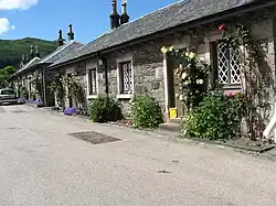
| |||
| Rossdhu Estate, St Mary's Chapel With Grave Monuments | 56°04′15″N 4°38′02″W | Category B | 14449 | Upload Photo | |||
| Culag Old Military Bridge | 56°08′15″N 4°39′36″W | Category C(S) | 14462 | Upload Photo | |||
| Glen Luss, Chapel Hill Bridge | 56°06′42″N 4°41′07″W | Category B | 14467 | Upload Photo | |||
| Ardallie | 56°05′17″N 4°38′30″W | Category C(S) | 43957 | Upload Photo | |||
| Carn Dearg | 56°06′09″N 4°38′33″W | Category C(S) | 43963 | Upload Photo | |||
| Inchgalbraith, Galbraith Castle | 56°04′40″N 4°37′19″W | Category C(S) | 43970 | Upload Photo | |||
| Low Aldochlay, Cottage | 56°05′11″N 4°38′14″W | Category C(S) | 43974 | Upload Photo | |||
| Rossdhu Estate, Coach House | 56°04′13″N 4°38′08″W | Category B | 43994 | Upload Photo | |||
| Springbank Cottage | 56°02′41″N 4°39′11″W | Category C(S) | 43999 | Upload Photo | |||
| Rossdhu Estate, Laundry | 56°04′14″N 4°38′07″W | Category B | 14452 | Upload Photo | |||
| Darroch Cottage | 56°05′48″N 4°38′40″W | Category C(S) | 43965 | Upload Photo | |||
| Port Of Rossdhu, Mill | 56°04′09″N 4°38′38″W | Category C(S) | 43991 | Upload Photo | |||
| Luss Village, Alderdale With Boundary Wall | 56°06′03″N 4°38′24″W | Category C(S) | 14447 | Upload Photo | |||
| Rossdhu Castle | 56°04′13″N 4°38′05″W | Category B | 14448 | Upload Photo | |||
| Rossdhu Lodge, North Lodge With Gatepiers And Railings | 56°04′24″N 4°38′20″W | Category B | 14454 | Upload Photo | |||
| Inverbeg Bridge | 56°08′43″N 4°39′58″W | Category C(S) | 49637 | Upload Photo |
Key
The scheme for classifying buildings in Scotland is:
- Category A: "buildings of national or international importance, either architectural or historic; or fine, little-altered examples of some particular period, style or building type."[2]
- Category B: "buildings of regional or more than local importance; or major examples of some particular period, style or building type, which may have been altered."[2]
- Category C: "buildings of local importance; lesser examples of any period, style, or building type, as originally constructed or moderately altered; and simple traditional buildings which group well with other listed buildings."[2]
In March 2016 there were 47,288 listed buildings in Scotland. Of these, 8% were Category A, and 50% were Category B, with the remaining 42% being Category C.[3]
Notes
- Sometimes known as OSGB36, the grid reference (where provided) is based on the British national grid reference system used by the Ordnance Survey.
• "Guide to National Grid". Ordnance Survey. Retrieved 12 December 2007.
• "Get-a-map". Ordnance Survey. Retrieved 17 December 2007. - Historic Environment Scotland assign a unique alphanumeric identifier to each designated site in Scotland, for listed buildings this always begins with "LB", for example "LB12345".
References
- All entries, addresses and coordinates are based on data from Historic Scotland. This data falls under the Open Government Licence
- LUSS OUTSTANDING CONSERVATION AREA APPRAISAL – Loch Lomond and the Trossachs National Park
- "What is Listing?". Historic Environment Scotland. Retrieved 29 May 2018.
- Scotland's Historic Environment Audit 2016 (PDF). Historic Environment Scotland and the Built Environment Forum Scotland. pp. 15–16. Retrieved 29 May 2018.
This article is issued from Wikipedia. The text is licensed under Creative Commons - Attribution - Sharealike. Additional terms may apply for the media files.