List of listed buildings in Mauchline, East Ayrshire
List
| Name | Location | Date Listed | Grid Ref. [note 1] | Geo-coordinates | Notes | LB Number [note 2] | Image |
|---|---|---|---|---|---|---|---|
| Nos. 2 And 4 Castle Street. (Jean Armour Burns' House And Museum) | 55°30′58″N 4°22′47″W | Category B | 14473 |  Upload Photo | |||
| East Mossgiel Farm | 55°31′36″N 4°23′40″W | Category B | 14480 | 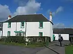
| |||
| Kingencleugh | 55°30′13″N 4°22′11″W | Category C(S) | 14482 | Upload Photo | |||
| Lodge And Gatepiers Rodinghead | 55°33′21″N 4°24′17″W | Category B | 14488 | Upload Photo | |||
| East Welton | 55°30′53″N 4°21′31″W | Category B | 19661 | Upload Photo | |||
| Lodge And Gatepiers Netherplace, New Road | 55°31′06″N 4°22′59″W | Category B | 19702 | Upload Photo | |||
| Mauchline Old Parish Church And Graveyard | 55°30′56″N 4°22′50″W | Category B | 14470 | 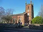
| |||
| Old Stables, Barskimming | 55°29′52″N 4°24′14″W | Category B | 14489 | Upload Photo | |||
| West Welton | 55°30′51″N 4°21′51″W | Category C(S) | 14491 | Upload Photo | |||
| Martyr's Grave | 55°31′01″N 4°22′33″W | Category B | 14477 | Upload Photo | |||
| Rodinghead | 55°33′23″N 4°24′23″W | Category B | 14486 | Upload Photo | |||
| Ballochmyle House, Ice House | 55°30′26″N 4°20′38″W | Category C(S) | 50609 | Upload Photo | |||
| Old Barskimming, Walled Garden | 55°29′50″N 4°24′10″W | Category C(S) | 19259 | Upload Photo | |||
| Nos 1-17 (Odd Numbers) Loudoun Street. (E. Bowie, Chemist) (William Bee, Druggist) (Lyall Stores), (Connell's Drapers) (N.M. Mcarvail, Cigarettes) | 55°30′56″N 4°22′46″W | Category B | 14475 | Upload Photo | |||
| Poosie Nansies | 55°30′56″N 4°22′47″W | Category B | 14476 | Upload Photo | |||
| Ballochmyle Railway Viaduct | 55°29′58″N 4°21′44″W | Category A | 14483 | 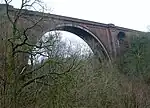
| |||
| Former Ballochmyle Creamery At Haugh Of Mauchline Including Garden Buildings And Egg-Ended Boiler | 55°29′56″N 4°22′58″W | Category B | 14492 | Upload Photo | |||
| Haughbank House At Former Ballochymyle Creamery, Haugh Of Mauchline | 55°29′56″N 4°22′57″W | Category C(S) | 14493 | Upload Photo | |||
| House In High Street (No. 3) | 55°30′58″N 4°22′45″W | Category B | 19701 | Upload Photo | |||
| Kingencleugh Castle | 55°30′06″N 4°22′15″W | Category B | 14481 | 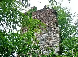
| |||
| Howford Bridge | 55°29′59″N 4°21′06″W | Category B | 14484 | Upload Photo | |||
| Mauchline Castle. (Abbot Hunter's Tower) | 55°30′57″N 4°22′51″W | Category A | 14471 | Upload Photo | |||
| Burns National Memorial And Cottage Homes | 55°31′19″N 4°23′17″W | Category B | 14479 | 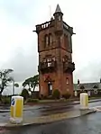
| |||
| Ballochmyle Bridge | 55°30′02″N 4°21′03″W | Category B | 14485 | Upload Photo | |||
| West Lodge | 55°30′32″N 4°21′24″W | Category C(S) | 19703 | Upload Photo | |||
| Auld Nanse Tinnock's Castle Street | 55°30′57″N 4°22′47″W | Category B | 14474 | Upload Photo | |||
| Gavin Hamilton's House | 55°30′57″N 4°22′51″W | Category B | 14472 | Upload Photo | |||
| Summerhouse, Springfield - (At Junction Of High Street And Welton Road) | 55°30′59″N 4°22′38″W | Category B | 14478 | Upload Photo | |||
| Ballochmyle House | 55°30′31″N 4°20′36″W | Category B | 14487 | .jpg.webp) |
Key
The scheme for classifying buildings in Scotland is:
- Category A: "buildings of national or international importance, either architectural or historic; or fine, little-altered examples of some particular period, style or building type."[1]
- Category B: "buildings of regional or more than local importance; or major examples of some particular period, style or building type, which may have been altered."[1]
- Category C: "buildings of local importance; lesser examples of any period, style, or building type, as originally constructed or moderately altered; and simple traditional buildings which group well with other listed buildings."[1]
In March 2016 there were 47,288 listed buildings in Scotland. Of these, 8% were Category A, and 50% were Category B, with the remaining 42% being Category C.[2]
Notes
- Sometimes known as OSGB36, the grid reference (where provided) is based on the British national grid reference system used by the Ordnance Survey.
• "Guide to National Grid". Ordnance Survey. Retrieved 12 December 2007.
• "Get-a-map". Ordnance Survey. Retrieved 17 December 2007. - Historic Environment Scotland assign a unique alphanumeric identifier to each designated site in Scotland, for listed buildings this always begins with "LB", for example "LB12345".
References
- All entries, addresses and coordinates are based on data from Historic Scotland. This data falls under the Open Government Licence
- "What is Listing?". Historic Environment Scotland. Retrieved 29 May 2018.
- Scotland's Historic Environment Audit 2016 (PDF). Historic Environment Scotland and the Built Environment Forum Scotland. pp. 15–16. Retrieved 29 May 2018.
This article is issued from Wikipedia. The text is licensed under Creative Commons - Attribution - Sharealike. Additional terms may apply for the media files.