List of listed buildings in Mearns, East Renfrewshire
List
| Name | Location | Date Listed | Grid Ref. [note 1] | Geo-coordinates | Notes | LB Number [note 2] | Image |
|---|---|---|---|---|---|---|---|
| Mearnskirk Hospital, Former Nurses' Home Administration Block Former Domestic Residence General Store House Lodge And Southfield House | 55°45′47″N 4°19′59″W | Category B | 19215 |  Upload Photo | |||
| Ayr Road, No 71 Newton Mearns | 55°47′01″N 4°18′48″W | Category B | 18526 | Upload Photo | |||
| Aurs Road, Balgray Reservoir Draw-Off Tower | 55°47′00″N 4°21′55″W | Category B | 51185 | Upload Photo | |||
| Robert Pollock Monument, At Junction Of Old Mearns Road With Ayr Road Near Loganswell | 55°44′37″N 4°21′54″W | Category C(S) | 19889 | 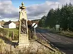
| |||
| Newton Mearns Broom Road East Kirkhill House | 55°46′29″N 4°18′14″W | Category B | 18524 | Upload Photo | |||
| Ayr Road, Fa'side House | 55°45′53″N 4°20′48″W | Category B | 18527 | Upload Photo | |||
| Church Of Maxwell, Mearns Castle, Broom Road, By Newton Mearns | 55°46′11″N 4°18′33″W | Category A | 18536 | 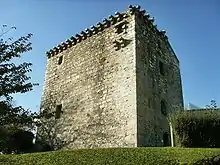
| |||
| "Croyland", No. 202 Ayr Road, Newton Mearns | 55°46′31″N 4°19′41″W | Category B | 18531 | Upload Photo | |||
| Balgray House, Off Stewarton Road (B769) | 55°46′46″N 4°22′22″W | Category B | 18533 | Upload Photo | |||
| "Holytree" (Formerly "Todhill"), Capelrig Road By Newton Mearns | 55°46′47″N 4°19′51″W | Category B | 18529 | Upload Photo | |||
| Humbie Road, Kirkhouse Newton Mearns | 55°46′00″N 4°19′21″W | Category B | 18534 | Upload Photo | |||
| Ayr Road, Gates And Gatepiers At No 71. Newton Mearns | 55°47′01″N 4°18′48″W | Category C(S) | 18525 | Upload Photo | |||
| Capelrig, Capelrig Road, By Newton Mearns | 55°47′12″N 4°19′36″W | Category A | 18523 | Upload Photo | |||
| Belmont House School, Formerly "Broom House", Sandringham Avenue, Newton Mearns | 55°46′53″N 4°18′48″W | Category B | 18528 | Upload Photo | |||
| Mearns Kirk, Mearnskirk Newton Mearns | 55°46′01″N 4°19′30″W | Category B | 18532 | 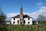 |
Key
The scheme for classifying buildings in Scotland is:
- Category A: "buildings of national or international importance, either architectural or historic; or fine, little-altered examples of some particular period, style or building type."[1]
- Category B: "buildings of regional or more than local importance; or major examples of some particular period, style or building type, which may have been altered."[1]
- Category C: "buildings of local importance; lesser examples of any period, style, or building type, as originally constructed or moderately altered; and simple traditional buildings which group well with other listed buildings."[1]
In March 2016 there were 47,288 listed buildings in Scotland. Of these, 8% were Category A, and 50% were Category B, with the remaining 42% being Category C.[2]
Notes
- Sometimes known as OSGB36, the grid reference (where provided) is based on the British national grid reference system used by the Ordnance Survey.
• "Guide to National Grid". Ordnance Survey. Retrieved 12 December 2007.
• "Get-a-map". Ordnance Survey. Retrieved 17 December 2007. - Historic Environment Scotland assign a unique alphanumeric identifier to each designated site in Scotland, for listed buildings this always begins with "LB", for example "LB12345".
References
- All entries, addresses and coordinates are based on data from Historic Scotland. This data falls under the Open Government Licence
- "What is Listing?". Historic Environment Scotland. Retrieved 29 May 2018.
- Scotland's Historic Environment Audit 2016 (PDF). Historic Environment Scotland and the Built Environment Forum Scotland. pp. 15–16. Retrieved 29 May 2018.
This article is issued from Wikipedia. The text is licensed under Creative Commons - Attribution - Sharealike. Additional terms may apply for the media files.