List of listed buildings in Morvern, Highland
List
| Name | Location | Date Listed | Grid Ref. [note 1] | Geo-coordinates | Notes | LB Number [note 2] | Image |
|---|---|---|---|---|---|---|---|
| Ardtornish Estate 1,2,3,4,5,6, Larachbeg | 56°34′12″N 5°45′15″W | Category B | 13961 |  Upload Photo | |||
| "Glenmorvern Cottage" And Walled Garden | 56°35′33″N 5°57′52″W | Category B | 13940 | Upload Photo | |||
| Laudale House | 56°40′35″N 5°40′33″W | Category C(S) | 13942 | Upload Photo | |||
| Lochaline, 1-5 (Inclusive Nos) High Street | 56°32′17″N 5°46′39″W | Category B | 13947 | Upload Photo | |||
| Ardtornish Estate, Beach House | 56°37′06″N 5°38′22″W | Category C(S) | 48287 | Upload Photo | |||
| Ardtornish Estate Castle Cottages | 56°33′46″N 5°45′00″W | Category B | 13955 | Upload Photo | |||
| Ardtornish Estate Larachbeg Old Laundry | 56°34′14″N 5°45′15″W | Category C(S) | 13962 | Upload Photo | |||
| Drimnin, St Columba's Roman Catholic Church | 56°37′20″N 5°59′57″W | Category B | 13938 | 
| |||
| Fiunary Old Manse (Former Church Of Scotland Manse) | 56°33′09″N 5°52′40″W | Category B | 13939 | Upload Photo | |||
| Killintag Burial Ground, Stewart Mausoleum | 56°36′45″N 5°58′14″W | Category B | 13941 | 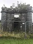
| |||
| By Lochaline, Keil House | 56°32′31″N 5°47′29″W | Category B | 13946 | Upload Photo | |||
| Ardtornish Estate Ardtornish Tower, Mansion And Clock Tower | 56°33′48″N 5°44′23″W | Category A | 13951 | 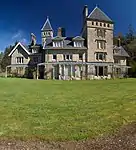
| |||
| Ardtornish Estate Bay Cottage, Inninbeg | 56°31′31″N 5°44′57″W | Category B | 13953 | 
| |||
| Ardtornish Estate Ferry House | 56°32′14″N 5°46′16″W | Category C(S) | 13954 | Upload Photo | |||
| Ardtornish Estate, Claggan School And Schoolhouse With Former Playground And Enclosing Walls | 56°34′58″N 5°44′54″W | Category B | 13956 | Upload Photo | |||
| Ardtornish Estate, (Old) Ardtornish Steading | 56°31′28″N 5°45′14″W | Category B | 13952 | Upload Photo | |||
| Ardtornish Estate Clounlaid | 56°36′28″N 5°40′03″W | Category B | 13957 | Upload Photo | |||
| Claggan Achadh Nan Gamhna Bridge Over River Aline | 56°34′56″N 5°45′05″W | Category C(S) | 13964 | Upload Photo | |||
| By Lochaline Keil Church Of Scotland, Session House And Walled Enclosure | 56°32′26″N 5°47′23″W | Category C(S) | 13944 | Upload Photo | |||
| By Lochaline, Keil Church Burial Ground And Remains Of Medieval Church | 56°32′24″N 5°47′27″W | Category B | 13945 | Upload Photo | |||
| Laudale Estate, Achleek House | 56°40′47″N 5°36′16″W | Category B | 48088 | Upload Photo | |||
| Ardtornish Estate Old Boathouse | 56°33′40″N 5°44′38″W | Category B | 13963 | 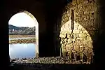
| |||
| Ardtornish Estate Achranich Manager's House And Estate Office | 56°33′42″N 5°44′17″W | Category B | 13949 | 
| |||
| Drimnin Estate, Dorlin Cottage | 56°39′25″N 5°54′21″W | Category B | 48288 | Upload Photo | |||
| Ardtornish Estate Kinlochaline Castle | 56°33′51″N 5°44′56″W | Category B | 13960 | 
| |||
| Ardtornish Estate Acharn Farmhouse | 56°35′22″N 5°44′45″W | Category C(S) | 13948 | Upload Photo | |||
| Drimnin, Mungasdale House | 56°36′43″N 5°57′56″W | Category C(S) | 48080 | Upload Photo | |||
| Ardtornish Estate, Rose Cottage | 56°33′57″N 5°44′53″W | Category C(S) | 19880 | 
| |||
| Ardtornish Estate Durinemast | 56°36′11″N 5°47′50″W | Category B | 13958 | Upload Photo | |||
| By Lochaline Achnaha Cottages And Steading | 56°32′34″N 5°49′58″W | Category B | 13943 | Upload Photo | |||
| Ardtornish Estate Achranich Smith's Barn | 56°33′42″N 5°44′13″W | Category C(S) | 13950 | Upload Photo | |||
| Ardtonish Estate, Single Cable Suspension Bridge | 56°35′11″N 5°44′55″W | Category B | 50848 | Upload Photo | |||
| Ardtornish Estate The Ivy Bridge Over River Aline | 56°33′51″N 5°44′53″W | Category B | 13959 | Upload Photo |
Key
The scheme for classifying buildings in Scotland is:
- Category A: "buildings of national or international importance, either architectural or historic; or fine, little-altered examples of some particular period, style or building type."[1]
- Category B: "buildings of regional or more than local importance; or major examples of some particular period, style or building type, which may have been altered."[1]
- Category C: "buildings of local importance; lesser examples of any period, style, or building type, as originally constructed or moderately altered; and simple traditional buildings which group well with other listed buildings."[1]
In March 2016 there were 47,288 listed buildings in Scotland. Of these, 8% were Category A, and 50% were Category B, with the remaining 42% being Category C.[2]
See also
Notes
- Sometimes known as OSGB36, the grid reference (where provided) is based on the British national grid reference system used by the Ordnance Survey.
• "Guide to National Grid". Ordnance Survey. Retrieved 12 December 2007.
• "Get-a-map". Ordnance Survey. Retrieved 17 December 2007. - Historic Environment Scotland assign a unique alphanumeric identifier to each designated site in Scotland, for listed buildings this always begins with "LB", for example "LB12345".
References
- All entries, addresses and coordinates are based on data from Historic Scotland. This data falls under the Open Government Licence
- "What is Listing?". Historic Environment Scotland. Retrieved 29 May 2018.
- Scotland's Historic Environment Audit 2016 (PDF). Historic Environment Scotland and the Built Environment Forum Scotland. pp. 15–16. Retrieved 29 May 2018.
This article is issued from Wikipedia. The text is licensed under Creative Commons - Attribution - Sharealike. Additional terms may apply for the media files.