List of listed buildings in Papa Westray, Orkney
List
| Name | Location | Date Listed | Grid Ref. [note 1] | Geo-coordinates | Notes | LB Number [note 2] | Image |
|---|---|---|---|---|---|---|---|
| Holland Farm Including Micklegarth, Well, Bothy And Dairy, Smithy And Joiners' Workshop, Stallion House, Threshing Barn And Horse Mill, Kiln And West Barn, Miller's House, Bothy, Byre, Cow Byre And Stackyard | 59°20′50″N 2°54′03″W | Category B | 18828 | 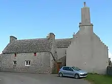
| |||
| Papa Westray War Memorial | 59°20′56″N 2°54′00″W | Category C(S) | 48101 | 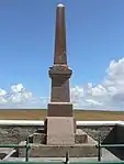
| |||
| Holland House, Including Adjoining Boundary Walls To East And South- West | 59°20′50″N 2°54′00″W | Category B | 18600 |  Upload Photo | |||
| Holland House, Pair Of Storehouses/Bothies To North -East | 59°20′50″N 2°53′59″W | Category B | 48095 | Upload Photo | |||
| Mid House | 59°21′30″N 2°53′13″W | Category C(S) | 48100 | Upload Photo | |||
| Kirkhouse Cottage | 59°21′24″N 2°53′42″W | Category C(S) | 48098 | 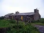
| |||
| Holland House, Walled Garden To East | 59°20′50″N 2°53′56″W | Category C(S) | 48096 | Upload Photo | |||
| Nouster Stores Including Pier | 59°21′02″N 2°53′09″W | Category C(S) | 47378 | Upload Photo | |||
| St Boniface Kirk (Old Papa Westray Kirk) Including Kirkyard And Boundary Walls | 59°21′27″N 2°54′07″W | Category B | 18599 | 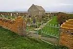
| |||
| The Manse, Including Garden Walls To South And East | 59°20′49″N 2°53′40″W | Category B | 48099 | Upload Photo | |||
| Holland Dovecot, To South West Of Holland Farm | 59°20′47″N 2°54′10″W | Category B | 18601 | 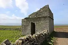
| |||
| Holland, Windmill Stump And Store | 59°20′41″N 2°53′54″W | Category C(S) | 48097 | Upload Photo |
Key
The scheme for classifying buildings in Scotland is:
- Category A: "buildings of national or international importance, either architectural or historic; or fine, little-altered examples of some particular period, style or building type."[1]
- Category B: "buildings of regional or more than local importance; or major examples of some particular period, style or building type, which may have been altered."[1]
- Category C: "buildings of local importance; lesser examples of any period, style, or building type, as originally constructed or moderately altered; and simple traditional buildings which group well with other listed buildings."[1]
In March 2016 there were 47,288 listed buildings in Scotland. Of these, 8% were Category A, and 50% were Category B, with the remaining 42% being Category C.[2]
See also
Notes
- Sometimes known as OSGB36, the grid reference (where provided) is based on the British national grid reference system used by the Ordnance Survey.
• "Guide to National Grid". Ordnance Survey. Retrieved 12 December 2007.
• "Get-a-map". Ordnance Survey. Retrieved 17 December 2007. - Historic Environment Scotland assign a unique alphanumeric identifier to each designated site in Scotland, for listed buildings this always begins with "LB", for example "LB12345".
References
- All entries, addresses and coordinates are based on data from Historic Scotland. This data falls under the Open Government Licence
- "What is Listing?". Historic Environment Scotland. Retrieved 29 May 2018.
- Scotland's Historic Environment Audit 2016 (PDF). Historic Environment Scotland and the Built Environment Forum Scotland. pp. 15–16. Retrieved 29 May 2018.
This article is issued from Wikipedia. The text is licensed under Creative Commons - Attribution - Sharealike. Additional terms may apply for the media files.