List of listed buildings in Penicuik, Midlothian
List
| Name | Location | Date Listed | Grid Ref. [note 1] | Geo-coordinates | Notes | LB Number [note 2] | Image |
|---|---|---|---|---|---|---|---|
| 39-49 (Odd Nos) John Street, Including Boundary Walls | 55°49′41″N 3°13′20″W | Category B | 43275 |  Upload Photo | |||
| St Kentigern's Kirkyard, Clerks Of Penicuik Mausoleum | 55°49′38″N 3°13′08″W | Category A | 39292 | 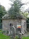
| |||
| Sun-Dial, Walled Garden, New Hall | 55°47′48″N 3°18′57″W | Category B | 14646 | Upload Photo | |||
| 15-23 (Odd Nos) High Street | 55°49′35″N 3°13′16″W | Category C(S) | 46817 | Upload Photo | |||
| 55 John Street, Including Boundary Walls And Gatepier | 55°49′43″N 3°13′21″W | Category C(S) | 46823 | Upload Photo | |||
| 68 John Street, Including Boundary Wall | 55°49′45″N 3°13′24″W | Category C(S) | 46824 | Upload Photo | |||
| 23 And 24 The Square | 55°49′33″N 3°13′19″W | Category C(S) | 46826 | Upload Photo | |||
| 1-5 (Odd Nos) West Street | 55°49′33″N 3°13′22″W | Category C(S) | 46827 | Upload Photo | |||
| 32 West Street, Former South Church Manse, Including Boundary Wall, Railings And Gates | 55°49′32″N 3°13′26″W | Category B | 46830 | Upload Photo | |||
| West Street, South Church Hall | 55°49′32″N 3°13′25″W | Category C(S) | 46831 | 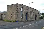
| |||
| High Street, St Mungo's Parish Church (Church Of Scotland), Including Hearse House, Churchyard, Boundary Walls, Gatepiers, Railings And Gates | 55°49′38″N 3°13′11″W | Category B | 39290 | 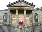
| |||
| Mosshouses Farmhouse And Farm Ranges | 55°47′51″N 3°12′35″W | Category C(S) | 19393 | Upload Photo | |||
| Gazebo. Old Walled Garden Penicuik Policies | 55°49′04″N 3°15′19″W | Category B | 14636 | Upload Photo | |||
| Brunstane Castle | 55°48′38″N 3°16′32″W | Category B | 14643 | Upload Photo | |||
| Habbie's Howe Inn Nine Mile Burn | 55°48′19″N 3°18′51″W | Category C(S) | 14660 | Upload Photo | |||
| 17 And 18 The Square | 55°49′32″N 3°13′18″W | Category C(S) | 46825 | Upload Photo | |||
| 22-34 (Even Nos) Bridge Street And 1-7 (Inclusive Nos) Park End, Including Archway | 55°49′29″N 3°13′18″W | Category A | 39294 | 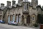
| |||
| High Street, Old Well (Cowan Well) | 55°49′34″N 3°13′20″W | Category B | 39299 | 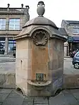
| |||
| Thomas Dunmore Memorial | 55°47′44″N 3°19′16″W | Category B | 19705 | Upload Photo | |||
| 27 Croft Street, 'The Old Schoolhouse' | 55°49′28″N 3°13′22″W | Category C(S) | 46813 | Upload Photo | |||
| 9 And 11 High Street | 55°49′34″N 3°13′18″W | Category C(S) | 46815 | Upload Photo | |||
| Broomhill Road, St James The Less Church (Episcopal), Including Churchyard And Boundary Walls | 55°49′29″N 3°13′39″W | Category B | 39296 | 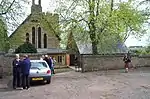
| |||
| 35 High Street, Glebe House, Including Pavilion Blocks, Boundary Walls And Bee Boles | 55°49′36″N 3°13′13″W | Category B | 39298 | Upload Photo | |||
| Old Howgate Inn | 55°48′37″N 3°12′04″W | Category B | 14641 | Upload Photo | |||
| 5 And 7 High Street | 55°49′34″N 3°13′18″W | Category B | 46814 | 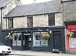
| |||
| 51 John Street, Including Boundary Walls | 55°49′42″N 3°13′21″W | Category C(S) | 46822 | Upload Photo | |||
| St Kentigern's Church, Kirkyard And Boundary Wall | 55°49′37″N 3°13′10″W | Category B | 39291 | 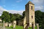
| |||
| Valleyfield, Sepulchral Monument | 55°49′36″N 3°13′06″W | Category B | 39293 | Upload Photo | |||
| Valleyfield Mill Site, Off Valleyfield Road, Mill Lade Cottage (Former Valleyfield School And Schoolhouse), Including Wall, Gate And Railings | 55°49′29″N 3°13′11″W | Category B | 39297 | 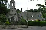
| |||
| Flag Tower, Knight's Law, Penicuik Policies | 55°49′26″N 3°14′48″W | Category B | 14638 | 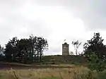
| |||
| Pomathorn Road, Uttershill House, Including Boundary Walls, Gates And Gatepiers | 55°49′20″N 3°13′01″W | Category B | 46282 | Upload Photo | |||
| 50 Bog Road, Craigiebield House Hotel | 55°49′39″N 3°13′40″W | Category B | 46807 | Upload Photo | |||
| 13 High Street, The Old Crown Inn | 55°49′34″N 3°13′17″W | Category C(S) | 46816 | 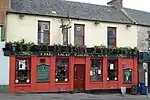
| |||
| 33-37 (Odd Nos) West Street, Including Boundary Walls, Gatepiers And Gates | 55°49′33″N 3°13′25″W | Category C(S) | 46828 | Upload Photo | |||
| 2-6 (Even Nos) West Street | 55°49′33″N 3°13′21″W | Category C(S) | 46829 | Upload Photo | |||
| Old Penicuik House | 55°49′11″N 3°15′03″W | Category A | 14634 | 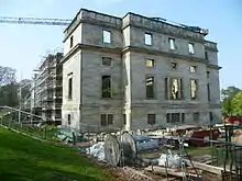
| |||
| Sophia Inglis Memorial, Wester Auchindinny | 55°50′35″N 3°11′46″W | Category C(S) | 14661 | Upload Photo | |||
| 24 Bog Road | 55°49′35″N 3°13′28″W | Category B | 46806 | Upload Photo | |||
| 12 High Street, The Railway Tavern | 55°49′35″N 3°13′21″W | Category C(S) | 46819 | Upload Photo | |||
| 34 High Street, The Royal Hotel | 55°49′36″N 3°13′16″W | Category C(S) | 46820 | Upload Photo | |||
| Peebles Road, Penicuik South Church (Church Of Scotland), Including Boundary Walls And Gatepiers | 55°49′22″N 3°13′17″W | Category A | 39295 | 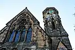
| |||
| New Penicuik House (Formerly Stables) | 55°49′16″N 3°15′05″W | Category A | 14635 | 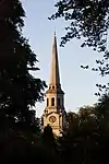
| |||
| Bridge, River North Esk Penicuik Policies | 55°49′04″N 3°14′49″W | Category B | 14637 | Upload Photo | |||
| Allan Ramsay Monument Penicuik Policies | 55°48′52″N 3°14′26″W | Category B | 14639 | Upload Photo | |||
| Uttershill Castle | 55°49′20″N 3°13′01″W | Category C(S) | 14640 | 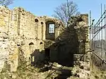
| |||
| 'Howgatemouth' Howgate | 55°48′35″N 3°12′05″W | Category C(S) | 14642 | Upload Photo | |||
| New Hall House | 55°47′44″N 3°19′03″W | Category B | 14644 | Upload Photo | |||
| Sun-Dial Front Garden, New Hall | 55°47′43″N 3°19′02″W | Category B | 14645 | Upload Photo | |||
| Charlotte Campbell Memorial House, Nine Mile Burn | 55°48′16″N 3°18′46″W | Category C(S) | 46424 | Upload Photo | |||
| 25 Bog Road, Navaar House Hotel | 55°49′33″N 3°13′31″W | Category B | 46805 | Upload Photo | |||
| 18 Bridge Street | 55°49′29″N 3°13′18″W | Category C(S) | 46808 | Upload Photo | |||
| 25 Croft Street, Including Boundary Walls | 55°49′27″N 3°13′23″W | Category B | 46812 | Upload Photo | |||
| 6-10 (Even Nos) High Street, Scotmid | 55°49′34″N 3°13′21″W | Category C(S) | 46818 | Upload Photo | |||
| High Street, Council Offices (Former Cowan Institute) | 55°49′35″N 3°13′14″W | Category C(S) | 46821 | 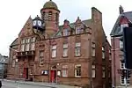
| |||
| 'Rustick Hut' Above Habbie's Howe | 55°47′40″N 3°19′14″W | Category B | 14647 | Upload Photo | |||
| 30 Cairnbank Road | 55°49′28″N 3°13′20″W | Category B | 46810 | Upload Photo | |||
| Carlops Road, Penicuik High School, Including Boundary Walls, Gatepiers And Gates | 55°49′52″N 3°13′43″W | Category B | 46811 | 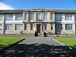 |
Key
The scheme for classifying buildings in Scotland is:
- Category A: "buildings of national or international importance, either architectural or historic; or fine, little-altered examples of some particular period, style or building type."[1]
- Category B: "buildings of regional or more than local importance; or major examples of some particular period, style or building type, which may have been altered."[1]
- Category C: "buildings of local importance; lesser examples of any period, style, or building type, as originally constructed or moderately altered; and simple traditional buildings which group well with other listed buildings."[1]
In March 2016 there were 47,288 listed buildings in Scotland. Of these, 8% were Category A, and 50% were Category B, with the remaining 42% being Category C.[2]
Notes
- Sometimes known as OSGB36, the grid reference (where provided) is based on the British national grid reference system used by the Ordnance Survey.
• "Guide to National Grid". Ordnance Survey. Retrieved 12 December 2007.
• "Get-a-map". Ordnance Survey. Retrieved 17 December 2007. - Historic Environment Scotland assign a unique alphanumeric identifier to each designated site in Scotland, for listed buildings this always begins with "LB", for example "LB12345".
References
- All entries, addresses and coordinates are based on data from Historic Scotland. This data falls under the Open Government Licence
- "What is Listing?". Historic Environment Scotland. Retrieved 29 May 2018.
- Scotland's Historic Environment Audit 2016 (PDF). Historic Environment Scotland and the Built Environment Forum Scotland. pp. 15–16. Retrieved 29 May 2018.
This article is issued from Wikipedia. The text is licensed under Creative Commons - Attribution - Sharealike. Additional terms may apply for the media files.