List of listed buildings in St Andrews And Deerness, Orkney
List
| Name | Location | Date Listed | Grid Ref. [note 1] | Geo-coordinates | Notes | LB Number [note 2] | Image |
|---|---|---|---|---|---|---|---|
| Hall Of Tankerness, Steading, Including Farmhouse, Barn And Smithy | 58°57′49″N 2°49′49″W | Category B | 18830 |  Upload Photo | |||
| Tankerness, Sebay Farmhouse, Including Boundary Wall And Steading | 58°56′07″N 2°49′50″W | Category C(S) | 18571 | Upload Photo | |||
| Copinsay Lighthouse, Including Foghorn And Keepers' Houses | 58°53′47″N 2°40′19″W | Category B | 18574 | 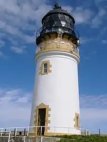
| |||
| Deerness, Braebuster, Including Farmhouse, Boundary Walls, Gatepiers, Steading, Kiln And Cottages | 58°55′59″N 2°47′39″W | Category C(S) | 46143 | Upload Photo | |||
| Deerness, Cellardyke, Including Dwelling House And Barn | 58°55′23″N 2°45′54″W | Category C(S) | 46144 | Upload Photo | |||
| Toab, Derbyshire | 58°55′03″N 2°48′18″W | Category B | 46154 | Upload Photo | |||
| Tankerness Meal Mill, Including Boundary Wall And Lade | 58°57′41″N 2°50′45″W | Category B | 18567 | Upload Photo | |||
| Hall Of Tankerness, St Andrew's Burial Ground, And Baikie Burial Vault | 58°57′51″N 2°49′50″W | Category B | 18570 | Upload Photo | |||
| Tankerness Fishing Station, Including Curing House, Salt Warehouse, Bothy And Pier | 58°57′44″N 2°49′55″W | Category B | 46151 | Upload Photo | |||
| Tankerness, (Linkness), The Ness, Including Threshing Barn And Wind Powered Water Pump | 58°58′09″N 2°47′44″W | Category C(S) | 46152 | Upload Photo | |||
| Tankerness, Old St Andrews Manse, Including Boundary Wall, Ancillary Building And Cottage | 58°57′47″N 2°50′36″W | Category B | 18568 | Upload Photo | |||
| Deerness, Mirkady Steading, Including Farmhouse And Horse Mill | 58°56′49″N 2°47′55″W | Category C(S) | 46147 | Upload Photo | |||
| Deerness, North House | 58°57′07″N 2°45′49″W | Category B | 46148 | Upload Photo | |||
| Deerness, Skaill, St Ninian's Church, (Church Of Scotland) Including Walled Churchyard And Railings | 58°56′33″N 2°43′01″W | Category B | 18572 | Upload Photo | |||
| Deerness, The Covenanter's Memorial | 58°57′46″N 2°44′54″W | Category B | 18573 | 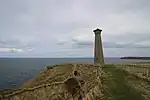
| |||
| Deerness, Bisgarth Manse | 58°55′55″N 2°43′07″W | Category B | 48328 | Upload Photo | |||
| Tankerness, Yinstay, Scarpigar Farm Buildings | 58°58′48″N 2°51′31″W | Category B | 46153 | Upload Photo | |||
| Tankerness, Sebay Meal Mill | 58°55′36″N 2°50′35″W | Category B | 19890 | Upload Photo | |||
| Tankerness, St Andrew's Kirk, (North Church), (Church Of Scotland) | 58°57′22″N 2°51′05″W | Category C(S) | 18566 | Upload Photo | |||
| Hall Of Tankerness, Including Boundary Walls And Gatepiers | 58°57′52″N 2°49′48″W | Category B | 18569 | Upload Photo | |||
| Canniemyre | 58°55′11″N 2°51′19″W | Category C(S) | 46142 | Upload Photo | |||
| Deerness, Mirkady Point, Mirkady Fishing Station | 58°56′47″N 2°48′20″W | Category B | 46146 | Upload Photo | |||
| Deerness, Quoypettie, Including Ancillary Structures | 58°56′31″N 2°44′32″W | Category C(S) | 46149 | Upload Photo | |||
| Deerness, Former School And Schoolhouse (Vinya Heim) Including Boundary Walls And Lavatory Block | 58°55′55″N 2°45′38″W | Category C(S) | 46150 | Upload Photo |
Key
The scheme for classifying buildings in Scotland is:
- Category A: "buildings of national or international importance, either architectural or historic; or fine, little-altered examples of some particular period, style or building type."[1]
- Category B: "buildings of regional or more than local importance; or major examples of some particular period, style or building type, which may have been altered."[1]
- Category C: "buildings of local importance; lesser examples of any period, style, or building type, as originally constructed or moderately altered; and simple traditional buildings which group well with other listed buildings."[1]
In March 2016 there were 47,288 listed buildings in Scotland. Of these, 8% were Category A, and 50% were Category B, with the remaining 42% being Category C.[2]
See also
Notes
- Sometimes known as OSGB36, the grid reference (where provided) is based on the British national grid reference system used by the Ordnance Survey.
• "Guide to National Grid". Ordnance Survey. Retrieved 12 December 2007.
• "Get-a-map". Ordnance Survey. Retrieved 17 December 2007. - Historic Environment Scotland assign a unique alphanumeric identifier to each designated site in Scotland, for listed buildings this always begins with "LB", for example "LB12345".
References
- All entries, addresses and coordinates are based on data from Historic Scotland. This data falls under the Open Government Licence
- "What is Listing?". Historic Environment Scotland. Retrieved 29 May 2018.
- Scotland's Historic Environment Audit 2016 (PDF). Historic Environment Scotland and the Built Environment Forum Scotland. pp. 15–16. Retrieved 29 May 2018.
This article is issued from Wikipedia. The text is licensed under Creative Commons - Attribution - Sharealike. Additional terms may apply for the media files.