List of listed buildings in Stornoway
List
| Name | Location | Date Listed | Grid Ref. [note 1] | Geo-coordinates | Notes | LB Number [note 2] | Image |
|---|---|---|---|---|---|---|---|
| 1, 3 Cromwell Street And 20 South Beach Thorlee Guest House | 58°12′29″N 6°23′16″W | Category C(S) | 41678 |  Upload Photo | |||
| 59-63 (Odd Nos) Cromwell Street and 1 Church Street Loch Erisort | 58°12′35″N 6°23′18″W | Category B | 41681 | 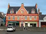
| |||
| 32-38 (Even Nos) Cromwell Street | 58°12′35″N 6°23′20″W | Category B | 41683 | Upload Photo | |||
| Francis Street, Museum (Formerly Free Church Seminary And School Building) | 58°12′34″N 6°22′59″W | Category B | 41689 | 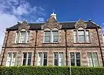
| |||
| 2 Goathill Crescent, Wandene Including Boundary Walls And Gatepiers | 58°12′43″N 6°22′54″W | Category B | 41691 | 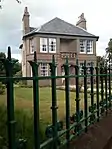
| |||
| 2 Goathill Road And Matheson Road, Including Boundary Walls Gates And Gatepiers | 58°12′41″N 6°22′57″W | Category B | 41692 | Upload Photo | |||
| 4, 6 Goathill Road Including Boundary Wall, Gates And Railings | 58°12′42″N 6°22′55″W | Category B | 41693 | 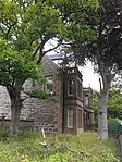
| |||
| 22, 24 James Street Bellevue House Including Boundary Walls Gates And Railings | 58°12′30″N 6°22′58″W | Category B | 41698 | Upload Photo | |||
| 26 And 27 James Street Including Boundary Walls, Gates And Railings | 58°12′30″N 6°22′57″W | Category B | 41699 | Upload Photo | |||
| 67-71 (Odd Nos) Kenneth Street | 58°12′40″N 6°23′17″W | Category C(S) | 41709 | Upload Photo | |||
| 3, 5 Matheson Road Including Boundary Walls, Gates And Gatespiers | 58°12′37″N 6°22′54″W | Category B | 41717 | Upload Photo | |||
| 9, 11 Matheson Road Including Boundary Walls, Gates And Railings | 58°12′38″N 6°22′55″W | Category B | 41719 | 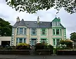
| |||
| 2 (Fasgadh), 4 (Brentor), Matheson Road Including Boundary Walls, Gates And Railings | 58°12′33″N 6°22′55″W | Category B | 41723 | 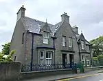
| |||
| 6, 7 North Beach | 58°12′30″N 6°23′28″W | Category B | 41733 | Upload Photo | |||
| North Beach Quay/North Beach Old Sail Loft And House Adjoining | 58°12′30″N 6°23′30″W | Category A | 41735 | 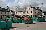
| |||
| 28, 30 Scotland Street | 58°12′43″N 6°23′03″W | Category C(S) | 41736 | Upload Photo | |||
| 3 South Beach, Star Inn | 58°12′29″N 6°23′23″W | Category C(S) | 41739 | Upload Photo | |||
| 14, 15 South Beach | 58°12′29″N 6°23′22″W | Category B | 41740 | Upload Photo | |||
| Lews Castle Driveway Bridge At NGR NB 4210 3321 | 58°12′44″N 6°23′33″W | Category B | 18826 | Upload Photo | |||
| Gress Lodge Including Outbuilding To Rear | 58°17′38″N 6°16′42″W | Category B | 18674 | Upload Photo | |||
| Knock Church Of Scotland At Garrabost Point | 58°13′16″N 6°13′19″W | Category B | 18675 | Upload Photo | |||
| 20 Bayhead | 58°12′45″N 6°23′15″W | Category C(S) | 41675 | Upload Photo | |||
| 31-35 Odd Nos Cromwell Street | 58°12′33″N 6°23′17″W | Category C(S) | 41680 | Upload Photo | |||
| 4 Goathill Crescent Including Boundary Walls And Railings | 58°12′44″N 6°22′53″W | Category B | 41694 | 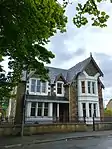
| |||
| Keith Street Industrial Female School | 58°12′40″N 6°23′12″W | Category B | 41702 | Upload Photo | |||
| Matheson Road And Scotland Street, Free Presbyterian Church Including Boundary Walls, Gates And Railings | 58°12′42″N 6°23′00″W | Category B | 41730 | 
| |||
| 8 North Beach | 58°12′30″N 6°23′28″W | Category B | 41734 | Upload Photo | |||
| South Beach, Cromwell Street And Point Street, Municipal Buildings | 58°12′30″N 6°23′19″W | Category B | 41738 | 
| |||
| Tiumpan Head Lighthouse and Attendant Buildings | 58°15′39″N 6°08′21″W | Category C(S) | 19209 | 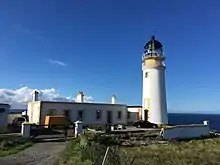
| |||
| Gress, Old Church | 58°17′26″N 6°17′03″W | Category B | 18673 | Upload Photo | |||
| Cromwells Building Corner Cromwell Street And Francis Street | 58°12′31″N 6°23′17″W | Category B | 41679 | Upload Photo | |||
| 23-29 (Odd Nos) Francis Street | 58°12′32″N 6°23′00″W | Category C(S) | 41684 | Upload Photo | |||
| 25 Kenneth Street | 58°12′32″N 6°23′13″W | Category C(S) | 41705 | Upload Photo | |||
| Kenneth Street, Masonic Hall Including Boundary Walls, Gatepiers, Railings And Arch | 58°12′38″N 6°23′15″W | Category C(S) | 41708 | Upload Photo | |||
| Lewis Street, Court House | 58°12′36″N 6°23′03″W | Category B | 41710 | 
| |||
| 13 Matheson Road Claremont Including Boundary Walls Gates And Gatepiers | 58°12′42″N 6°22′57″W | Category B | 41720 | 
| |||
| Lews Castle Driveway Bridge Close To North End Of Mansion | 58°12′43″N 6°23′40″W | Category C(S) | 18827 | Upload Photo | |||
| Lews Castle | 58°12′42″N 6°23′39″W | Category A | 18677 | .jpg.webp)
| |||
| 67 Keith Street Including Boundary Wall And Railings | 58°12′42″N 6°23′11″W | Category C(S) | 50798 | Upload Photo | |||
| Amity House | 58°12′28″N 6°23′30″W | Category B | 41674 | Upload Photo | |||
| Church Street And Matheson Road Bbc Rosebank Including Boundary Walls And Railings | 58°12′40″N 6°22′59″W | Category C(S) | 41676 | Upload Photo | |||
| 50 Church Street And Lewis Street, Ta Hall Building | 58°12′39″N 6°23′03″W | Category C(S) | 41677 | Upload Photo | |||
| Francis Street St Peter's Episcopal Church Including Perimeter Wall Gates And Gatepiers | 58°12′33″N 6°22′58″W | Category B | 41685 | 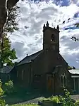
| |||
| 38 ,40 Francis Street | 58°12′33″N 6°23′01″W | Category C(S) | 41687 | 
| |||
| 2 And 4 Garden Road Including Garden Boundary Wall, Gates And Railings | 58°12′32″N 6°22′56″W | Category B | 41690 | Upload Photo | |||
| James Street And Bells Road, Old Co-Op Yard Buildings | 58°12′28″N 6°22′58″W | Category C(S) | 41695 | Upload Photo | |||
| 18, 20 James Street Including Boundary Walls Gates And Gatepiers | 58°12′29″N 6°23′00″W | Category B | 41697 | Upload Photo | |||
| 28 And 30 James Street, Park Guest House, Including Boundary Walls, Gates And Gatepiers | 58°12′31″N 6°22′56″W | Category B | 41700 | Upload Photo | |||
| 24 ,26 Lewis Street | 58°12′37″N 6°23′06″W | Category C(S) | 41713 | Upload Photo | |||
| Matheson Road And Goathill Road, High Church Including Boundary Walls, Gatepiers And Railings | 58°12′39″N 6°22′56″W | Category B | 41722 | 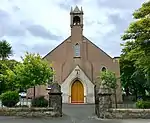
| |||
| 6 Matheson Road, Balone, Including Boundary Walls Gate And Railings | 58°12′36″N 6°22′57″W | Category B | 41724 | Upload Photo | |||
| 14 Matheson Road Including Boundary Walls Gates And Railings | 58°12′46″N 6°23′02″W | Category B | 41726 | Upload Photo | |||
| 23 Matheson Street And Robertson Road, Including Boundary Walls, Gates And Railings | 58°12′46″N 6°22′59″W | Category B | 41731 | Upload Photo | |||
| Springfield Road School Block And Adjoining Hall | 58°12′37″N 6°22′52″W | Category C(S) | 41741 | 
| |||
| Ui Church And Graveyard (St Columba's) | 58°12′26″N 6°17′00″W | Category A | 19210 | 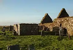
| |||
| Lews Castle Creed Lodge Including Gateway And Driveway Bridge Nearby | 58°12′20″N 6°25′10″W | Category C(S) | 18816 | Upload Photo | |||
| Knockgarry | 58°12′26″N 6°21′42″W | Category C(S) | 18676 | Upload Photo | |||
| 16, 18 Cromwell Street, The Town House | 58°12′32″N 6°23′18″W | Category B | 41682 | 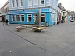
| |||
| Matheson Road And 37 Church Street Barvas Lodge Including Boundary Walls Gates And Gatepiers | 58°12′39″N 6°22′59″W | Category B | 41729 | 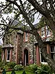
| |||
| Lewis War Memorial | 58°13′19″N 6°24′01″W | Category B | 19211 | .jpg.webp)
| |||
| 36 Francis Street | 58°12′33″N 6°23′02″W | Category C(S) | 41688 | Upload Photo | |||
| 29 Kenneth Street | 58°12′33″N 6°23′13″W | Category C(S) | 41706 | Upload Photo | |||
| 15 Matheson Road The Sheiling, Including Boundary Walls, Gate And Railings | 58°12′43″N 6°22′58″W | Category C(S) | 41721 | Upload Photo | |||
| 8 Matheson Road, Park House, Including Boundary Walls, Gates And Gatepiers | 58°12′37″N 6°22′58″W | Category B | 41725 | Upload Photo | |||
| 18 Matheson Road | 58°12′48″N 6°23′03″W | Category B | 41728 | Upload Photo | |||
| North Beach Lewis Hotel | 58°12′30″N 6°23′27″W | Category B | 41732 | Upload Photo | |||
| 32 Scotland Street | 58°12′43″N 6°23′01″W | Category B | 41737 | Upload Photo | |||
| Springfield Road Tower Of Nicolson Institute | 58°12′32″N 6°22′51″W | Category B | 41742 | 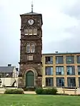
| |||
| Garry Bridge, Beyond Tolsta | 58°22′13″N 6°13′25″W | Category B | 18672 | 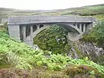
| |||
| 7 James Street | 58°12′28″N 6°23′01″W | Category B | 41696 | Upload Photo | |||
| 32 James Street Tower Guest House Including Perimeter Walls, Gates And Railings | 58°12′31″N 6°22′55″W | Category C(S) | 41701 | Upload Photo | |||
| Kenneth Street And Francis Street, Martins Memorial Church And Hall Including Boundary Walls, Gates And Railings | 58°12′31″N 6°23′10″W | Category B | 41703 | 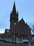
| |||
| Kenneth Street Free Church | 58°12′34″N 6°23′12″W | Category C(S) | 41707 | Upload Photo | |||
| Matheson Road And Springfield Road, Springfield House | 58°12′35″N 6°22′54″W | Category B | 41716 | Upload Photo | |||
| 7 Matheson Road Including Boundary Walls, Gates And Gatepiers | 58°12′38″N 6°22′55″W | Category B | 41718 | 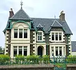
| |||
| 16 Matheson Road, Free Presbyterian Manse, Including Boundary Walls, Gates And Railings | 58°12′47″N 6°23′02″W | Category B | 41727 | Upload Photo | |||
| Porter's Lodge, Lews Castle Lodge At Bayhead, Including Quadrant Walls | 58°12′57″N 6°23′13″W | Category B | 18815 | .jpg.webp)
| |||
| Tong, Tong Farmhouse, Former Parish Church Manse Including Gatepiers | 58°14′21″N 6°21′08″W | Category C(S) | 50803 | Upload Photo | |||
| 16 Francis Street, Post Office Building | 58°12′32″N 6°23′11″W | Category B | 41686 | Upload Photo | |||
| 7 Kenneth Street Religious Book Shop | 58°12′32″N 6°23′14″W | Category B | 41704 | Upload Photo | |||
| Lewis Street And Church Street, St Columba's Old Parish Church | 58°12′37″N 6°23′02″W | Category B | 41711 | 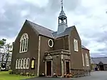
| |||
| 31 ,33 Lewis Street, Including Garden Walls And Railings | 58°12′42″N 6°23′06″W | Category B | 41712 | Upload Photo | |||
| Matheson Road And Springfield Road, School Block | 58°12′34″N 6°22′53″W | Category B | 41715 | 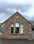
| |||
| Lews Castle, Lodges, Boundary Walls, Sea Walls And Tower Near Stornoway Harbour Including Cuddy Point | 58°12′36″N 6°23′30″W | Category A | 19206 | 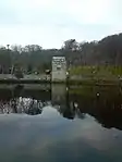
| |||
| Lews Castle, Matheson Memorial | 58°12′33″N 6°23′49″W | Category B | 19207 | 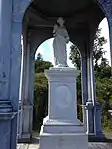
| |||
| New Tolsta, Black House (Adjacent To House At Number 48 North Tolsta) | 58°21′09″N 6°12′49″W | Category C(S) | 19208 | Upload Photo | |||
| Lews Castle, Marybank Lodge Including Gateway | 58°13′00″N 6°24′33″W | Category C(S) | 18817 | Upload Photo | |||
| Cnoc, Former Manse | 58°12′15″N 6°16′51″W | Category B | 18671 | Upload Photo |
Key
The scheme for classifying buildings in Scotland is:
- Category A: "buildings of national or international importance, either architectural or historic; or fine, little-altered examples of some particular period, style or building type."[1]
- Category B: "buildings of regional or more than local importance; or major examples of some particular period, style or building type, which may have been altered."[1]
- Category C: "buildings of local importance; lesser examples of any period, style, or building type, as originally constructed or moderately altered; and simple traditional buildings which group well with other listed buildings."[1]
In March 2016 there were 47,288 listed buildings in Scotland. Of these, 8% were Category A, and 50% were Category B, with the remaining 42% being Category C.[2]
Notes
- Sometimes known as OSGB36, the grid reference (where provided) is based on the British national grid reference system used by the Ordnance Survey.
• "Guide to National Grid". Ordnance Survey. Retrieved 12 December 2007.
• "Get-a-map". Ordnance Survey. Retrieved 17 December 2007. - Historic Environment Scotland assign a unique alphanumeric identifier to each designated site in Scotland, for listed buildings this always begins with "LB", for example "LB12345".
References
- All entries, addresses and coordinates are based on data from Historic Scotland. This data falls under the Open Government Licence
- "What is Listing?". Historic Environment Scotland. Retrieved 29 May 2018.
- Scotland's Historic Environment Audit 2016 (PDF). Historic Environment Scotland and the Built Environment Forum Scotland. pp. 15–16. Retrieved 29 May 2018.
This article is issued from Wikipedia. The text is licensed under Creative Commons - Attribution - Sharealike. Additional terms may apply for the media files.