List of listed buildings in Urquhart and Glenmoriston
This is a list of listed buildings in the parish of Urquhart and Glenmoriston in Highland, Scotland.
List
| Name | Location | Date Listed | Grid Ref. [note 1] | Geo-coordinates | Notes | LB Number [note 2] | Image |
|---|---|---|---|---|---|---|---|
| Glenmoriston, Ceannacroc Bridge (Old) Over River Moriston | 57°09′09″N 4°55′55″W | Category B | 14994 |  Upload Photo | |||
| Glenurquhart, Corrimony Burial Ground | 57°19′56″N 4°41′54″W | Category C(S) | 14998 | Upload Photo | |||
| Drumnadrochit, Temple House East And Temple House West, Former Temple Cottages | 57°20′13″N 4°26′44″W | Category C(S) | 15013 | Upload Photo | |||
| Glenurquhart, Mill Of Tore And Mill Cottage | 57°19′51″N 4°34′22″W | Category B | 15014 | Upload Photo | |||
| Glenurquhart, St Ninians Episcopal Church | 57°20′14″N 4°36′29″W | Category C(S) | 15018 | .jpg.webp)
| |||
| Invermoriston, Burial Ground And 2 Pairs Of Gate Piers | 57°12′48″N 4°36′52″W | Category B | 15023 | Upload Photo | |||
| Loch Ashlaich, Shooting Box And Bothy | 57°16′30″N 4°38′24″W | Category C(S) | 19486 | Upload Photo | |||
| Glenmoriston, Torgoyle Bridge Over River Moriston | 57°10′33″N 4°47′55″W | Category A | 14996 | Upload Photo | |||
| Drumnadrochit, Old Kilmore Burial Ground And Watch-House | 57°19′56″N 4°28′03″W | Category C(S) | 15012 | Upload Photo | |||
| Glenurquhart, Shewglie | 57°19′50″N 4°37′52″W | Category B | 15015 | Upload Photo | |||
| Glenurquhart, Corrimony Grange Barn | 57°20′08″N 4°41′53″W | Category A | 14997 | Upload Photo | |||
| Drumnadrochit, Kilmore Parish Church Of Scotland And Burial Ground | 57°19′51″N 4°28′41″W | Category B | 15011 | Upload Photo | |||
| Invermoriston, "Barracks" And Servants' Tunnel To Former Mansion | 57°12′42″N 4°36′27″W | Category B | 15017 | Upload Photo | |||
| Invermoriston, Church Of Scotland | 57°12′56″N 4°37′12″W | Category B | 15022 | Upload Photo | |||
| Drumnadrochit, Allanmore | 57°20′09″N 4°29′56″W | Category C(S) | 14993 | Upload Photo | |||
| Drumnadrochit, Benleva (Former Church Of Scotland Manse) | 57°19′56″N 4°28′16″W | Category B | 15004 | Upload Photo | |||
| By Invermoriston, Alltsaigh House | 57°14′12″N 4°33′30″W | Category B | 15016 | Upload Photo | |||
| Lochletter Farm, Garden Pavilion | 57°19′54″N 4°35′37″W | Category B | 49692 | Upload Photo | |||
| Glenmoriston, Achlain House | 57°10′15″N 4°50′52″W | Category C(S) | 14995 | Upload Photo | |||
| Drumnadrochit, Dhivach Lodge | 57°18′41″N 4°30′11″W | Category B | 15007 | Upload Photo | |||
| Drumnadrochit, Drumnadrochit Hotel | 57°20′15″N 4°28′40″W | Category B | 15008 | Upload Photo | |||
| Drumnadrochit, Greenlea | 57°20′12″N 4°28′47″W | Category B | 15010 | Upload Photo | |||
| Invermoriston, Road Bridge Over River Moriston | 57°12′44″N 4°37′05″W | Category B | 15025 | Upload Photo | |||
| Glenurquhart, Free Church | 57°20′20″N 4°30′34″W | Category C(S) | 15001 | .jpg.webp)
| |||
| Glenurquhart, Lockletter Bridge Over River Enrick | 57°20′08″N 4°35′14″W | Category B | 15003 | Upload Photo | |||
| Drumnadrochit, Bridge Over River Enrick | 57°20′14″N 4°28′49″W | Category C(S) | 15005 | Upload Photo | |||
| Drumnadrochit, Glenurquhart Secondary School And Schoolhouse | 57°19′57″N 4°28′38″W | Category B | 15009 | Upload Photo | |||
| Invermoriston, Gazebo. (In Policies Of Invermoriston House) | 57°12′42″N 4°36′59″W | Category B | 15020 | Upload Photo | |||
| Urquhart Castle | 57°19′29″N 4°26′29″W | Category A | 15026 | 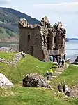
| |||
| Glenurquhart, Old Corrimony | 57°20′04″N 4°41′54″W | Category B | 15000 | Upload Photo | |||
| Glenurquhart, Kilmartin Hall And Garden Walls | 57°20′20″N 4°36′03″W | Category B | 15002 | Upload Photo | |||
| Drumnadrochit, Cnocan Burra Burial Ground | 57°19′48″N 4°29′04″W | Category C(S) | 15006 | Upload Photo | |||
| Invermoriston, Cottage And Pottery Studio (By Old Bridge) (Old Smithy Cottage) | 57°12′47″N 4°37′06″W | Category C(S) | 15019 | Upload Photo | |||
| Glenurquhart, Corrimony Bridge Over River Enrick | 57°20′04″N 4°41′48″W | Category B | 14999 | Upload Photo | |||
| Invermoriston, Home Farm And Former Barn To Rear | 57°12′45″N 4°35′58″W | Category A | 15021 | Upload Photo | |||
| Invermoriston, Old Bridge Over River Moriston | 57°12′45″N 4°37′07″W | Category B | 15024 | Upload Photo |
Key
The scheme for classifying buildings in Scotland is:
- Category A: "buildings of national or international importance, either architectural or historic; or fine, little-altered examples of some particular period, style or building type."[1]
- Category B: "buildings of regional or more than local importance; or major examples of some particular period, style or building type, which may have been altered."[1]
- Category C: "buildings of local importance; lesser examples of any period, style, or building type, as originally constructed or moderately altered; and simple traditional buildings which group well with other listed buildings."[1]
In March 2016 there were 47,288 listed buildings in Scotland. Of these, 8% were Category A, and 50% were Category B, with the remaining 42% being Category C.[2]
See also
Notes
- Sometimes known as OSGB36, the grid reference (where provided) is based on the British national grid reference system used by the Ordnance Survey.
• "Guide to National Grid". Ordnance Survey. Retrieved 12 December 2007.
• "Get-a-map". Ordnance Survey. Retrieved 17 December 2007. - Historic Environment Scotland assign a unique alphanumeric identifier to each designated site in Scotland, for listed buildings this always begins with "LB", for example "LB12345".
References
- All entries, addresses and coordinates are based on data from Historic Scotland. This data falls under the Open Government Licence
- "What is Listing?". Historic Environment Scotland. Retrieved 29 May 2018.
- Scotland's Historic Environment Audit 2016 (PDF). Historic Environment Scotland and the Built Environment Forum Scotland. pp. 15–16. Retrieved 29 May 2018.
This article is issued from Wikipedia. The text is licensed under Creative Commons - Attribution - Sharealike. Additional terms may apply for the media files.