List of listed buildings in Urquhart and Logie Wester
This is a list of listed buildings in the parish of Urquhart and Logie Wester in Highland, Scotland.
List
| Name | Location | Date Listed | Grid Ref. [note 1] | Geo-coordinates | Notes | LB Number [note 2] | Image |
|---|---|---|---|---|---|---|---|
| Conon Mains Dovecote | 57°32′51″N 4°27′09″W | Category B | 14900 |  Upload Photo | |||
| Drummondreach | 57°35′07″N 4°22′50″W | Category C(S) | 14904 | Upload Photo | |||
| Ferintosh Free Church | 57°34′47″N 4°23′11″W | Category B | 14905 | .jpg.webp)
| |||
| Urquhart (Old) Manse | 57°35′29″N 4°22′57″W | Category B | 14909 | .jpg.webp)
| |||
| Riverford | Conon Bridge | 57°33′38″N 4°26′22″W | Category C(S) | 14913 | Upload Photo | ||
| Larchfield, Station Road | Conon Bridge | 57°33′53″N 4°26′10″W | Category B | 14912 | 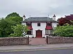
| ||
| Conon House, Gatepiers And Gates | 57°32′54″N 4°26′39″W | Category B | 14899 | .jpg.webp)
| |||
| Conon Bridge Hotel | Conon Bridge | 57°34′05″N 4°26′22″W | Category B | 14902 | .jpg.webp)
| ||
| Conon Cottage and 1-6 (Inclusive Nos) Conon Homes With Lych Gate and Boundary Wall, School Road | Conon Bridge | 57°33′39″N 4°26′11″W | Category C(S) | 44622 | .jpg.webp)
| ||
| Kinkell Castle, and Surrounding Wall and Studio Cottage | 57°33′21″N 4°25′07″W | Category A | 14906 | .jpg.webp)
| |||
| Alma Cottage and Beaufort | Culbokie | 57°36′06″N 4°20′20″W | Category C(S) | 14916 | Upload Photo | ||
| Monument To Sir Hector Macdonald | Mulbuie | 57°32′14″N 4°25′21″W | Category C(S) | 14907 | .jpg.webp)
| ||
| The Drouthy Duck (Riverside Tavern), High Street | Conon Bridge | 57°34′04″N 4°26′24″W | Category C(S) | 51658 | .jpg.webp)
| ||
| Conan House (Conon House) | 57°33′02″N 4°27′03″W | Category B | 14898 | .jpg.webp)
| |||
| Conan Mains Steading | 57°32′51″N 4°27′13″W | Category B | 14901 | .jpg.webp)
| |||
| Teanahinch | 57°35′05″N 4°23′36″W | Category B | 14908 | Upload Photo | |||
| Urquhart Parish Church | 57°35′19″N 4°22′50″W | Category B | 14910 | .jpg.webp)
| |||
| Urquhart Old Burial Ground And Remains Of Previous Parish Church | 57°35′39″N 4°22′35″W | Category B | 14911 | .jpg.webp)
| |||
| Conon Bridge Railway Bridge | Conon Bridge | 57°34′05″N 4°26′34″W | Category B | 14903 | .jpg.webp) |
Key
The scheme for classifying buildings in Scotland is:
- Category A: "buildings of national or international importance, either architectural or historic; or fine, little-altered examples of some particular period, style or building type."[1]
- Category B: "buildings of regional or more than local importance; or major examples of some particular period, style or building type, which may have been altered."[1]
- Category C: "buildings of local importance; lesser examples of any period, style, or building type, as originally constructed or moderately altered; and simple traditional buildings which group well with other listed buildings."[1]
In March 2016 there were 47,288 listed buildings in Scotland. Of these, 8% were Category A, and 50% were Category B, with the remaining 42% being Category C.[2]
See also
Notes
- Sometimes known as OSGB36, the grid reference (where provided) is based on the British national grid reference system used by the Ordnance Survey.
• "Guide to National Grid". Ordnance Survey. Retrieved 12 December 2007.
• "Get-a-map". Ordnance Survey. Retrieved 17 December 2007. - Historic Environment Scotland assign a unique alphanumeric identifier to each designated site in Scotland, for listed buildings this always begins with "LB", for example "LB12345".
References
- All entries, addresses and coordinates are based on data from Historic Scotland. This data falls under the Open Government Licence
- "What is Listing?". Historic Environment Scotland. Retrieved 29 May 2018.
- Scotland's Historic Environment Audit 2016 (PDF). Historic Environment Scotland and the Built Environment Forum Scotland. pp. 15–16. Retrieved 29 May 2018.
This article is issued from Wikipedia. The text is licensed under Creative Commons - Attribution - Sharealike. Additional terms may apply for the media files.