List of municipalities and counties on the Mexico–United States border
This is a list of all counties and municipalities (municipios in Spanish) that are directly on the Mexico–United States border. A total of 37 municipalities and 23 counties, spread across 6 Mexican and 4 American states, are located on the border. All entities are listed geographically from west to east.
Mexico
Baja California
Sonora
Chihuahua
- Janos Municipality
- Ascensión Municipality
- Juárez Municipality
- Guadalupe Municipality (first occurrence)
- Práxedis G. Guerrero Municipality
- Guadalupe Municipality (second occurrence, since it borders Práxedis G. Guerrero on three sides)
- Ojinaga Municipality
- Manuel Benavides Municipality
Coahuila
Nuevo León
United States
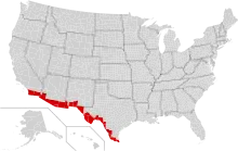
Map of U.S. counties on the border
California
New Mexico
Texas
- El Paso County
- Hudspeth County
- Jeff Davis County (border at only one point, i.e., border length is zero)
- Presidio County
- Brewster County
- Terrell County
- Val Verde County
- Kinney County
- Maverick County
- Webb County
- Zapata County
- Starr County
- Hidalgo County
- Cameron County
This article is issued from Wikipedia. The text is licensed under Creative Commons - Attribution - Sharealike. Additional terms may apply for the media files.