List of cities and towns in Jamaica
The following is a list of the most populous settlements in Jamaica.
Definitions
The following definitions have been used:
- City: Official city status on a settlement is only conferred by Act of Parliament. Only three areas have the designation; Kingston when first incorporated in 1802[1][2] reflecting its early importance over the then capital Spanish Town, Montego Bay being granted the status in 1980,[3][4][5][6] and Portmore, whose municipal council was given the city title in 2018.[7] It is not necessarily based on population counts, and while a honorific title, can confer some increased autonomy.
- Town/Village: The Statistical Institute of Jamaica considers an urban area to be any area with 2,000 or more residents.[8] A town would generally be considered to be ranked as a higher populated urban area, and a village as a minor urban area.
- Neighbourhood: Geographically obvious subdivisions of any of the above.
Cities and towns
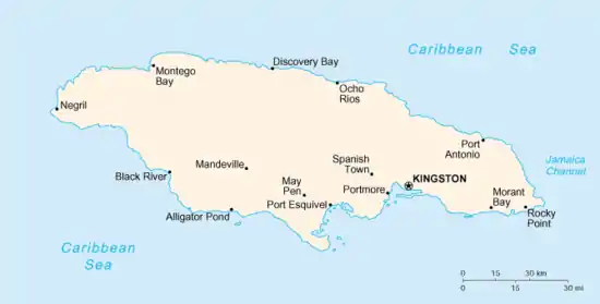
A map of Jamaica, with main settlements and notable places
Cities
| Name | Census population[9] | Coordinates | Parish | Granted | ||
|---|---|---|---|---|---|---|
| 2021 | 2011 | 2001 | ||||
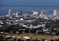
| Kingston** | 584,627 | 579,137 | 17.98°N 76.80°W | Kingston | 1802 | |
| Portmore | 182,153 | 156,469 | 17.94°N 76.87°W | Saint Catherine | 2018 | |
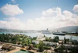
| Montego Bay* | 110,115 | 96,477 | 18.46°N 77.91°W | Saint James | 1980 | |
** Country and parish capital
* Parish capital
Chief towns
These are settled areas with 10,000 residents or more.
| Name | Census population[9] | Coordinates | Parish | ||
|---|---|---|---|---|---|
| 2021 | 2011 | 2001 | |||
| Spanish Town* | 147,152 | 131,515 | 17.99°N 76.95°W | Saint Catherine | |
| May Pen* | 61,548 | 57,334 | 17.97°N 77.24°W | Clarendon | |
| Mandeville* | 49,695 | 47,467 | 18.05°N 77.48°W | Manchester | |
| Old Harbour | 28,912 | 23,823 | 17.92°N 77.10°W | Saint Catherine | |
| Savanna-la-Mar* | 22,633 | 19,893 | 18.16°N 77.95°W | Westmoreland | |
| Ocho Rios | 16,671 | 15,769 | 18.42°N 77.11°W | Saint Ann | |
| Linstead | 15,231 | 15,660 | 18.15°N 77.02°W | Saint Catherine | |
| Port Antonio* | 14,816 | 14,568 | 18.16°N 76.38°W | Portland | |
| Saint Ann's Bay* | 11,173 | 10,441 | 18.44°N 77.22°W | Saint Ann | |
| Morant Bay* | 11,052 | 10,782 | 17.87°N 76.39°W | Saint Thomas | |
| Yallahs | 10,849 | 9,888 | 17.87°N 76.57°W | Saint Thomas | |
| Hayes | 10,639 | 10,098 | 17.88°N 77.25°W | Clarendon | |
| Santa Cruz | 10,423 | 10,785 | 18.07°N 77.72°W | Saint Elizabeth | |
Towns and villages
Villages
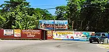
White River Rafting signs
- Accompong (Saint Elizabeth)
- Aeolus Valley (Saint Thomas)
- Airy Castle (Saint Thomas)
- Barking Lodge (Saint Thomas)
- Berry Hill (Manchester)
- Bog (Westmoreland)
- Big Woods (Westmoreland)
- Boscobel (Saint Mary)
- Bull Bay (Saint Andrew)
- Carmel (Westmoreland)
- Cattawood Springs (Portland)
- Clarendon Park (Clarendon)
- Cotterwood (Saint Elizabeth)
- Duckenfield (Saint Thomas)
- Four Paths (Clarendon)
- Haddersfield (Saint Mary)
- Hagley Gap (Saint Thomas)
- Hodges (Saint Elizabeth)
- Hopewell Hall (Saint Thomas)
- Hopewell (Clarendon)
- Hopewell (Manchester)
- Hopewell (Saint Andrew)
- Hopewell (Saint Ann)
- Hopewell (Saint Elizabeth)
- Hopewell (Westmoreland)
- Hopeton (Westmoreland)
- Knockpatrick (Manchester)
- Lloyds (Saint Thomas)
- Long Wood (Saint Elizabeth)
- Mavis Bank (Saint Andrew)
- Meadsfield (Manchester)
- Middle Quarters (Saint Elizabeth)
- Mount Rosser (Saint Catherine)
- Nanny Town (Portland)
- New Holland (Saint Elizabeth)
- New Market (Saint Elizabeth)
- New Roads (Saint Elizabeth)
- Newcastle (Saint Andrew)
- Nine Mile (Saint Ann)
- Old Pera (Saint Thomas)
- Paynes Town (Saint Elizabeth)
- Port Esquivel (Saint Catherine)
- Port Morant (Saint Thomas)
- Roxborough (Manchester)
- San San (Portland)
- Sheckles Pen (Clarendon)
- Stonehenge (Saint James)
- Walderston
- White Hall (Saint Elizabeth)
- Wood Hall (Saint Catherine)
Neighbourhoods
Kingston & St. Andrew
- Barbican
- Allerdyce
- Cherry Gardens
- Belgrade Mews
- Smokey Vale
- Constant Spring
- Denham Town
- Tivoli Gardens
- Jones Town
- Kencot
- Allman Town
- Rae Town
- Downtown Kingston
- Red Hills
- Stony Hill
- Mountain View
- Forest Gardens
- Forest Hills
- Forest Hills Gardens
- Duhaney Park
- Patrick City
- Patrick Gardens
- Washington Gardens
- Norbrook
- Queen Hill
- Meadowbrook
- Meadowbrook Estates
- Pembroke Hall
- Half Way Tree
- Eastwood Park Gardens
- Harbour View
- Port Royal
- Liguanea
- Mona
- Ithaca
- Papine
- Kintyre
- Beverley Hills
- Long Mountain
- New Kingston
- Trafalgar Park
- Hope Pastures
- Jack's Hill
- Riva Ridge
- Cross Roads
- Norbrook
- Trenchtown
- Riverton Meadows
- Seaview Gardens
- Callaloo Bed
- New Haven
- Waterhouse
- Backto
- Payne Land
- Olympic Garden
- Cockburn Gardens
- Greenwich Town
- Whitfield Town
- Marverley
- Pembrook Hall
- Zaidie Gardens
- Hughenden
- Havendale
- Molynes Gardens
- Vineyard Town
- Woodford Park
- Franklyn Town
- Eden Gardens
- Bournemouth Gardens
- Norman Gardens
- August Town
- College Common
- Elletson Flats
References
- "The Laws of Jamaica: 1799-1803". A. Aikman, printer to the King's Most Excellent Majesty. 1812.
- "A Special Gleaner Feature on Pieces of the Past - The Capital City Kingston -The first 500 years in Jamaica". old.jamaica-gleaner.com.
- "Montego Bay (Status of City) Act | Ministry of Justice - Government of Jamaica".
- "Parish profiles - Jamaica Information Service". jis.gov.jm. Retrieved 16 July 2019.
- "Major Jamaican Cities & Towns - Including the Largest City in Jamaica". My-Island-Jamaica.com. Retrieved 16 July 2019.
- "Jamaica Observer Limited". Jamaica Observer. Retrieved 16 July 2019.
- "It's now Portmore City Municipality". jamaica-gleaner.com. 3 November 2018. Retrieved 16 July 2019.
- "Urban centres grow by 5 per cent". Jamaica Observer. Retrieved 16 July 2019.
- "Population and Housing Census 2011: General Report Volume 1". statinja.gov.jm. Retrieved 19 March 2023.
External links
Wikimedia Commons has media related to Populated places in Jamaica.
- World Gazetteer, Jamaica: Largest cities and towns with statistics of their population at archive.today (archived 2012-12-05)
- World Gazetteer, Jamaica: Maps at archive.today (archived 2013-02-09)
- Origin of Jamaican Place names
| History |
|  | |||
|---|---|---|---|---|---|
| Geography |
| ||||
| Politics | |||||
| Economy | |||||
| Society |
| ||||
This article is issued from Wikipedia. The text is licensed under Creative Commons - Attribution - Sharealike. Additional terms may apply for the media files.