List of protected heritage sites in Ans
This table shows an overview of the protected heritage sites in the Walloon town Ans. This list is part of Belgium's national heritage.
| Object | Year/architect | Town/section | Address | Coordinates | Number? | Image |
|---|---|---|---|---|---|---|
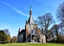
| Hombroux farm (nl) (fr) |
Ans | 50.676058°N 5.520552°E |
62003-CLT-0002-01 Info |
 De boerderij van Hombroux en ensemble van de boerderij met de omliggende terreinen | ||
| Hombroux farm (extension) (nl) (fr) |
Ans | 50.675815°N 5.521590°E |
62003-CLT-0003-01 Info |
Uitbreiding van de site van de boerderij van Hombroux geclassificeerd per koninklijk decreet van 19 juni 1978 | ||
| Hombroux farm (2nd extension) (nl) (fr) |
Ans | 50.676326°N 5.520692°E |
62003-CLT-0004-01 Info |
Tweede uitbreiding van de classificatie van de site van boerderij van Hombroux en omgeving | ||
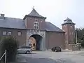
| Waroux Castle (nl) (fr) |
Ans | 50.682238°N 5.492915°E |
62003-CLT-0005-01 Info |
 De totaliteit van het kasteel van Waroux, waaronder de gevels en daken van de boerderij, de site van het kasteel en de omliggende terreinen | ||
| "Cense dite de Monfort" farm (nl) (fr) |
Ans | rue de l'Yser 200 | 50.659429°N 5.523429°E |
62003-CLT-0007-01 Info |
||
| Tumulus de Xhendremael (nl) (fr) |
Ans | 50.697360°N 5.478080°E |
62003-CLT-0008-01 Info |
 Tumulus van Xhendremael en het terrein dat de tumulus omringd | ||
| Fort de Loncin (nl) (fr) |
Ans | rue des Héros 17 | 50.674359°N 5.490874°E |
62003-CLT-0009-01 Info |
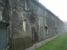 Fort van Loncin | |
| "Li Tombe di Hên'mâl" archeological site (nl) (fr) |
Ans | 50.697360°N 5.478080°E |
62003-PEX-0001-01 Info |
Tumulus van Xhendremael, archeologische site met de naam "Li Tombe di Hên'mâl" |
See also
Wikimedia Commons has media related to Cultural heritage monuments in Ans.
References
This article is issued from Wikipedia. The text is licensed under Creative Commons - Attribution - Sharealike. Additional terms may apply for the media files.