List of protected heritage sites in Bouillon
This table shows an overview of the protected heritage sites in the Walloon town Bouillon. This list is part of Belgium's national heritage.
| Object | Year/architect | Town/section | Address | Coordinates | Number? | Image |
|---|---|---|---|---|---|---|
| Old castle-fortress of Bouillon, the walls, a fire escape, the bastion of Burgundy and the building and keep for the ensemble of these buildings and surrounding areas (nl) (fr) |
Bouillon Bouillon | 49.792756°N 5.065301°E |
84010-CLT-0001-01 Info |
.JPG.webp) Oude kasteel-fort van Bouillon, de wallen, een brandtrap, het bastion van Bourgogne en het wachtgebouw en het ensemble van deze gebouwen en omliggende terreinen | ||
| The bastion of Brittany and the bastion of the Dauphin (nl) (fr) |
Bouillon Bouillon | 49.797538°N 5.067021°E |
84010-CLT-0003-01 Info |
.JPG.webp) Het bastion van Bretagne en het bastion van de Dauphin | ||
| Ensemble of two mansions in the vicinity of the former castle of Bouillon and the surrounding areas (nl) (fr) |
Bouillon Bouillon | 49.794632°N 5.065376°E |
84010-CLT-0005-01 Info |
|||
| Mansion near the castle of Bouillon (nl) (fr) |
Bouillon Bouillon | Rue de Brutz 39 | 49.795382°N 5.066505°E |
84010-CLT-0006-01 Info |
.JPG.webp) Patriciërshuis in de buurt van het kasteel van Bouillon | |
| Mansion near the castle of Bouillon (nl) (fr) |
Bouillon Bouillon | place des Champs-Prévôt n°10 | 49.796951°N 5.066376°E |
84010-CLT-0007-01 Info |
.JPG.webp) Patriciërshuis in de buurt van het kasteel van Bouillon | |
| Ducal Museum: the two buildings with collections (nl) (fr) |
Bouillon Bouillon | Place Ducale | 49.794383°N 5.068077°E |
84010-CLT-0008-01 Info |
.JPG.webp) Museum Ducal: de twee gebouwen met de collecties | |
| Town hall (nl) (fr) |
Bouillon Bouillon | Place Ducale | 49.794708°N 5.068038°E |
84010-CLT-0010-01 Info |
.JPG.webp) Raadhuis | |
| Vauban barracks: facades and roofs (nl) (fr) |
Bouillon Bouillon | boulevard Heynen n°16 | 49.797057°N 5.069282°E |
84010-CLT-0011-01 Info |
 Kazernes Vauban: gevels en daken | |
| Extending the classification of barracks of Vauban (nl) (fr) |
Bouillon Bouillon | 49.796476°N 5.069434°E |
84010-CLT-0012-01 Info |
|||
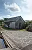
| Rural building in La Cornette at Les Hayons (now a farm) (nl) (fr) |
Les Hayons Bouillon | Rue de la Cornette 55 | 49.813771°N 5.146018°E |
84010-CLT-0013-01 Info |
||
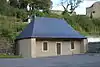
| Watering hole (nl) (fr) |
Noirefontaine Bouillon | Rue de la Sentinelle | 49.816570°N 5.090196°E |
84010-CLT-0014-01 Info |
 Drinkplaats | |
| Farm in Frahan (nl) (fr) |
Rochehaut Bouillon | n°22, Frahan | 49.834171°N 5.000886°E |
84010-CLT-0016-01 Info |
||
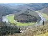
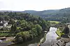
| Bend of the Semois river in Frahan and setting of conservation (nl) (fr) |
Rochehaut Bouillon | 49.839971°N 4.999841°E |
84010-CLT-0017-01 Info |
.JPG.webp) Bocht van de Semois te Frahan en instelling beschermingszone | ||
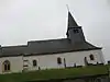
| Set of St. Firminuskerk, surrounding wall of the churchyard and ensemble of the church, the graveyard and surrounding wall (nl) (fr) |
Rochehaut Bouillon | 49.840253°N 5.006028°E |
84010-CLT-0021-01 Info |
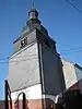 Geheel van Sint-Firminuskerk, omringende muur rond kerkhof en ensemble van de kerk, het kerkhof en de muur er rond heen | ||
| Part of the ensemble of the Tombeau du Géant, on the territory of the municipalities Rochehaut and Ucimont, and the places called "Les Grandes Falloiges, les Petites Falloiges, Ravers, Queue de Terme, Fond d'Ucimont, Pres de la Semois, Pré de la Bouche à l'eau, the Assences Pigerue, Pre Saint-Firmin, Pigerue la, le Fretis, Goutai the Wires, Gouttel la, la Rigonel, Scoticainay, la Wire des Quoees, the Couplemou, la Virée du Ru , le Ru " (nl) (fr) |
Rochehaut en Ucimont Bouillon | 49.833889°N 5.013720°E |
84010-CLT-0025-01 Info |
 Deel van het ensemble van de Tombeau du Géant, op het grondgebied van de sections Rochehaut en Ucimont, en de plaatsen "Les Grandes Falloiges, les Petites Falloiges, Ravers, Queue de Terme, Fond d'Ucimont, Prés de la Semois, Pré de la Bouche à l'eau, Assences de Pigerue, Pré Saint-Firmin, la Pigerue, le Frétis, Goutai de Wires, la Gouttel, la Rigonel, Scoticainay, la Wiré des Quoées, de Couplemou, la Virée du Ru, le Ru" | ||
| Part of the site of Tombeau du Géant, on the territory of the municipalities Ucimont, Botassart and Corbion and places Merleux Han, le cul de Merleux Han Noires Eaux, Tibetrix, the Pres Germovez, Germovez, Lovete, Loquet, Devant le Mont , Sarsucot (nl) (fr) |
Corbion en Ucimont Bouillon | 49.808248°N 5.008191°E |
84010-CLT-0026-01 Info |
.jpg.webp) Deel van de site van Tombeau du Géant, op het grondgebied van de sections Ucimont, Botassart en Corbion en de plaatsen Merleux Han, le Cul de Merleux Han, Noires Eaux, Tibetrix, Prés de Germovez, Germovez, Loveté, Loquet, Devant le Mont, Sarsucot | ||
| Part of the site of Tomeau du Geant in Sensenruth, Ucimont and Corbion (nl) (fr) |
Corbion, Sensenruth en Ucimont Bouillon | 49.822979°N 5.030689°E |
84010-CLT-0027-01 Info |
.JPG.webp) Deel van de site van Tomeau du Géant te Sensenruth, Ucimont et Corbion | ||
| Part of the ensemble of the Tombeau du Géant and includes the places, "L'Orient-Traicot, Tailles des Augustins, l'Epinne, Clernot, Au-dessus the Clernot, l'Ecaillire, du Pré Plane" (nl) (fr) |
Corbion Bouillon | 49.804026°N 5.024737°E |
84010-CLT-0028-01 Info |
.JPG.webp) Deel van het ensemble van de Tombeau du Géant en omvat de plaatsen "L'Orient-Traicot, Tailles des Augustins, l'Epinne, Clernot, Au-dessus de Clernot, l'Ecaillire, Pré du Plane" | ||
| Moulin de Rivage at the Tombeau du Géant, facades and roofs, machine room, channel water to the old mill wheel (nl) (fr) |
Bouillon | 49.817697°N 5.042981°E |
84010-CLT-0029-01 Info |
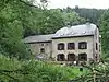 Moulin de Rivage bij de Tombeau du Géant, gevels en daken, machineruimte, kanaal voor watertoevoer naar het oude rad | ||
| Roche aux Fees and the adjacent area of the Semois called Vanne des Bains (nl) (fr) |
Bouillon | 49.790124°N 5.064723°E |
84010-CLT-0031-01 Info |
 "Roche aux Fées" en het aangrenzende gebied van de Semois genaamd Vanne des Bains | ||
| Chapel of the Immaculate Conception and the wall around the cemetery (nl) (fr) |
Bouillon | 49.821706°N 5.048344°E |
84010-CLT-0033-01 Info |
.JPG.webp) Kapel van Immaculée Conception en de muur rond de begraafplaats | ||
| Church of Saint-Lambert and the ensemble of the building and its surroundings (nl) (fr) |
Bouillon | 49.825345°N 5.072720°E |
84010-CLT-0034-01 Info |
 Kerk Saint-Lambert en het ensemble van het gebouw en diens omgeving | ||
| House of the commander, also known as the home of the Provost, located between Boulevard Heynen and Champ Prévôt: facades and roofs and walls of the walled garden (nl) (fr) |
Bouillon Bouillon | 49.797271°N 5.067400°E |
84010-CLT-0035-01 Info |
.JPG.webp) Huis van de commandant, ook wel bekend als huis van de provoost, gelegen tussen Boulevard Heynen en Champ Prévôt: gevels en daken en de muren van de ommuurde tuin | ||
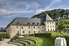
| Castle farm of Dohan: facades and roofs of buildings from the 18th century, large lounge and staircase, and the ensemble of the building and its surroundings (nl) (fr) |
Dohan Bouillon | Dohan Haut | 49.794962°N 5.141898°E |
84010-CLT-0036-01 Info |
||
| House (nl) (fr) |
Rochehaut Bouillon | Rue de la Cense 19 | 49.840109°N 5.004168°E |
84010-CLT-0037-01 Info |
||
| Priory of the Sepulchrines: facades and roofs (nl) (fr) |
Bouillon Bouillon | Rue du Collège | 49.793623°N 5.069520°E |
84010-CLT-0038-01 Info |
 Priorij van de Sépulchrines: gevels en daken | |
| House called "la Poulie" (old gatekeepers house), excluding contemporary extensions (nl) (fr) |
Bouillon Bouillon | Rue de la Poulie 6, Bouillon | 49.79433°N 5.0655°E |
84010-CLT-0039-01 Info |
 Huis genaamd "la Poulie" (oude portierswoning van Polie), uitgezonderd hedendaagse aanbouwen | |
| Farm in Frahan (nl) (fr) |
Rochehaut Bouillon | n°23, gehucht Frahan | 49.834243°N 5.000781°E |
84010-CLT-0040-01 Info |
||
| Old castle-fortress of Bouillon, the walls, the fire escape, and the main bastion of Burgundy, and the ensemble of buildings and surrounding areas (nl) (fr) |
Bouillon Bouillon | 49.792756°N 5.065301°E |
84010-PEX-0001-01 Info |
%253B_vue_de_la_partie_occidentale_du_ch%C3%A2teau-fort_(XIIIe%E2%80%93XIX_si%C3%A8cles).jpg.webp) Oud kasteel-fort van Bouillon, de wallen, de brandtrap, bastion Bourgogne en het hoofdgebouw, en het ensemble van de gebouwen en de omliggende terreinen | ||
| Bend of the Semois in Frahan (nl) (fr) |
Rochehaut Bouillon | 49.839971°N 4.999841°E |
84010-PEX-0002-01 Info |
.JPG.webp) Bocht in de Semois te Frahan |
See also
References
- Belgian heritage register: Direction générale opérationnelle - Aménagement du territoire, Logement, Patrimoine et Energie (DG4)
- www.dglive.be