List of highways in Ponce, Puerto Rico
This is a list of highways in Ponce, Puerto Rico. The list focuses on major, signed, roads in the municipality of Ponce, Puerto Rico.[1][2] The list shows local roads, that is, those with both terminuses within the municipality ("intra-municipal" roads), as well as inter-municipal roads.
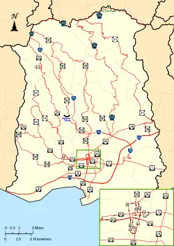
Map of major roads in Ponce, Puerto Rico, shown in red.
List of highways
.jpg.webp) PR-2 (Ponce Bypass) looking west
PR-2 (Ponce Bypass) looking west%252C_Bo._Machuelo_Abajo%252C_Ponce%252C_Puerto_Rico%252C_mirando_al_oeste_(IMG_3417).jpg.webp)
| Route | Network | Axis | Southern or western terminus | Northern or eastern terminus | Type | Length, km (mi) | Notes | Photo |
|---|---|---|---|---|---|---|---|---|
| PR-1 | Primary | S to N | Ponce | San Juan | Inter-municipal | 133.7 (83.1)[3] | via Cayey | .jpg.webp) |
| PR-1P | Primary | W to E | Ponce | Tercero | Local | unknown | — | .jpg.webp) |
| PR-2 | Primary | S to N | Ponce | San Juan | Inter-municipal | 230 (140) | via Mayagüez |  |
| PR-2R | Primary | S to N | Canas | Canas Urbano | Local | 1.6 (0.99) | — | .jpg.webp) |
| PR-9 | Primary | S to N | Vayas | Canas | Local | 12 (7.5) | via Portugués; a.k.a. Expreso Román Baldorioty de Castro | .jpg.webp) |
| PR-10 | Primary | S to N | Ponce | Arecibo | Inter-municipal | 68.26 (42.41)[4] | via Adjuntas | %252C_Puerto_Rico's_first_green_road_(DSC05642C).jpg.webp) |
| PR-12 | Primary | S to N | Playa | Ponce | Local | 5.28 (3.28)[5] | a.k.a. Expreso Santiago de los Caballeros | %252C_en_Ponce%252C_PR_(DSC01665).jpg.webp) |
| PR-14 | Primary | W to E | Ponce | Cayey | Inter-municipal | 73.1 (45.4)[6] | — | %252C_Bo._Machuelo_Abajo%252C_Ponce%252C_Puerto_Rico%252C_visto_desde_intersecci%C3%B3n_con_la_Av._Fagot%252C_mirando_al_este_(DSC02967).jpg.webp) |
| PR-14P | Primary | W to E | Ponce | Machuelo Abajo | Local | unknown | — | .jpg.webp) |
| PR-14R | Primary | W to E | Ponce | Machuelo Abajo | Local | unknown | — | %252C_Bo._Machuelo_Abajo%252C_Ponce%252C_PR%252C_mirando_al_oeste_(DSC01863A).jpg.webp) |
| PR-52 | Primary | S to N | Ponce | San Juan | Inter-municipal | 108 (67)[7] | a.k.a. Expreso Luis A. Ferré | .jpg.webp) |
| PR-123 | Secondary | S to N | Ponce | Arecibo | Inter-municipal | 60 (37) | via Adjuntas | .jpg.webp) |
| PR-123P | Secondary | S to N | Primero | Ponce | Local | unknown | — | .jpg.webp) |
| PR-132 | Secondary | W to E | Guayanilla | Ponce | Inter-municipal | 25.9 (16.1)[8] | — | .jpg.webp) |
| PR-133 | Secondary | W to E | Ponce | San Antón | Local | 2.0 (1.2)[5] | a.k.a. Calle Comercio | %252C_Barrio_San_Ant%C3%B3n%252C_Ponce%252C_Puerto_Rico%252C_mirando_al_este-sureste_(DSC03365).jpg.webp) |
| PR-139 | Secondary | S to N | Ponce | Maragüez | Local | 24.8 (15.4) | — | .jpg.webp) |
| PR-139R | Secondary | S to N | Machuelo Arriba | Maragüez | Local | 2.9 (1.8)[9] | — | .jpg.webp) |
| PR-143 | Secondary | W to E | Adjuntas | Barranquitas | Inter-municipal | 58.7 (36.5)[10][11] | via Ponce | _y_acercandose_a_la_Carretera_PR-577_hacia_el_Cerro_Maravilla%252C_Barrio_Anon%252C_Ponce%252C_Puerto_Rico_(DSC01621).jpg.webp) |
| PR-163 | Secondary | W to E | Canas Urbano | San Antón | Local | 4.8 (3.0) | a.k.a. Avenida Las Américas | .jpg.webp) |
| PR-500 | Tertiary | W to E | Canas | Magueyes | Local | 1.00 (0.62) | — | .jpg.webp) |
| PR-501 | Tertiary | S to N | Ponce | Marueño | Local | 7.0 (4.3) | — | .jpg.webp) |
| PR-502 | Tertiary | S to N | Ponce | Quebrada Limón | Local | 5.3 (3.3) | — | .jpg.webp) |
| PR-503 | Tertiary | S to N | Cantera | Jayuya | Local | 21.8 (13.5) | — | .jpg.webp) |
| PR-504 | Tertiary | S to N | Ponce | Portugués | Local | 6.7 (4.2) | — | .jpg.webp) |
| PR-505 | Tertiary | S to N | Ponce | Machuelo Arriba | Local | 16.6 (10.3) | — | .jpg.webp) |
| PR-506 | Tertiary | S to N | Cantera | Vayas | Local | 2.0 (1.2) | — | .jpg.webp) |
| PR-507 | Tertiary | S to N | Capitanejo | Capitanejo | Local | unknown | As of around January 2023, this road seems to have lost its PR-507 designation as a new road is now signed with the PR-507 designation in Machuelo Arriba. This can be seen here, here, and here. This road now signed as PR-507 leads from PR-139 to the Luis A. "Wito" Morales Park. | .jpg.webp) |
| PR-510 | Tertiary | S to N | Capitanejo | Juana Díaz | Inter-municipal | 10.3 (6.4)[12][13] | — | .jpg.webp) |
| PR-511 | Tertiary | S to N | Ponce | Anón | Local | 16.4 (10.2) | — | .jpg.webp) |
| PR-515 | Tertiary | W to E | Guaraguao | Guaraguao | Local | 1.5 (0.93)[14] | — | .jpg.webp) |
| PR-516 | Tertiary | W to E | Guaraguao | Guaraguao | Local | 3.1 (1.9)[15] | — | .jpg.webp) |
| PR-520 | Tertiary | W to E | Peñuelas | Quebrada Limón | Inter-municipal | unknown | — | .jpg.webp) |
| PR-549 | Tertiary | S to N | Canas | Canas | Local | 4.2 (2.6) | — | .jpg.webp) |
| PR-577 | Tertiary | S to N | Anón | Anón | Local | 0.30 (0.19) | Cerro Maravilla; dead end road | |
| PR-578 | Tertiary | W to E | Bucaná | Sabanetas | Local | 0.9 (0.56) | — | .jpg.webp) |
| PR-581 | Tertiary | S to N | Capitanejo | Capitanejo | Local | unknown | — | .jpg.webp) |
| PR-585 | Tertiary | S to N | Canas | Playa | Local | 3.8 (2.4) | — | .jpg.webp) |
| PR-588 | Tertiary | S to N | Portugués | Portugués | Local | 1.7 (1.1)[16] | — | .jpg.webp) |
| PR-591 | Tertiary | W to E | El Tuque | El Tuque | Local | 3.1 (1.9)[17] | — | .jpg.webp) |
| PR-5139 | Tertiary | S to N | Cerrillos | Machuelo Arriba | Local | 2.8 (1.7)[18] | — | .jpg.webp) |
| PR-5506 | Tertiary | S to N | Vayas | Sabanetas | Local | 1.4 (0.87)[19] | — | .jpg.webp) |
| PR-5510 | Tertiary | S to N | Capitanejo | Juana Díaz | Inter-municipal | 1.4 (0.87)[20] | — | .jpg.webp) |
| PR-5549 | Tertiary | S to N | Canas Urbano | Canas Urbano | Local | unknown | — | .jpg.webp) |
.jpg)
.jpg)
.jpg)
References
- Maptest. Archived 2010-02-18 at the Wayback Machine Government of the Commonwealth of Puerto Rico. General Purpose Population Data, Census 2000. Unidad de Sistemas de Información Geográfica, Área de Tecnología de Información Gubernamental, Oficina de Gerencia y Presupuesto. Gobierno de Puerto Rico. Retrieved 8 October 2013.
- Webcensus. Archived 2010-08-12 at the Wayback Machine Government of the Commonwealth of Puerto Rico. General Purpose Population Data, Census 2000. Unidad de Sistemas de Información Geográfica, Área de Tecnología de Información Gubernamental, Oficina de Gerencia y Presupuesto. Gobierno de Puerto Rico. Retrieved 8 October 2013.
- La Carretera Central: un viaje escénico a la historia de Puerto Rico. Pumarada-O’Neill, Luis and Castro Arroyo, Maria de los Angeles. Centro de Investigación de Desarrollo del Recinto Universitario de Mayagüez and Oficina Estatal de Preservación Histórica de Puerto Rico. 1996. ISBN 0-9650011-2-1. page 8. Accessed 2 May 2018.
- "Listado de Sistemas Viales: Muestra" [Listing of Roadway Systems: Sampling] (PDF) (in Spanish). Puerto Rico Department of Transportation. Archived from the original (PDF) on 6 February 2011. Retrieved 13 January 2011.
- Guía de Carreteras Principales, Expresos y Autopistas. Autoridad de Carreteras y Transportación (ACT). Government of Puerto Rico. San Juan, Puerto Rico. 2010. Archived 2010-11-28 at the Wayback Machine
- Google (28 February 2020). "PR-14" (Map). Google Maps. Google. Retrieved 28 February 2020.
- Puerto Rico Highway and Transportation Authority: Upcoming P3 Projects. Puerto Rico Public-Private Partnerships Authority. Puerto Rico Projects Conference. p.35.
- Google (6 March 2020). "PR-132" (Map). Google Maps. Google. Retrieved 6 March 2020.
- Google (2 March 2020). "PR-139R" (Map). Google Maps. Google. Retrieved 2 March 2020.
- Google (2 March 2020). "PR-143 west" (Map). Google Maps. Google. Retrieved 2 March 2020.
- Google (8 March 2020). "PR-143 east" (Map). Google Maps. Google. Retrieved 8 March 2020.
- Google (1 March 2020). "PR-510 west" (Map). Google Maps. Google. Retrieved 1 March 2020.
- Google (1 March 2020). "PR-510 east" (Map). Google Maps. Google. Retrieved 1 March 2020.
- Google (1 March 2020). "PR-515" (Map). Google Maps. Google. Retrieved 1 March 2020.
- Google (1 March 2020). "PR-516" (Map). Google Maps. Google. Retrieved 1 March 2020.
- Google (1 March 2020). "PR-588" (Map). Google Maps. Google. Retrieved 1 March 2020.
- Google (1 March 2020). "PR-591" (Map). Google Maps. Google. Retrieved 1 March 2020.
- Google (16 August 2020). "PR-5139" (Map). Google Maps. Google. Retrieved 16 August 2020.
- Google (1 March 2020). "PR-5506" (Map). Google Maps. Google. Retrieved 1 March 2020.
- Google (22 March 2020). "PR-5510" (Map). Google Maps. Google. Retrieved 22 March 2020.
External links
 Media related to Roads in Ponce, Puerto Rico at Wikimedia Commons
This article is issued from Wikipedia. The text is licensed under Creative Commons - Attribution - Sharealike. Additional terms may apply for the media files.