Hawthorndale
Hawthorndale is a suburb of New Zealand's southernmost city, Invercargill. It contains the city's Eastern Cemetery, and also Bill Richardson Transport World, a truck and classic car museum.
Hawthorndale | |
|---|---|
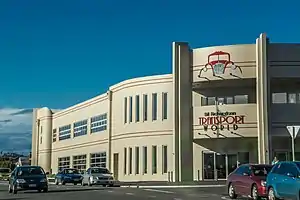 Bill Richardson Transport World | |
| Coordinates: 46.4098°S 168.3882°E | |
| Country | New Zealand |
| City | Invercargill |
| Local authority | Invercargill City Council |
| Area | |
| • Land | 149 ha (368 acres) |
| Population (June 2022)[2] | |
| • Total | 1,840 |
| Richmond | Glengarry | Mill Road |
| Turnbull Thomson Park |
|
Seaward Bush |
| Georgetown | Newfield | Rockdale |
Demographics
The suburb is part of the Turnbull Thompson Park statistical area, which covers 1.49 km2 (0.58 sq mi)[1] and had an estimated population of 1,840 as of June 2022,[2] with a population density of 1,235 people per km2.
| Year | Pop. | ±% p.a. |
|---|---|---|
| 2006 | 1,725 | — |
| 2013 | 1,731 | +0.05% |
| 2018 | 1,764 | +0.38% |
| Source: [3] | ||
The statistical area had a population of 1,764 at the 2018 New Zealand census, an increase of 33 people (1.9%) since the 2013 census, and an increase of 39 people (2.3%) since the 2006 census. There were 696 households. There were 828 males and 933 females, giving a sex ratio of 0.89 males per female. The median age was 35.3 years (compared with 37.4 years nationally), with 336 people (19.0%) aged under 15 years, 396 (22.4%) aged 15 to 29, 813 (46.1%) aged 30 to 64, and 216 (12.2%) aged 65 or older.
Ethnicities were 85.5% European/Pākehā, 17.2% Māori, 3.4% Pacific peoples, 6.3% Asian, and 1.7% other ethnicities (totals add to more than 100% since people could identify with multiple ethnicities).
The proportion of people born overseas was 10.4%, compared with 27.1% nationally.
Although some people objected to giving their religion, 50.9% had no religion, 36.4% were Christian, 0.9% were Hindu, 0.5% were Muslim, 0.2% were Buddhist and 2.9% had other religions.
Of those at least 15 years old, 198 (13.9%) people had a bachelor or higher degree, and 336 (23.5%) people had no formal qualifications. The median income was $34,000, compared with $31,800 nationally. 204 people (14.3%) earned over $70,000 compared to 17.2% nationally. The employment status of those at least 15 was that 822 (57.6%) people were employed full-time, 204 (14.3%) were part-time, and 45 (3.2%) were unemployed.[3]
Education
Ascot Community School is a full primary school serving years 1 to 8[4] with a roll of 264 students as of April 2023.[5] The school was established in 1999 through the merger three pre-existing schools:[6]
References
- "ArcGIS Web Application". statsnz.maps.arcgis.com. Retrieved 13 February 2022.
- "Population estimate tables - NZ.Stat". Statistics New Zealand. Retrieved 25 October 2022.
- "Statistical area 1 dataset for 2018 Census". Statistics New Zealand. March 2020. Turnbull Thompson Park (361900). 2018 Census place summary: Turnbull Thompson Park
- Education Counts: Ascot Community School
- "New Zealand Schools Directory". New Zealand Ministry of Education. Retrieved 12 December 2022.
- "Surrey Park School". Invercargill Archives. Retrieved 13 February 2022.
- SEB Building Specifications New School, 1939. Invercargill. 1939.
{{cite book}}: CS1 maint: location missing publisher (link) - SEB Building Specification New School, 1958. Invercargill. 1958.
{{cite book}}: CS1 maint: location missing publisher (link) - "Lithgow School". ilibrary.co.nz. Invercargill City Libraries.
- "Amalgamation between Cargill High School and Lithgow Intermediate School, 1997". Invercargill Archives. Retrieved 13 February 2022.