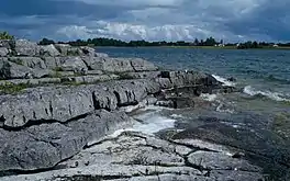
Lough Carra
Lough Carra (Irish: Loch Ceara)[2] is a limestone lake (marl)[1] of 4,000 acres (16 km2), in County Mayo, Ireland, about 8 miles (13 km) south of Castlebar. It is approximately 6 miles (9.7 km) long and varies in width from 400 yards (370 m) to one mile (1.6 km). The average depth is 6 feet (1.8 m), with a maximum of 60.[1] It drains into Lough Mask via the Keel River.
| Lough Carra | |
|---|---|
 | |
 Location in Ireland | |
| Location | County Mayo |
| Coordinates | 53°40′53″N 9°14′27″W |
| Native name | Loch Ceara (Irish) |
| Basin countries | Ireland |
| Max. length | 6 mi (9.7 km) |
| Max. width | 1 mi (1.6 km) |
| Surface area | 4,000 acres (16 km2) |
| Average depth | 6 feet (1.8 m) |
| Max. depth | 60 feet (18 m) |
| Islands | 73[1] |
Lough Carra was part of the estate of the well-known Moore family of Moore Hall.[3]
It is a well-known brown trout lough, and is situated northeast of Lough Mask.
Annalistic references
- AI688.1 Kl. Repose of Indlide, abbot of Cera, and of Diarmait, son of 'In Caech'. [AU —; AU 689].
Historical sites
See also
References
- Lough Carra Archived 2010-03-26 at the Wayback Machine descriptive document, loughcarra.org. Retrieved 2010-07-27.
- "Loch Ceara/Lough Carra". Placenames Database of Ireland (logainm.ie). Department of Culture, Heritage and the Gaeltacht and Dublin City University. Retrieved 14 March 2020.
- Moorehall and Lough Carra website. Retrieved 2010-07-27.
External links
- Moorehall and Lough Carra documentary
- Lough Carra website
- Article from Irish Fisheries
- Article from Mayo on the Move
- Video documentary filmed on Lough Carra
This article is issued from Wikipedia. The text is licensed under Creative Commons - Attribution - Sharealike. Additional terms may apply for the media files.