Louisiana Highway 21
Louisiana Highway 21 (LA 21) is a state highway in Louisiana that serves St. Tammany and Washington Parishes. It spans 51.76 miles (83.30 km) and is signed north and south.
Louisiana Highway 21 | ||||
|---|---|---|---|---|
 | ||||
| Route information | ||||
| Maintained by Louisiana DOTD | ||||
| Length | 52.1 mi[1] (83.8 km) | |||
| Existed | 1955 renumbering–present | |||
| Major junctions | ||||
| South end | ||||
| North end | ||||
| Location | ||||
| Country | United States | |||
| State | Louisiana | |||
| Highway system | ||||
| ||||
| ||||
.svg.png.webp)
Route description
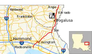
From the south, LA 21 begins at an intersection with LA 22 and LA 1077 in Madisonville, where LA 21 assumes the trajectory of LA 1077 and heads northeast. LA 1077 branches to the northwest before LA 21 intersects Interstate 12 (I-12). From south of I-12 and until joining U.S. Route 190 Business (US 190 Bus.) on 21st Avenue in Covington, LA 21 is multilaned, in places divided by a median or by a center turn lane, with some control of access.[1]
Through most of Covington, LA 21 is in a mostly two-lane undivided highway concurrent with US 190 Bus., which returns to US 190 on the east side of Covington—an area known as Claiborne Hill. After intersecting US 190 and before leaving Covington cosigned as Military Road, LA 21 absorbs LA 36 and continues northeastward, absorbing LA 59 and entering a brief concurrency with Louisiana Highway 40 in Bush for less than one mile (1.6 km). Between Bush and Sun, LA 21 widens to a four lane, divided highway after merging Louisiana Highway 41, continuing due north from the merge. In Sun LA 21 absorbs LA 16 and continues northward to Bogalusa, where LA 21 intersects LA 10. LA 21 then runs north through Varnado and Angie before becoming Mississippi Highway 35 at the state line.[1]
Major intersections
| Parish | Location | mi[1] | km | Destinations | Notes |
|---|---|---|---|---|---|
| St. Tammany | Madisonville | 0.0 | 0.0 | South end of LA 1077 overlap | |
| | 1.2 | 1.9 | North end of LA 1077 overlap | ||
| | 3.4– 3.6 | 5.5– 5.8 | I-12 exit 59 | ||
| Covington | 6.6 | 10.6 | South end of US 190 Bus. overlap | ||
| 7.8 | 12.6 | Interchange; westbound US 190 entrance only | |||
| 7.9– 8.0 | 12.7– 12.9 | North end of US 190 Bus. overlap | |||
| | 8.0– 8.1 | 12.9– 13.0 | Western terminus of LA 36 | ||
| | 11.9 | 19.2 | Southern terminus of LA 1082 | ||
| | 12.3 | 19.8 | Northern terminus of LA 59 | ||
| | 13.1 | 21.1 | Western terminus of LA 1084 | ||
| Waldheim | 15.2 | 24.5 | South end of LA 1083 overlap | ||
| 15.4 | 24.8 | North end of LA 1083 overlap | |||
| | 21.9 | 35.2 | South end of LA 40 overlap | ||
| | 22.4 | 36.0 | North end of LA 40 overlap | ||
| | 23.3 | 37.5 | Northern terminus of LA 41 | ||
| Sun | 25.5 | 41.0 | Eastern terminus of LA 16 | ||
| Washington | | 27.4 | 44.1 | Southern terminus of LA 1075 | |
| Bogalusa | 36.3 | 58.4 | |||
| | 38.8 | 62.4 | Terminus of LA 1082 | ||
| | 42.9 | 69.0 | |||
| Varnado | 44.0 | 70.8 | Western terminus of LA 436-1 | ||
| Angie | 48.9 | 78.7 | Western terminus of LA 1071 | ||
| 49.4 | 79.5 | Eastern terminus of LA 438 | |||
| | 52.1 | 83.8 | Mississippi state line | ||
1.000 mi = 1.609 km; 1.000 km = 0.621 mi
| |||||
References
- Google (April 15, 2019). "Louisiana Highway 21" (Map). Google Maps. Google. Retrieved April 15, 2019.