Lowry Hill Tunnel
The Lowry Hill Tunnel is a tunnel 1,496 feet (456 m) in length accommodating the Interstate 94 (I-94) freeway near downtown Minneapolis, Minnesota that was completed in late 1971. It is placed at a near-right-angle turn in the highway, forcing the three lanes of traffic in each direction to slow down. The advised speed is 40 miles per hour (64 km/h).
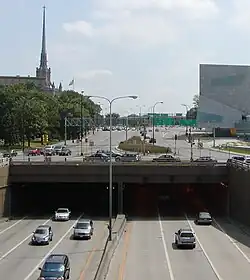 The entrance of Lowry Hill Tunnel from the north/west, below Hennepin and Lyndale Avenues | |
| Overview | |
|---|---|
| Location | Minneapolis, Minnesota |
| Coordinates | 44.96583°N 93.288217°W |
| Status | Open |
| Route | |
| Crosses | Local streets over Interstate 94 |
| Operation | |
| Opened | 1971 |
| Owner | Minnesota Department of Transportation (MnDOT) |
| Traffic | Automotive |
| Vehicles per day | 185,000 (2018)[1] |
| Technical | |
| Length | 1,496 ft (455 m)[2] |
| No. of lanes | 6 |
| Operating speed | 35 miles per hour (56 km/h) |

Although constructed as a tunnel through rock, the surface a few yards above is covered with roadways. The tunnel functions as if it were the underpass under a 0.25-mile-wide (400 m) bridge which carries Hennepin Avenue, Lyndale Avenue, and various ramps over I-94.
Opened in November 1971, this tunnel was built with $31 million to help fix the congestion of 30,000 vehicles a day. Today, the Lowry Hill Tunnel sees an average of 185,000 vehicles pass through it each day, 54% more than the Lincoln Tunnel[3] that connects New Jersey to Manhattan. The tunnel originally opened with two lanes in each direction, and since the shoulders have been replaced with third lanes due to demand. Despite massive increases in traffic, especially since the construction of I-394 on the 1990s and population growth of over 1 million people in the metropolitan area, the tunnel cannot be widened as it sits between the footings and basements of the Basilica on the East (a historic landmark), and the Walker Art Museum to the West.

References
- Rethinking I-94 | Phase 1 Report (PDF) (Report). Minnesota Department of Transportation. 2018.
- Minnesota Bridge Inventory 1955-1970 (PDF) (Report). Minnesota Department of Transportation. Archived from the original (PDF) on 12 April 2016.
- "2018 Monthly Traffic and Percent of E-ZPass Usage" (PDF). Archived from the original (PDF) on 2019-01-05. Retrieved 2019-01-05.