Pontiac, Quebec
Pontiac is a municipality in the Outaouais Region of western Quebec, Canada, on the north shore of the Ottawa River. It is part of Les Collines-de-l'Outaouais Regional County Municipality, included in the National Capital Region. It should not be confused with Pontiac Regional County Municipality, which is also in the Outaouais but not included in the National Capital Region.
Pontiac | |
|---|---|
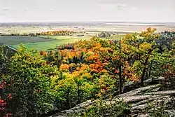
 Pontiac as seen from the Gatineau Hills | |
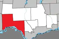
 Location within Les Collines-de-l'Outaouais RCM | |
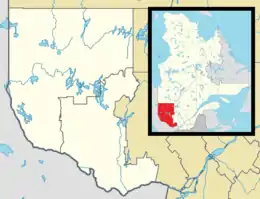
 Pontiac Location in western Quebec | |
| Coordinates: 45°35′N 76°08′W[1] | |
| Country | Canada |
| Province | Quebec |
| Region | Outaouais |
| RCM | Les Collines-de-l'Outaouais |
| Constituted | January 1, 1975 |
| Government | |
| • Mayor | Roger Larose |
| • Federal riding | Pontiac |
| • Prov. riding | Pontiac |
| Area | |
| • Total | 504.60 km2 (194.83 sq mi) |
| • Land | 445.27 km2 (171.92 sq mi) |
| Population (2021)[3] | |
| • Total | 6,142 |
| • Density | 13.8/km2 (36/sq mi) |
| • Pop 2016-2021 | |
| • Dwellings | 2,710 |
| Time zone | UTC−05:00 (EST) |
| • Summer (DST) | UTC−04:00 (EDT) |
| Postal code(s) | |
| Area Code | 819 |
| Highways | |
| Website | www |
It was created by the 1975 amalgamation of the municipalities of North Onslow, South Onslow, Quyon and Eardley, and named after the Odawa war chief Pontiac.[1]
Pontiac has a low cost of living and is trying to attract new immigrants coming to Canada to improve the local economy. A large portion of Gatineau Park is within this municipality.
Communities
- Beech Grove
- Breckenridge
- Eardley
- Heyworth
- Lusk
- Luskville
- Mohr
- North Onslow
- Onslow Corners
- Pontiac village
- Quyon
- Ruthledge
- Steel
- Wyman
History
The first European settlers in this area were Joseph Mondion and his family, who built a homestead in 1786 on what is known today as Indian Point. In 1800 his property was taken over by the XY Company, followed by the North West Company in 1804, and then the Hudson’s Bay Company in 1821, when these two companies merged. The HBC operated a small trading post, which closed in 1837.[5]
Onslow and Eardley Townships were already plotted on the Gale and Duberger Map of 1795, and it was early in the 19th century that these townships were opened to logging and settlement. One of the first settlements was on Pontiac Bay, founded by Philemon Wright and named at times Wright shanties, Pontiac Village, and Pontiacville. Quyon was founded in 1848 when a sawmill was built by John Egan at the mouth of the Quyon River.[5]
The Township Municipality of Onslow (likely named after George Onslow, 1st Earl of Onslow[6]) was formed in 1855, with John Behan as first mayor. In January 1875, Quyon village separated from Onslow to form its own municipality, and the following year, the township split into Onslow South (Onslow-Partie-Sud) and Onslow, renamed to Onslow North (Onslow-Partie-Nord) in 1878.[5]
Demographics
| 2021 | 2016 | 2011 | |
|---|---|---|---|
| Population | 6,142 (+5.0% from 2016) | 5,850 (3.0% from 2011) | 5,681 (8.5% from 2006) |
| Land area | 445.27 km2 (171.92 sq mi) | 448.15 km2 (173.03 sq mi) | 448.31 km2 (173.09 sq mi) |
| Population density | 13.8/km2 (36/sq mi) | 13.1/km2 (34/sq mi) | 12.7/km2 (33/sq mi) |
| Median age | 41.6 (M: 42, F: 40.8) | 41.9 (M: 42.4, F: 41.2) | 41.1 (M: 41.5, F: 40.8) |
| Private dwellings | 2,375 (total) | 2,664 (total) | 2,659 (total) |
| Median household income | $77,952 | $75,527 |
| Year | Pop. | ±% |
|---|---|---|
| 1986 | 3,955 | — |
| 1991 | 4,501 | +13.8% |
| 1996 | 4,722 | +4.9% |
| 2001 | 4,643 | −1.7% |
| 2006 | 5,238 | +12.8% |
| 2011 | 5,681 | +8.5% |
| 2016 | 5,850 | +3.0% |
| 2021 | 6,142 | +5.0% |
| Source: [3] | ||
According to the 2016 Canadian Census, the population's mother tongue was 55.5% French, 38.6% English, and 3.2% other languages, including Portuguese, German, Arabic, Spanish, Dutch, and Russian. Approximately 64.3% of people are bilingual, speaking both French and English.[12]
Local government
List of former mayors:[13]
- William Burke (1975–1979)
- Marcel Lavigne (1979–1990)
- Edward McCann (1990–1994)
- Marcel Lavigne (1994–1998)
- Bruce R. Campbell (1998–2005)
- Edward McCann (2005–2013)
- Roger Larose (2013–2017)
- Joanne Labadie (2017–2021)
- Roger Larose (2021–present)
References
- "Reference number 72506 in Banque de noms de lieux du Québec". toponymie.gouv.qc.ca (in French). Commission de toponymie du Québec.
- "Geographic code 82030 in the official Répertoire des municipalités". www.mamh.gouv.qc.ca (in French). Ministère des Affaires municipales et de l'Habitation.
- "Data table, Census Profile, 2021 Census of Population - Pontiac, Municipalité (MÉ) [Census subdivision], Quebec". 9 February 2022.
- "Archived copy" (PDF). Archived from the original (PDF) on 2016-03-04. Retrieved 2014-11-25.
{{cite web}}: CS1 maint: archived copy as title (link) - Maude-Emmanuelle Lambert. "History of the Municipality of Pontiac" (PDF). www.municipalitepontiac.com. Municipalité de Pontiac. Retrieved 6 December 2019.
- "Onslow (canton)" (in French). Commission de toponymie du Québec. Retrieved 2019-12-06.
- "2021 Community Profiles". 2021 Canadian Census. Statistics Canada. February 4, 2022. Retrieved 2022-04-27.
- "2016 Community Profiles". 2016 Canadian Census. Statistics Canada. August 12, 2021. Retrieved 2019-12-05.
- "2011 Community Profiles". 2011 Canadian Census. Statistics Canada. March 21, 2019. Retrieved 2019-12-05.
- "2006 Community Profiles". 2006 Canadian Census. Statistics Canada. August 20, 2019.
- "2001 Community Profiles". 2001 Canadian Census. Statistics Canada. July 18, 2021.
- "Pontiac, Quebec (Code 2482030) Census Profile". 2016 census. Government of Canada - Statistics Canada.
- Maude-Emmanuelle Lambert. "Maires et conseillers : l'engagement politique" (PDF). www.municipalitepontiac.com. Municipalité de Pontiac. Retrieved 6 December 2019.