M-209 (Michigan highway)
M-209 was a state trunkline highway in the Lower Peninsula of the US state of Michigan. It was located in Leelanau County in the Sleeping Bear Dunes National Lakeshore. Until it was decommissioned, it was Michigan's shortest state highway. M-209 started at M-109 and went just over 1⁄2 mile (about 956 yards [874 m]) to Glen Haven. In 1995, M-209's designation was "abandoned", and the road was turned over to the jurisdiction of the Leelanau County Road Commission.[1]
M-209 | ||||
|---|---|---|---|---|
| Glen Haven Road | ||||
M-209 highlighted in red | ||||
| Route information | ||||
| Maintained by MDOT | ||||
| Length | 0.543 mi[1] (874 m) | |||
| Existed | 1920s[2]–June 5, 1995[1] | |||
| Major junctions | ||||
| South end | ||||
| North end | Coast Guard Life Saving Station in Glen Haven | |||
| Location | ||||
| Country | United States | |||
| State | Michigan | |||
| Counties | Leelanau | |||
| Highway system | ||||
| ||||
Route description

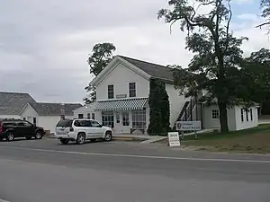
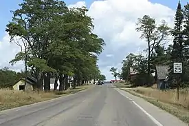
M-209 was the short connector route from M-109 to the Glen Haven unit of the Sleeping Bear Dunes National Lakeshore west of Glen Arbor.[3] The southern terminus of the highway was at the intersection with M-109 south of Glen Haven, a restored logging village on the shore of Lake Michigan on the Leelanau Peninsula. The roadway ran north from this intersection where M-109 made a 90–degree corner through the south and east legs of a four-way intersection with M-209 and Dune Valley Road. M-209 ran past such attractions as the restored General Store and Blacksmith Shop. Also located in Glen Haven is the former Glen Haven Canning Co. building. This building was first used as a warehouse and later as a cannery for cherries in the 1920s. It has since been restored as the Cannery Boathouse housing historic wooden boats used in the Manitou Passage between Glen Haven, Glen Arbor and the North and South Manitou islands.[4] The northern terminus of M-209 was located in front of the former US Coast Guard Life Saving Station, now restored as a maritime museum.[5] The museum is located at the intersection of Glen Haven Road and Sleeping Bear Dunes Road. At the time of decommissioning, M-209 was a two-lane, paved road.

Sleeping Bear Dunes National Lakeshore is a United States National Lakeshore located on the "little finger" of the Lower Peninsula of Michigan in Leelanau and Benzie counties. The park covers a 35-mile (56 km) stretch of Lake Michigan's eastern coastline, as well as North and South Manitou islands.[6] The park was authorized on October 21, 1970.[7]
History
From its inception in the 1920s, M-209 was Michigan's shortest highway.[2] It connected the small community of Glen Haven to M-109 just south of the community. Glen Haven was founded as a settlement called Sleeping Bearville with a sawmill[8] and an inn, the Sleeping Bear House, in 1857.[9] By 1881, there were 11 buildings in the community. The lifesaving station was built in 1901 and moved to its present location in 1931 before closing in 1941.[8]

M-209 was first assumed as a state trunkline in the 1920s.[2] A newspaper article in 1957 noted that that M-209 provided access to Sleeping Bear Dune, the country's largest moving sand dune. The article also noted that if it wasn't for the tourists visiting, that thee dune would probably have swallowed up the roadway that was "so small the road maps don't even show it".[10] It would later serve the national lakeshore when the park was created on October 21, 1970. The Park Service purchased all of the village by the mid-1970s. The highway was turned over to Leelanau County control on June 5, 1995.[1] It is now known only as Glen Haven Road.[11] Since the transfer, M-212 in Cheboygan County is now the shortest highway in the state.[12] A 1967 newspaper article noted that Business Spur Interstate 375 had opened that year and took the title as shortest highway in the state,[13] although that highway is not been signed.[14]
Major intersections
The entire highway was in Glen Arbor Township, Leelanau County.
| mi[1] | km | Destinations | Notes |
|---|---|---|---|
| 0.000 | 0.000 | ||
| 0.543 | 0.874 | Coast Guard station access road | |
| 1.000 mi = 1.609 km; 1.000 km = 0.621 mi | |||
See also
References
- State Administrative Board (February 20, 2007). "State Administrative Board Resolutions, 1940–Present". Lansing: State of Michigan. p. 45. OCLC 85834636. Retrieved January 1, 2023 – via Library of Michigan Digital Repository.
- Baird, Thomas (January 31, 2006). "Early Modern Highways in Leelanau". Leelanau Post. Archived from the original on July 4, 2008. Retrieved February 15, 2008.
- Michigan Department of Transportation (1995). Michigan Department of Transportation Map (Map). c. 1:918,720. Lansing: Michigan Department of Transportation. § G8. OCLC 42778335, 32885070. Retrieved October 17, 2019 – via Michigan History Center.
- National Park Service (n.d.). "Sleeping Bear Dunes National Lakeshore". National Park Service. Retrieved February 15, 2008.
- National Park Service (n.d.). "Sleeping Bear Dunes National Lakeshore: Maritime Museum". National Park Service. Retrieved February 15, 2008.
- Michigan Economic Development Corporation. "Sleeping Bear Dunes National Lakeshore". Pure Michigan. Michigan Economic Development Corporation. Retrieved June 20, 2014.
- United States Congress (October 21, 1970). "An Act to Establish in the State of Michigan the Sleeping Bear Dunes National Lakeshore, and for Other Purposes". Pub. L.Tooltip Public Law (United States) 91–479. Retrieved June 20, 2014.
- Weeks, George (2005). Sleeping Bear: Yesterday and Today (2nd ed.). Ann Arbor: University of Michigan Press. p. 208. ISBN 0472030310. OCLC 1049112703.
- Romig, Walter (1986). Michigan Place Names: The History of the Founding and the Naming of More than Five Thousand Past and Present Michigan Communities. Detroit: Wayne State University Press. p. 225. ISBN 9780814318386. OCLC 741733993.
- "Shortest Road in State Leads to Sleeping Bear". Battle Creek Enquirer. August 18, 1957. p. 4. Retrieved March 4, 2023 – via Newspapers.com.
- Google (February 15, 2008). "Glen Haven, MI" (Map). Google Maps. Google. Retrieved February 15, 2008.
- Girard, Jojo (September 28, 2021). "The Long and Short of It: Five Unique Michigan Highways". Grand Rapids, Michigan: WFGR-FM. Retrieved October 3, 2022.
- "US 23 and US 31 Longest Roads". The Homer Index. August 24, 1967. p. 5. Retrieved March 4, 2023 – via Newspapers.com.
- Michigan Department of Transportation (2020). Truck Operator's Map (Map). c. 1:221,760. Lansing: Michigan Department of Transportation. Detroit and Vicinity inset.
External links
- M-209 at Michigan Highways
