Maasvlakte 2
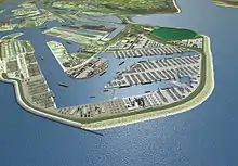
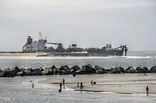
Maasvlakte 2 is a major civil engineering project in the Netherlands, constructing a new port and supporting infrastructure on reclaimed land adjoining the Maasvlakte. Approximately 2000 hectares will be reclaimed, behind a 4 km dike;[1] approximately 1000 hectares will be used by ports related industries.[2] It is an extension of the Port of Rotterdam.[3][4]


Maasvlakte 2 is the biggest civil engineering project in the Netherlands since the Delta Works.[5] The area opened on 22 May 2013.
Container terminal operators APM Terminals and Rotterdam World Gateway began construction of their terminals in 2012.[6] The APM terminal opened in April 2015.[7] Rotterdam World Gateway (RWG) is the main competitor for European Container Terminals (ECT), currently the biggest operator of a container terminal in Rotterdam. RWG's terminal includes a 20-meter deep dock and its own railroad station, and would be capable of handling 2.35 million containers annually.[8]
The Eurogeul was widened in anticipation of increased traffic.
Intermodal transport
Maasvlakte 2 takes advantage of Europoort's existing transport links; it is directly connected to the Betuwe Route.[9]
References
- "Maritime Journal - Dutch coastline redrawn as Maasvlakte 2 takes shape - by Peter Barker". Archived from the original on 2013-01-28. Retrieved 2010-10-31.
- "Maasvlakte 2 Landscape Plan - H+N+S Landschapsarchitecten". 2010-10-31. Retrieved 2010-10-31.
- "Port of Rotterdam Authority - Default". 2010-10-31. Archived from the original on 2010-11-03. Retrieved 2010-10-31.
- "Maasvlakte 2 - A New Part of the Port of Rotterdam" (PDF). 2010-07-20. Retrieved 2010-10-31.
- "The Netherlands: Young CEDA's Impressive Afternoon At Maasvlakte 2". Dredging Today. Retrieved 2011-04-01.
- Captein, Melvin (24 June 2012). "Tweede Maasvlakte eind 2013 in bedrijf". BNR Newsradio. Retrieved 25 June 2012.
- "APM Terminals Maasvlakte II Terminal Officially Opens". 25 April 2015. Retrieved 30 June 2015.
- "Bouw containerhaven Tweede Maasvlakte gaat door". Eindhovens Dagblad. 20 June 2012. Retrieved 25 June 2012.
- "Expansion of Rail Infrastructure and Transfer Capacity". Archived from the original on 2011-07-15. Retrieved 2010-10-31.