Macknade, Queensland
Macknade is a rural town and coastal locality in the Shire of Hinchinbrook, Queensland, Australia.[2][3] In the 2016 census, the locality of Macknade had a population of 229 people.[1]
| Macknade Queensland | |||||||||||||||
|---|---|---|---|---|---|---|---|---|---|---|---|---|---|---|---|
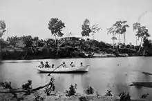
Transporting harvested sugarcane on a cane tramway to the sugar mill, 2008 | |||||||||||||||
 Macknade | |||||||||||||||
| Coordinates | 18.5766°S 146.2552°E | ||||||||||||||
| Population | 229 (2016 census)[1] | ||||||||||||||
| • Density | 3.418/km2 (8.852/sq mi) | ||||||||||||||
| Postcode(s) | 4850 | ||||||||||||||
| Area | 67.0 km2 (25.9 sq mi) | ||||||||||||||
| Time zone | AEST (UTC+10:00) | ||||||||||||||
| Location |
| ||||||||||||||
| LGA(s) | Shire of Hinchinbrook | ||||||||||||||
| State electorate(s) | Hinchinbrook | ||||||||||||||
| Federal division(s) | Kennedy | ||||||||||||||
| |||||||||||||||
Geography
Mackade is bounded by the Herbert River (18.5333°S 146.3°E)[4] on the south and east, the Seymour River (18.5166°S 146.2°E)[5] on the west and the Hinchinbrook Channel (18.4936°S 146.2496°E) to the north (separating the mainland from Hinchinbrook Island).[6]
Seaforth Channel is another off-shore passage (18.5151°S 146.2727°E).[7]
History
The Macknade Sugar Company opened a sugar plantation and the Macknade Sugar Mill in the area in 1874. The district took its name from the mill, which in turn took its name from a house in Kent, England where the mill's owners had lived.[8]
Macknade Provisional School opened on 13 November 1893. On 1 January 1909, it became Macknade State School.[9][10]
The postal receiving office opened in about 1901 and became a post office in October 1902. The post office closed on 29 October 1993.[11]
In the 2011 census, Macknade had a population of 304 people.[12]
In the 2016 census, the locality of Macknade had a population of 229 people.[1]
Economy
The Macknade Sugar Mill (18.5870°S 146.2567°E) is situated on the banks of the Herbert River .[13] It is the oldest raw sugar mill in Queensland. Its highest output was in 2005 when it crushed 1.82 million tonnes of sugar cane.[14]
The estuarine location of Macknade is well-suited for sugar growing, but it is also well-suited for aquaculture with Seafarms operating a large prawn-farming business on Neames Inlet Road (18.5323°S 146.2387°E).[15]
Education
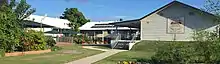
Macknade State School is a government primary (Prep-6) school for boys and girls at 79 Farrell Drive (18.5767°S 146.2518°E).[16][17] In 2018, the school had an enrolment of 26 students with 6 teachers (3 full-time equivalent) and 4 non-teaching staff (2 full-time equivalent).[18]
There is no secondary school in Macknade. The nearest government secondary school is Ingham State High School in Ingham to the south-west.[6]
See also
References
- Australian Bureau of Statistics (27 June 2017). "Macknade (SSC)". 2016 Census QuickStats. Retrieved 20 October 2018.
- "Macknade – town in Shire of Hinchinbrook (entry 20467)". Queensland Place Names. Queensland Government. Retrieved 20 July 2021.
- "Macknade – locality in Shire of Hinchinbrook (entry 42522)". Queensland Place Names. Queensland Government. Retrieved 20 July 2021.
- "Herbert River – watercourse in Shire of Hinchinbrook (entry 15762)". Queensland Place Names. Queensland Government. Retrieved 20 July 2021.
- "Seymour River – watercourse in Cassowary Coast Regional (entry 30534)". Queensland Place Names. Queensland Government. Retrieved 19 July 2021.
- "Queensland Globe". State of Queensland. Retrieved 23 December 2021.
- "Mountain ranges beaches and sea passages - Queensland". Queensland Open Data. Queensland Government. 12 November 2020. Archived from the original on 25 November 2020. Retrieved 25 November 2020.
- "Macknade". Queensland Places. Centre for the Government of Queensland, University of Queensland. Archived from the original on 24 May 2014. Retrieved 22 May 2014.
- Queensland Family History Society (2010), Queensland schools past and present (Version 1.01 ed.), Queensland Family History Society, ISBN 978-1-921171-26-0
- "Opening and closing dates of Queensland Schools". Queensland Government. Retrieved 22 May 2014.
- Premier Postal History. "Post Office List". Premier Postal Auctions. Archived from the original on 15 May 2014. Retrieved 22 May 2014.
- Australian Bureau of Statistics (31 October 2012). "Macknade (SSC)". 2011 Census QuickStats. Retrieved 22 May 2014.
- "Landmark Areas - Queensland". Queensland Open Data. Queensland Government. 18 November 2020. Archived from the original on 21 November 2020. Retrieved 21 October 2020.
- "Sucrogen: a sweet story in sugar and renewable energy" (PDF). Burdekin Shire Council. Archived (PDF) from the original on 16 March 2014. Retrieved 23 May 2014.
- "Seafarms operations". Seafarms.com.au. Archived from the original on 25 February 2021. Retrieved 25 February 2021.
- "State and non-state school details". Queensland Government. 9 July 2018. Archived from the original on 21 November 2018. Retrieved 21 November 2018.
- "Macknade State School". Macknade State School. 16 January 2020. Retrieved 23 December 2021.
- "ACARA School Profile 2018". Australian Curriculum, Assessment and Reporting Authority. Archived from the original on 27 August 2020. Retrieved 28 January 2020.
External links
- "Macknade". Queensland Places. Centre for the Government of Queensland, University of Queensland.