Shire of Mansfield
The Mansfield Shire is a local government area in the Hume region of Victoria, Australia, located in the north-east part of the state. It covers an area of 3,844 square kilometres (1,484 sq mi) and in June 2018, had a population of 8,979.[1]
| Mansfield Shire Victoria | |||||||||||||||
|---|---|---|---|---|---|---|---|---|---|---|---|---|---|---|---|
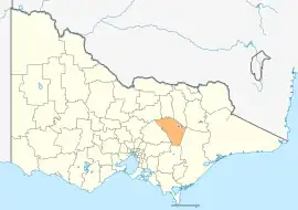 Location in Victoria | |||||||||||||||
| Population | 9,740 (2021)[1] | ||||||||||||||
| • Density | 2.5338/km2 (6.563/sq mi) | ||||||||||||||
| Established | 2002 | ||||||||||||||
| Gazetted | 17 October 2002[2] | ||||||||||||||
| Area | 3,844 km2 (1,484.2 sq mi)[1] | ||||||||||||||
| Mayor | Cr James Tehan | ||||||||||||||
| Region | Hume | ||||||||||||||
| State electorate(s) | Eildon | ||||||||||||||
| Federal division(s) | Indi | ||||||||||||||
| Website | Mansfield Shire | ||||||||||||||
| |||||||||||||||
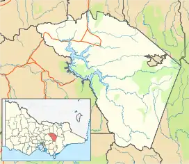
It includes the towns of Mansfield, Maindample, Mount Buller, Bonnie Doon, Jamieson, Kevington, Merrijig, Tolmie and Woods Point. It was formed in 2002 from the de-amalgamation of the Shire of Delatite into the current shire and the Rural City of Benalla.[2]
The de-amalgamation was the only successful de-amalgamation following the Kennett Government's policy of local government mergers. It was the result of organised political activity, with parallels to other autonomy movements.[3]
The Shire is governed and administered by Mansfield Shire Council; its seat of local government and administrative centre is located at the council headquarters in Mansfield. The Shire is named after the main urban settlement located in the north of the LGA, that is Mansfield, which is also the LGA's most populous urban centre with a population of 4,360.[4]
The Shire is bordered by the Rural City of Benalla, the Shire of Baw Baw, the Shire of Murrindindi, the Shire of Yarra Ranges, the Shire of Strathbogie and the Shire of Wellington. There are two unincorporated areas within the shire; the areas around Mount Buller and Mount Stirling.
Council
Current composition
The Shire has an unsubdivided structure, with five councillors elected to represent the community across the shire.
Administration and governance
The council meets in the council chambers at the council headquarters in the Mansfield Municipal Offices, which is also the location of the council's administrative activities. It also provides customer services at its administrative centre in Mansfield.
Townships and localities
The 2021 census, the shire had a population of 10,178 up from 8,584 in the 2016 census[6]
| Population | ||
|---|---|---|
| Locality | 2016 | 2021 |
| Ancona | 84 | 99 |
| Barjarg | 132 | 141 |
| Barwite | 228 | 269 |
| Bonnie Doon | 570 | 666 |
| Boorolite | 143 | 166 |
| Bridge Creek^ | 97 | 117 |
| Creek Junction^ | 16 | 34 |
| Delatite | 15 | 13 |
| Enochs Point^ | 0 | 3 |
| Gaffneys Creek | 10 | 3 |
| Goughs Bay | 261 | 328 |
| Howes Creek | 70 | 67 |
| Population | ||
|---|---|---|
| Locality | 2016 | 2021 |
| Howqua | 110 | 158 |
| Howqua Hills | 4 | 5 |
| Howqua Inlet | 56 | 63 |
| Jamieson | 301 | 382 |
| Kanumbra^ | 59 | 53 |
| Kevington | 43 | 36 |
| Knockwood | 0 | 0 |
| Lake Eildon | 7 | 3 |
| Macs Cove | 91 | 121 |
| Maindample | 212 | 239 |
| Mansfield | 4,787 | 5,541 |
| Matlock^ | 4 | 7 |
| Population | ||
|---|---|---|
| Locality | 2016 | 2021 |
| Merrijig | 549 | 721 |
| Merton^ | 190 | 216 |
| Mirimbah^ | * | 0 |
| Mount Buller^ | 243 | 333 |
| Mountain Bay | 43 | 54 |
| Piries | 58 | 66 |
| Reynard^ | 0 | 0 |
| Sawmill Settlement | 88 | 86 |
| Tolmie^ | 447 | 547 |
| Woods Point | 37 | 33 |
| Woodfield | 36 | 62 |
^ - Territory divided with another LGA
* - Not noted in 2016 Census
See also
References
- {{cite web|title=3218.0 – Regional Population Growth, Australia, 2017-18: Population Estimates by Local Government Area, 2021 |url=https://profile.id.com.au/mansfield/population-estimate%7Cwebsite=Estimated Resident Population|publisher=[[Profile ID]|date=27 June 2022|access-date=27 June 2022}} Estimated resident population, 30 June 2021.
- Victoria Government Gazette – Online Search (17 October 2002). "G42 of 2002: Order estg the Rural City of Benalla and Shire of Mansfield" (PDF). Victoria Government Gazette. State Government of Victoria. pp. 85–97. Retrieved 10 January 2014.
- Chen, Peter. "'They are not like us'". University of Melbourne. University of Melbourne. Retrieved 13 December 2018.
- Census QuickStats (2011). "Mansfield (SS) – SSC20844". Australian Bureau of Statistics. Government of Australia. Retrieved 10 January 2014.
- "Meet Your Councillors | Mansfield Shire Council".
- "Census | Australian Bureau of Statistics". www.abs.gov.au. 11 January 2023.
External links
- Mansfield Shire Council official website
- Metlink local public transport map
- Link to Land Victoria interactive maps
Localities in the Shire of Mansfield | ||
|---|---|---|
| Town |
|  |
| Locality |
| |
^ - Territory divided with another LGA | ||