Manuʻa Islands
The Manuʻa Islands,[1][2][3] or the Manuʻa tele (Samoan: Manuʻa tele), in the Samoan Islands, consists of three main islands: Taʻū, Ofu and Olosega.[4][5][6] The latter two are separated only by the shallow, 137-meter-wide Āsaga Strait, and are now connected by a bridge over the strait. The islands are located some 110 kilometers (68 miles) east of Tutuila and are a part of American Samoa, an unincorporated territory of the United States. Their combined area is 56 square kilometers (22 square miles), and they have a total population of 1,400. Taʻu is the largest of these islands, with an area of 44 km2 (17 sq mi), and it has the highest point of the Manuʻa, at 931 meters (3,054 feet). Politically, the islands form the Manuʻa District, one of the three administrative divisions of American Samoa.
Native name: Manuʻa tele | |
|---|---|
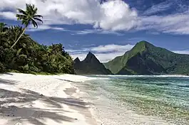
 The Islands of Ofu and Olosega viewed from the village of Sili along the north shore of Olosega. The middle peak is Sunuʻitao on Ofu, across the narrow strait at Asaga from Olosega (foreground and mountain on left) | |
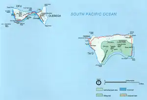
 Map of the Manu'a islands | |
| Geography | |
| Location | Pacific Ocean |
| Coordinates | 14°12′31″S 169°33′10″W |
| Archipelago | Samoan Islands |
| Area | 56 km2 (22 sq mi) |
| Highest elevation | 931 m (3054 ft) |
| Administration | |
United States | |
| Territory | American Samoa |
| Demographics | |
| Population | 1,400 |

Manu'a was the political centre of the region for many centuries, until the rise of the Tu'i Tonga maritime empire, which led to a shift in power from the eastern islands of Samoa to its western islands.
Geography
All three islands are volcanic islands: volcanic remnants rising out of the sea 14° south of the equator. The islands are elevated and mountainous.[7] In contrast to most places in the world, the population of these islands has been decreasing steadily for decades. In the 1930s some 20% of the population of American Samoa lived in the Manuʻa Islands. By the 1980s, only 6% were located there. Emigration is the consequence of a lack of economic opportunities and a desire of young people to participate in the more modern lifestyle offered on Tutuila (Office of Tourism, 2005). All the land of Manuʻa is owned communally by Samoan families of Manuʻa. This includes the National Parks lands which are only leased to the US National Parks system for 50 years.
History
According to historical Samoan oral tradition, Manu'a was formerly the ruling center of a large Polynesian empire that included the entire Samoan archipelago, as well as other nearby islands, including Tonga and Fiji.[8] The traditional capital of Manuʻa is the village of Taʻū, on the island of Taʻū.
The Tui Manu'a
The sovereign of Manuʻa was traditionally called “Tui Manuʻa,” This title was the progenitor of many of the high titles used in other parts of the Samoan Islands. Manuʻa was the only part of Samoa that was never subjected to Tongan rule, because both the Tongans and the Samoans regarded Manuʻa as having sacred status. The last Tui Manuʻa was Tuimanuʻa Elisara (sometimes written Tui Manuʻa Elisala), who held the title at the beginning of the 20th century. Before he died on July 2, 1909, he expressed the wish that the title die with him. At the time, the U.S. government took the position that Elisara's title had actually changed to “District Governor” nine years before his death, on June 5, 1900, the day that the U.S. flag had been hoisted at Taʻū (Office of the Governor, 2004). However, titles and holdings were not obliterated when the islands became a U.S. territory, and the title and estates of Tuimanuʻa remain in the custody of the Anoalo clan (the male Tuimanuʻa line). So the title Tui Manuʻa technically still exists, although no one is the holder of the title.
Below is a list of the names of the known Tui Manu'a: 41 successive generations of title holders, spanning over 2,000 years. Note: these aren't all the title holders.
01) Tui Manu’a Satiailemoa
02) Tui Manu’a Tele or Fitiaumua
03) Tui Manu’a Maugaotele
04) Tui Manu’a Tae O Tagaloa or Folasa
05) Tui Manu’a Fa’aeanu’u or Fa’atutupunu’u
06) Tui Manu’a Saoioiomanu
07) Tui Manu’a Saopu’u
08) Tui Manu’a Saoloa
09) Tui Manu’a Tu’ufesoa
10) Tui Manu’a Letupua
11) Tui Manu’a Saofolau
12) Tui Manu’a Saoluaga
13) Tui Manu’a Lelologatele
14) Tui Manu’a Alia Matua
15) Tui Manu’a Alia Tama
16) Tui Manu’a Ti’aligo
17) Tui Manu’a Fa’aeanu’u II
18) Tui Manu’a Puipuipo
19) Tui Manu’a Siliaivao
20) Tui Manu’a Manufili
21) Tui Manu’a Fa’atoalia Manu-O-Le-Fale-Tolu
22) Tui Manu’a Segisegi
23) Tui Manu’a Siliave
24) Tui Manu’a Pomelea
25) Tui Manu’a Lite or Tui Aitu
26) Tui Manu’a Toalepa’i
27) Tui Manu’a Seuea
28) Tui Manu’a Salofi
29) Tui Manu’a Levaomana or Lemamana
30) Tui Manu’a Taliutafa Pule
31) Tui Manu’a Ta’alolomanu Moaatoa
32) Tui Manu’a Tupalo
33) Tui Manu’a Seiuli
34) Tui Manu’a U’uolelaoa
35) Tui Manu’a Fagaese
36) Tui Manu’a Tauveve
37) Tui Manu’a Tauilima
38) Tui Manu’a Alalamua
39) Tui Manu’a Makerita
40) Tui Manu’a Elisala – Officially the last Tui Manu’a; died in 1909
41) Tui Manu’a Kilisi Taliutafa – Revived the Tui Manu’a title in 1924, but never fully took office.

US Cession

The Tripartite Convention of 1899 partitioned the Samoan Islands, giving the U.S. control of the eastern islands (including Tutuila and the Manuʻa Group), and giving European powers control of the western islands (including ʻUpolu and Savaiʻi).
In 1901, Tutuila's leaders agreed to this arrangement. As a result, Manu'a was eventually forced to accept U.S. rule, and they formalized their acceptance in a Deed of Succession, signed by the Tui Manuʻa (supreme chief of Manuʻa) on July 16, 1904. The signing took place at the Crown residence of the Tuimanuʻa (called the Faleula) in Lalopua (according to official documents of the Tuimanuʻa government (Office of the Governor, 2004). Around this time, as of 1903, Manu'a had a total population of approximately 2,000 residents.[9]
Since that time, the Manuʻa Island Group has officially been part of the US Protectorate of American Samoa.
In 1915, in response to the destruction caused to Manu'a that year by a hurricane, both the U.S. Congress and the American Red Cross sent financial aid to American Samoa for the first time.[10]
Society and culture

The history of Manuʻa is said in Samoan oratory to contain the origins of Samoan and Polynesian culture, and the genealogy of Polynesians east of Samoa is said to have originated in Manuʻa. In traditional belief the sun rises over Samoa at Saua on the island of Taʻū, where the coral reef is supposed to be always yellow from the sun, and it sets at Falealupo the westernmost village on the island of Savaiʻi in Samoa. This journey of the sun is strongly related to traditional beliefs and defines the uniformity of cultural identity across both Samoas. The term Fa'asamoa describes "The Samoan Way", or traditional Samoan way of life
Economy
Today, many families of Manuʻa rely on income from family members working in Tutuila and in the United States. The local diet is generally healthier than in Tutuila, with less reliance on imported American and New Zealand tinned foods, and a greater reliance on local fishing and farming.
Language
The people of Manuʻa speak the Samoan language and utilize the "t".
Education
The high school on Taʻū, called Manuʻa High School, serves all of Manuʻa. Most students seeking higher education go to American Samoa Community College in Tutuila or National University of Samoa on ʻUpolu, or as far away as the University of Hawaiʻi and elsewhere.
References
- https://www.britannica.com/place/Manua-Islands Britannica.com. Manua Islands. Retrieved July 4, 2020.
- https://www.nps.gov/npsa/learn/historyculture/nameeson-land.htm U.S. National Park Service. National Park of American Samoa. Names Upon the Land. Retrieved July 4, 2020.
- https://www.lonelyplanet.com/american-samoa/manua-islands Lonely Planet. Manu'a Islands. Retrieved July 4, 2020.
- Hills, J.W. (2010). O upu muamua i le Tala i le Lalolagi mo e ua faatoa aʻoaʻoina u lea mataupu: Elementary Geography. Nabu Press. Page 62. ISBN 9781147952896.
- Gupta, Alok K. (1998). Igneous Rocks. Allied Publishers. Page 382. ISBN 9788170237846.
- Shaffer, Robert J. (2000). American Samoa: 100 Years Under the United States Flag. Island Heritage. Page 210. ISBN 9780896103399.
- Hills, J.W. (2010). O upu muamua i le Tala i le Lalolagi mo e ua faatoa a'oa'oina u lea mataupu: Elementary Geography. Nabu Press. Page 62. ISBN 9781147952896.
- E. E. V. Collocott. "Journal of the Polynesian Society: An Experiment In Tongan History, By E. E. V. Collocott, P 166-184". jps.auckland.ac.nz.
- Hills, J.W. (2010). O upu muamua i le Tala i le Lalolagi mo e ua faatoa a'oa'oina u lea mataupu: Elementary Geography. Nabu Press. Page 64. ISBN 9781147952896.
- Shaffer, Robert J. (2000). American Samoa: 100 Years Under the United States Flag. Island Heritage. Page 145. ISBN 9780896103399.
- McMullin, Dan. 2005. "The Passive Resistance of Samoans to US and Other Colonialisms", article in Sovereignty Matters , University of Nebraska Press.
- Office of the Governor. 2004. Manuʻa ma Amerika. A brief historical documentary. Manuʻa Centennial. 16 July 1904. 16 July 2004. Office of the Governor, American Samoa Government. 20 p.
- Office of Tourism. 2005. The Manuʻa Islands. Office of Tourism, Dept. of Commerce, Government of American Samoa (pamphlet).