Maple River (Minnesota)
The Maple River is an 80.3-mile-long (129.2 km)[1] tributary of the Le Sueur River in southern Minnesota in the United States.[2] Via the Le Sueur, Blue Earth and Minnesota rivers, it is part of the watershed of the Mississippi River.

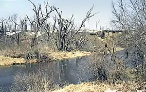
The Maple River near Mapleton
The river received its name from the groves of maple trees lining its banks.[3]
Course
The Maple River flows from Penny Lake in northwestern Freeborn County and initially follows a generally northwestward course through northeastern Faribault and southern Blue Earth counties. It turns northward in Blue Earth County and passes the town of Good Thunder. It joins the Le Sueur River from the south, about 6 miles (10 km) south of Mankato.
See also
References
- U.S. Geological Survey. National Hydrography Dataset high-resolution flowline data. The National Map Archived 2012-03-29 at the Wayback Machine, accessed October 5, 2012
- U.S. Geological Survey Geographic Names Information System: Maple River
- Upham, Warren (1920). Minnesota Geographic Names: Their Origin and Historic Significance. Minnesota Historical Society. p. 188.
This article is issued from Wikipedia. The text is licensed under Creative Commons - Attribution - Sharealike. Additional terms may apply for the media files.