Maroa Caldera
The Maroa Caldera (Maroa Volcanic Centre) is approximately 16 km × 25 km (9.9 mi × 15.5 mi) in size and is located in the north-east corner of the earlier Whakamaru caldera in the Taupō Volcanic Zone in the North Island of New Zealand.
| Maroa Caldera | |
|---|---|
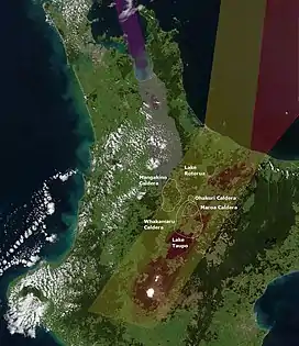 Maroa Caldera approximate location and boundaries contained within the older Whakamaru Caldera. The Ohakuri Caldera which had a paired eruption with the Rotorua Caldera is to its north and was not recognised as a separate caldera historically. To its west is the oldest Mangakino Caldera of the old Taupō Rift (yellow shading). Also shown is the modern Taupō Rift (red shading), Hauraki Rift (purple shading) and landmarks of Lake Taupō and Lake Rotorua | |
| Highest point | |
| Peak | Maroanui |
| Elevation | 897 m (2,943 ft) |
| Coordinates | 38°31′11″S 176°01′19″E |
| Dimensions | |
| Length | 25 km (16 mi)[1] |
| Width | 16 km (9.9 mi)[1] |
| Geography | |
| Country | New Zealand |
| Region | Waikato |
| Range coordinates | 38°25′12″S 176°4′48″E |
| Geology | |
| Age of rock | |
| Mountain type | Caldera |
| Volcanic region | Taupō Volcanic Zone |
| Last eruption | 14,000 years ago[1] |
| Climbing | |
| Access | State Highway 1 (New Zealand) |
Geography
Its northern rim is to the south of the Waikato River at Ātiamuri. At Ātiamuri the Ohakuri Caldera which had a paired eruption with the Rotorua Caldera is to its immediate north. The eastern boundary is also defined by the present Waikato River and it extends as far south as probably opposite Orakei Korako on the river. The southern boundary is somewhat ill defined given the subsequent deep deposits from the Taupō Volcano but includes a number of domes of which the highest is Maroanui at 897 metres (2,943 ft).
Eruptive history
The Maroa Caldera's last major eruption produced 140 km3 (33.6 cu mi) of tephra about 230,000 years ago (230 ka).[2] Its earliest eruption was about 300 ka with decreasing frequency and volume to as recently as 16.5ka[3] when an eruption of about 0.25 km3 (0.1 cu mi) occurred from the Puketarata volcanic complex (38°33′02″S 176°03′16″E to distinguish from another older volcano of this name near Te Kawa).[3][4] The caldera is now mainly dome lava in filled.[1] In summary going back in time: [1]
- 16,500 years ago Puketarata tuff ring formed with total volume of 0.25 km3 (0.060 cu mi)[4] in a complex series of eruptions including maar formation[3]
- 229,000 to 196,000 Pukeahua deposits and dome building
- 220,000 unclear where Mokai ignimbrite that outcrop in some of Maroa area comes from
- 229,000 ± 12,000 Ātiamuri deposits from northern Maroa
- 251,000 ± 17,000 onward two large parallel dome complexes developed
- 256,000 ± 12,000 Orakonui pyroclastics from a central Maroa source
- 272,000 ± 10,000 Putauaki pyroclastics from a central Maroa source
- 275,000 to 240,000 years ago small-scale pyroclastic eruptions
- 283,000 ± 11,000 Korotai deposits from northern Maroa
- 305,000 ± 17,000 oldest Maroa dome
References
- Leonard, Graham S. (2003). The evolution of Maroa Volcanic Centre, Taupō Volcanic Zone, New Zealand (Thesis). University of Canterbury. Retrieved 2022-05-15.
- "Supplementary Table to P.L. Ward, Thin Solid Films (2009) Major volcanic eruptions and provinces" (PDF). Teton Tectonics. Retrieved 2010-03-16.
- Kósik, S.; Németh, K.; Lexa, J.; Procter, J.N. (2019). "Understanding the evolution of a small-volume silicic fissure eruption: Puketerata Volcanic Complex, Taupo Volcanic Zone, New Zealand". Journal of Volcanology and Geothermal Research. 383: 28–46. doi:10.1016/j.jvolgeores.2017.12.008. ISSN 0377-0273. S2CID 134914216.
- Brooker, M. R.; Houghton, B. F.; Wilson, C. J. N.; Gamble, J. A. (1993). "Pyroclastic phases of a rhyolitic dome-building eruption: Puketarata tuff ring, Taupo Volcanic Zone, New Zealand". Bulletin of Volcanology. 55 (6): 395–406. doi:10.1007/BF00301999. S2CID 129649708.