Marolambo (district)
Marolambo is a district of Atsinanana in Madagascar.[1][2]
Marolambo District | |
|---|---|
 Marolambo District Location in Madagascar | |
| Coordinates: 20°03′S 48°07′E | |
| Country | |
| Region | Atsinanana |
| District | Marolambo District |
| Time zone | UTC3 (EAT) |
| Postal code | 513 |
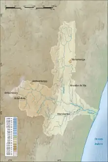
location map of Marolambo
Rivers
The Nosivolo River, an affluent of the Mangoro River.
Nature
Access
Marolambo is of difficult acces, most of the year only tractors pass the unpaved National road 23 of 130 km from Mahanoro.[4]
References
- REPOBLIKAN’I MADAGASIKARA:Tanindrazana – Fahafahana – Fandrosoana (PDF). MINISTERE DE L’AGRICULTURE, DE L’ELEVAGE ET DE LA PECHE. October 2007. pp. 42–44. Archived from the original (PDF) on 2018-06-12. Retrieved 2018-06-09.
- "Madagascar: Administrative Division". citypopulation. Retrieved 10 June 2018.
- Marolambo National Park
- Marolambo s'ouvre au monde
Capital: Toamasina | ||
| Antanambao Manampotsy - 507 | 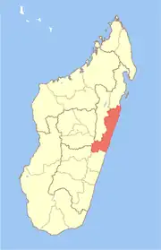 | |
| Mahanoro - 510 | ||
| Marolambo - 513 | ||
| Toamasina I - 501 | ||
| Toamasina II - 502 | ||
| Vatomandry - 517 | ||
| Vohabinany (Brickaville) - 508 | ||
7 districts; 75 communes | ||
This article is issued from Wikipedia. The text is licensed under Creative Commons - Attribution - Sharealike. Additional terms may apply for the media files.