Maronne
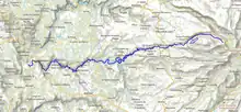
The Maronne (French pronunciation: [maʁɔn]) is a 92.6-kilometre (57.5 mi) long river in the Cantal and Corrèze departments in south central France.[1] Its source is several small streams joining near Récusset, a hamlet in Saint-Paul-de-Salers. It flows generally west. It is a left tributary of the Dordogne, into which it flows between Argentat and Monceaux-sur-Dordogne.
| Maronne | |
|---|---|
 | |
 | |
| Location | |
| Country | France |
| Physical characteristics | |
| Source | |
| • location | Saint-Paul-de-Salers |
| • coordinates | 45°08′32″N 02°35′44″E |
| • elevation | 1,050 m (3,440 ft) |
| Mouth | |
• location | Dordogne |
• coordinates | 45°04′21″N 01°55′39″E |
• elevation | 165 m (541 ft) |
| Length | 92.6 km (57.5 mi) |
| Basin size | 821 km2 (317 sq mi) |
| Discharge | |
| • average | 20.3 m3/s (720 cu ft/s) |
| Basin features | |
| Progression | Dordogne→ Gironde estuary→ Atlantic Ocean |
Departments and communes along its course
This list is ordered from source to mouth:
- Cantal: Saint-Paul-de-Salers, Fontanges, Saint-Martin-Valmeroux, Sainte-Eulalie, Besse, Pleaux, Saint-Martin-Cantalès, Arnac,
- Corrèze: Saint-Julien-aux-Bois
- Cantal: Cros-de-Montvert,
- Corrèze: Saint-Cirgues-la-Loutre,
- Cantal: Rouffiac,
- Corrèze: Saint-Geniez-ô-Merle, Goulles, Saint-Bonnet-les-Tours-de-Merle, Sexcles, Hautefage, Mercœur, La Chapelle-Saint-Géraud, Argentat and Monceaux-sur-Dordogne
This article is issued from Wikipedia. The text is licensed under Creative Commons - Attribution - Sharealike. Additional terms may apply for the media files.