Maryland Route 935
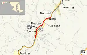
Maryland Route 935 (MD 935) is an unsigned state highway in the U.S. state of Maryland. The state highway runs 2.99 miles (4.81 km) from MD 36 in Barton north to MD 36 in Nikep. MD 935 is the old alignment of MD 36 through Barton, Moscow, and Nikep in the Georges Creek Valley of western Allegany County. The state highway was designated when MD 36 moved to a new alignment through the communities in the early 1980s.
Maryland Route 935 | ||||
|---|---|---|---|---|
 | ||||
| Route information | ||||
| Maintained by MDSHA | ||||
| Length | 2.99 mi[1] (4.81 km) | |||
| Existed | 1982–present | |||
| Major junctions | ||||
| South end | ||||
| North end | ||||
| Location | ||||
| Country | United States | |||
| State | Maryland | |||
| Counties | Allegany | |||
| Highway system | ||||
| ||||
Route description
_between_Potomac_Hollow_Road_and_Water_Street_in_Barton%252C_Allegany_County%252C_Maryland.jpg.webp)
MD 935 begins at an intersection with MD 36 (New Georges Creek Road) just south of Barton. The state highway heads west as a two-lane undivided road, then turns north at the following intersection with Lower Georges Creek Road, which heads south as a county-maintained portion of old MD 36. MD 936 heads north as Lower Georges Creek Road. The state highway's name changes to Legislative Road on crossing Moores Run and entering the town limits of Barton. MD 935 crosses Georges Creek and turns west. The state highway turns north again at Railroad Street and parallels the Georges Creek Railway through the business district of Barton. MD 935 turns northwest and crosses the railroad, then turns northeast to cross Butcher Run. Takoma Drive, an old alignment, splits to the east shortly before the state highway leaves the town of Barton. MD 935 continues north as Lower Georges Creek Road through the community of Moscow, where the state highway crosses Georges Creek a second time and closely parallels the railroad. A short unnamed highway, MD 935A, connects MD 935 and MD 36 within Moscow. MD 935 crosses Georges Creek a third time and passes through Nikep, where an old alignment parallels the highway, before reaching its northern terminus at MD 36 (Lower Georges Creek Road).[1][2]
History
MD 935 is the old alignment of MD 36 through Barton, Moscow, and Nikep. The highway was paved from Nikep toward Lonaconing by 1910.[3] The road south of the center of Barton was paved by 1915.[4] The highway from Barton north through Moscow to Nikep was under construction at that time and completed by 1919.[4][5] MD 36's bypass of Barton, Moscow, and Nikep was completed around 1982, at which time MD 935 was assigned to the old road through the communities.[6]
Junction list
The entire route is in Allegany County.
| Location | mi[1] | km | Destinations | Notes | |
|---|---|---|---|---|---|
| Barton | 0.00 | 0.00 | Southern terminus | ||
| Nikep | 2.99 | 4.81 | Northern terminus | ||
| 1.000 mi = 1.609 km; 1.000 km = 0.621 mi | |||||
Auxiliary route
MD 935A is the unsigned designation for a 0.10-mile (0.16 km) connector road between MD 935 and MD 36 in Moscow.[1][7]
See also
References
- Highway Information Services Division (December 31, 2013). Highway Location Reference. Maryland State Highway Administration. Retrieved 2010-11-05.
- Allegany County (PDF).
- Google (2010-06-17). "Maryland Route 935" (Map). Google Maps. Google. Retrieved 2010-06-17.
- Maryland Geological Survey (1910). Map of Maryland (PDF) (Map). Baltimore: Maryland Geological Survey.
- Weller, O.E.; Parran, Thomas; Miller, W.B.; Perry, John M.; Ramsay, Andrew; Smith, J. Frank (May 1916). Annual Reports of the State Roads Commission of Maryland (1912–1915 ed.). Baltimore: Maryland State Roads Commission. pp. 122, 128. Retrieved 2010-11-05.
- Zouck, Frank H.; Uhl, G. Clinton; Mudd, John F. (January 1920). Annual Reports of the State Roads Commission of Maryland (1916–1919 ed.). Baltimore: Maryland State Roads Commission. p. 18. Retrieved 2010-11-05.
- "Traffic Volume Map" (PDF). Maryland State Highway Administration. 1982. Retrieved 2010-11-05.
- Google (2010-06-17). "Maryland Route 935A" (Map). Google Maps. Google. Retrieved 2010-06-17.
