Massa (river)
The Massa (German pronunciation: [ˈmasa]) is a seven kilometre long river in the eastern Bernese Alps in the Swiss canton of Valais. It is mainly fed by the melt-water from the Aletsch Glacier.[1] It passes through the Massa Gorge and flows into the Stausee Gibidum reservoir and onwards to its confluence with the Rhône.
| Massa | |
|---|---|
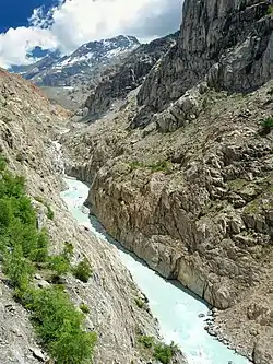 The Massa flows through a steep sided gorge. In the distance is the Aletsch Glacier, which sources the melt-water. | |
| Location | |
| Country | Switzerland |
| Physical characteristics | |
| Source | Aletsch Glacier |
| • location | Valais |
| • coordinates | 46°26′32″N 8°04′38″E |
| Mouth | Rhône |
• location | Bitsch, Valais |
• coordinates | 46.3298°N 8.0129°E |
| Length | 7 km (4.3 mi) |
| Basin features | |
| Progression | Rhône→ Mediterranean Sea |
The whole area, including other glaciers is part of the Jungfrau-Aletsch Protected Area, which was declared a UNESCO World Heritage Site in 2001.
See also
Wikimedia Commons has media related to Massa river.
References
- The Massa on the National Map of Switzerland
- "Earth From Space: Aletsch Glacier, Swiss and Italian Alps". SpaceRef. 26 January 2015. Retrieved 10 February 2021.
This article is issued from Wikipedia. The text is licensed under Creative Commons - Attribution - Sharealike. Additional terms may apply for the media files.