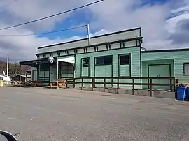
Mathinna, Tasmania
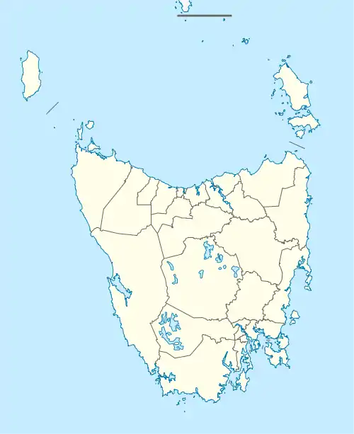
Mathinna is a rural locality in the local government areas (LGA) of Break O'Day (97%) and Dorset (3%) in the North-east LGA region of Tasmania. The locality is about 83 kilometres (52 mi) south-west of the town of St Helens. The 2016 census recorded a population of 142 for the state suburb of Mathinna.[1]
| Mathinna Tasmania | |||||||||||||||
|---|---|---|---|---|---|---|---|---|---|---|---|---|---|---|---|
 | |||||||||||||||
 Mathinna | |||||||||||||||
| Coordinates | 41°28′36.6″S 147°53′19.0″E | ||||||||||||||
| Population | 131 (2021 census)[1] | ||||||||||||||
| • Density | 0.2/km2 (0.52/sq mi) | ||||||||||||||
| Postcode(s) | 7214 | ||||||||||||||
| Elevation | 300 m (984 ft) | ||||||||||||||
| Area | 1,370.4 km2 (529.1 sq mi) | ||||||||||||||
| Location |
| ||||||||||||||
| LGA(s) | Break O'Day Council | ||||||||||||||
| Region | North-east | ||||||||||||||
| State electorate(s) | Lyons | ||||||||||||||
| Federal division(s) | Lyons | ||||||||||||||
| |||||||||||||||
It is a small Australian town in the north-east of Tasmania, 63 km east of Launceston. It was named after a young Aboriginal girl sent to live with the Lieutenant Governor of Van Diemen's Land, Sir John Franklin and his wife, Lady Jane Franklin.[2]
History
Mathinna was gazetted as a locality in 1976.[3]
The town became established as a gold mining centre, shortly after gold was discovered in the area in the 1890s. The Golden Gate Mine in Mathinna was one of Tasmania's highest-yield gold mines, second only to Beaconsfield. At its peak in the late 1890s, the town sustained a population of over 5,000, including a large number of Chinese miners, making it the third largest town in Tasmania at the time.[4] Melbourne-based mining company Riltec made a failed attempt to re-establish the Golden Gate mine in 1994,[5] although recent gold mining efforts have been more successful, with a production target of 70,000 ounces made for the Mathinna mine in 2006.[6]
Blackboy Post Office opened on 30 June 1870, was renamed Reedy Marsh, Blackboy in 1871 and Mathinna in 1882.[7]
Former Premier of Tasmania Eric Reece, was born in the town in 1909.[8]
Geography
The Scamander River forms part of the northern and most of the north-eastern boundaries.[9]
Road infrastructure
Route B43 (Mathinna Road) enters from the south and runs north-west and west to the village. From there, the road continues west as C401 (Upper Esk Road).[3][10]
References
- "2021 Census Quick Stats Mathinna (Tas.)". quickstats.censusdata.abs.gov.au. Australian Bureau of Statistics. 26 July 2022. Retrieved 26 July 2022.
- "Mathinna (1835 - 1856) Tasmanian Aboriginal".
- "Placenames Tasmania – Mathinna". Placenames Tasmania. Select “Search”, enter "1114H", click “Search”, select row, map is displayed, click “Details”. Retrieved 2 April 2021.
- Community History - Mathinna Archived 2007-07-16 at the Wayback Machine, Fingal Online Access Centre (Tasmanian Communities Online). Retrieved on 27 May 2007.
- Making a Nation - About Mathinna, The Examiner. Retrieved on 27 May 2007.
- Gold exploration ramping up in state's north east, Australian Broadcasting Corporation, 29 May 2006. Retrieved on 27 May 2007.
- Phoenix Auctions History. "Post Office List". Phoenix Auctions. Retrieved 21 March 2021.
- "Eric Elliott Reece". Members of the Parliament of Tasmania. Retrieved 25 August 2022.
- Google (2 April 2021). "Mathinna, Tasmania" (Map). Google Maps. Google. Retrieved 2 April 2021.
- "Tasmanian Road Route Codes" (PDF). Department of Primary Industries, Parks, Water & Environment. May 2017. Archived from the original (PDF) on 1 August 2017. Retrieved 2 April 2021.