Matrouh Governorate
Matrouh Governorate (Arabic: محافظة مطروح Muḥāfaẓat Maṭrūḥ) is one of the governorates of Egypt. Located in the north-western part of the country, it borders Libya. Its capital is Mersa Matruh.
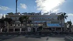
.jpg.webp)
Matrouh Governorate | |
|---|---|
 | |
.png.webp) Flag  | |
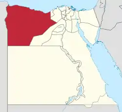 Matrouh Governorate on the map of Egypt | |
| Coordinates: 29.66°N 27.51°E | |
| Country | |
| Seat | Mersa Matruh (capital) |
| Government | |
| • Governor | Magdy Mohamed Ali El-Gharably[1] |
| Area | |
| • Total | 212,112 km2 (81,897 sq mi) |
| Population (January 2023)[2] | |
| • Total | 538,546 |
| • Density | 2.5/km2 (6.6/sq mi) |
| Time zone | UTC+2 (EET) |
| HDI (2021) | 0.738[3] high · 10th |
| Website | Matrouh |
Municipal divisions
The governorate is divided into municipal divisions with a total estimated population as of January 2023 of 538,546.[2]
| Anglicized name | Native name | Arabic transliteration | Population (January 2023 Est.) | Type |
|---|---|---|---|---|
| El Dabaa | قسم الضبعة | Aḍ-Ḍab'ah | 61,363 | Kism (urban and rural parts) |
| El Alamein | قسم العلمين | Al-'Alamayn | 12,398 | Kism (fully rural) |
| El Hamam | قسم الحمام | Al-Ḥammām | 65,780 | Kism (urban and rural parts) |
| El Negaila | قسم النجيله | An-Najīlah | 34,593 | Kism (urban and rural parts) |
| North Coast | قسم الساحل الشمالى-جزء | As-Sāḥal ash-Shamāli | 88 | Kism (fully urban) |
| Sallum | قسم السلوم | As-Sallūm | 20,479 | Kism (urban and rural parts) |
| Mersa Matruh | قسم مرسى مطروح | Marsá Maṭrūḥ | 241,625 | Kism (urban and rural parts) |
| Sidi Barrani | قسم سيدى برانى | Sīdī Barrānī | 66,319 | Kism (urban and rural parts) |
| Siwa Oasis | قسم سيوة | Sīwa | 35,901 | Kism (urban and rural parts) |
Overview
The interior of the Matrouh Governorate is part of Egypt's Western Desert, including the Siwa Oasis, in antiquity known for its shrine to Amun. In the center of the Governorate is the Qattara Depression, descending to 133 metres below sea level.
Marsa Matrouh is the ancient Koinē Greek: Παραιτόνιον Paraitónion, Latin Paraetonium. It was the westernmost city of the Ptolemaic Kingdom in the Hellenistic period. The city of Apis, some 18 km to the west of Paraetonium, marked the boundary to Libycus nome, and the Halfaya Pass (at Sallum) marked the boundary to Marmarica proper.
Matrouh Governorate contains many historical sites related to World War II. The latter include el Alamein, which comprises cemeteries of fallen soldiers from Axis and Allied forces. An estimated 16 million mines,[4] planted by the Europeans during the world wars and called "devil's gardens", still hinder development of most of the governorate, and are constantly being removed.
The province has been described as "religiously conservative".[5]
Population
According to population estimates, in 2015 the majority of residents in the governorate lived in urban areas, with an urbanization rate of 70.6%. Out of an estimated 447,846 people residing in the governorate, 316,005 people lived in urban areas as opposed to only 131,841 in rural areas.[6]
Industrial zone
According to the Egyptian Governing Authority for Investment and Free Zones (GAFI), in affiliation with the Ministry of Investment (MOI), the following industrial zones are located in this governorate:[7]
- The industrial zone in K 26
References
- رسمياً.. المحافظون الجدد ونوابهم يؤدون اليمين الدستورية أمام الرئيس. Almasry Alyoum (in Arabic). 30 August 2018. Archived from the original on 2018-08-31. Retrieved 2018-08-31.
- (PDF) https://www.capmas.gov.eg/Admin/Pages%20Files/202331512347%D8%B9%D8%AF%D8%AF%20%D8%A7%D9%84%D8%B3%D9%83%D8%A7%D9%86%20%D8%B9%D9%84%D9%89%20%D9%85%D8%B3%D8%AA%D9%88%D9%89%20%D8%A7%D9%84%D9%85%D8%B1%D8%A7%D9%83%D8%B2%20%D9%88%D8%A7%D9%84%D8%A7%D9%82%D8%B3%D8%A7%D9%85%20%D9%81%D9%89%201%D9%80%201%D9%80%202023.pdf. Retrieved 3 April 2023.
{{cite web}}: Missing or empty|title=(help) - "Sub-national HDI - Subnational HDI - Table - Global Data Lab". globaldatalab.org. Retrieved 2023-02-20.
- خارج القاهرة: ربع مليون فدان آلغام بمطروح Archived 2016-03-30 at the Wayback Machine - ONTV - 13 Jan 2012 (in Arabic)
- "Deepening rifts". The Economist. 25 Jan 2014. Archived from the original on 2018-07-13. Retrieved 2018-07-13.
- "Population Estimates By Sex & Governorate 1/1/2015" (PDF). CAPMAS. Archived from the original (PDF) on 2015-10-19. Retrieved 23 October 2016.
- "Industrial Zones of Governorate". Ministry of Investment Egypt. Archived from the original on 2018-11-23. Retrieved 23 November 2018.
External links
| Urban | ||
|---|---|---|
| Lower Egypt | ||
| Upper Egypt | ||
| Frontier | ||