Matsumae, Hokkaido
Matsumae (松前町, Matsumae-chō) is a town located in Oshima Subprefecture, Hokkaido, Japan. The former home of the Matsumae Han, it has an Edo period castle, Matsumae Castle, the only one in Hokkaido, and Ryūun-in.
Matsumae
松前町 | |
|---|---|
Town | |
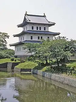 Matsumae Castle (July 2004) | |
 Flag  Emblem | |
 Location of Matsumae in Oshima Subprefecture, Hokkaido | |
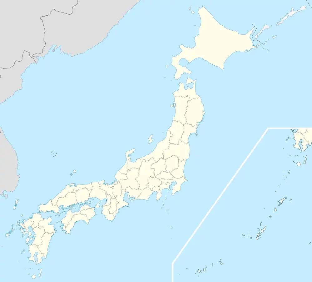 Matsumae Location in Japan | |
| Coordinates: 41°26′N 140°7′E | |
| Country | Japan |
| Prefecture | Hokkaido |
| District | Matsumae |
| Government | |
| • Mayor | Hideo Ishiyama (石山 英雄) |
| Area | |
| • Total | 293.11 km2 (113.17 sq mi) |
| Population (2016) | |
| • Total | 7,843 |
| • Density | 27/km2 (69/sq mi) |
| Time zone | UTC+09:00 (JST) |
| Postal code(s) | 049-1592 |
| Area code | 0139 |
| City hall address | Aza Fukiyama 248, Matsumae-chō, Matsumae-gun, Hokkaidō 049-1592 |
| Climate | Cfa |
| Website | www |
| Symbols | |
| Flower | Cherry blossom |
| Tree | Pine |
The total area of the town is 293.11 square kilometres (113.17 sq mi).
History
- 1900: Fukuyama town was founded.
- 1940: Fukuyama changed its name to Matsumae.
- 1953: Matsumae Line opened.
- 1954: Matsumae town, Oshima village, Osawa village, and Kojima village were merged to form Matsumae town.
- 1988: Matsumae Line was abolished.[1]
Geography
The town is located on the southern end of the Matsumae Peninsula. In addition the town governs the two islands in the Tsugaru Strait, Oshima and Kojima.[2]
Along with Kaminokuni, Hokkaido, and Fukushima, Hokkaido, Matsumae shares a border with Mount Daisengen, and contains the newest and shortest climbing route to the summit of the mountain.[3]
Climate
| Climate data for Matsumae, Hokkaido (1991−2020 normals, extremes 1977−present) | |||||||||||||
|---|---|---|---|---|---|---|---|---|---|---|---|---|---|
| Month | Jan | Feb | Mar | Apr | May | Jun | Jul | Aug | Sep | Oct | Nov | Dec | Year |
| Record high °C (°F) | 11.1 (52.0) |
13.8 (56.8) |
15.3 (59.5) |
23.3 (73.9) |
25.7 (78.3) |
29.3 (84.7) |
33.3 (91.9) |
34.2 (93.6) |
31.5 (88.7) |
24.9 (76.8) |
20.3 (68.5) |
15.8 (60.4) |
34.2 (93.6) |
| Average high °C (°F) | 1.9 (35.4) |
2.4 (36.3) |
5.8 (42.4) |
11.0 (51.8) |
15.9 (60.6) |
20.0 (68.0) |
23.7 (74.7) |
25.9 (78.6) |
23.1 (73.6) |
17.3 (63.1) |
10.7 (51.3) |
4.5 (40.1) |
13.5 (56.3) |
| Daily mean °C (°F) | −0.5 (31.1) |
−0.1 (31.8) |
3.0 (37.4) |
7.9 (46.2) |
12.5 (54.5) |
16.6 (61.9) |
20.6 (69.1) |
22.7 (72.9) |
19.8 (67.6) |
14.1 (57.4) |
7.8 (46.0) |
1.9 (35.4) |
10.5 (50.9) |
| Average low °C (°F) | −3.0 (26.6) |
−2.7 (27.1) |
0.1 (32.2) |
4.7 (40.5) |
9.4 (48.9) |
13.5 (56.3) |
18.1 (64.6) |
20.0 (68.0) |
16.7 (62.1) |
10.9 (51.6) |
4.8 (40.6) |
−0.7 (30.7) |
7.7 (45.8) |
| Record low °C (°F) | −11.6 (11.1) |
−10.4 (13.3) |
−7.9 (17.8) |
−3.7 (25.3) |
2.2 (36.0) |
6.3 (43.3) |
10.6 (51.1) |
12.6 (54.7) |
7.6 (45.7) |
2.7 (36.9) |
−6.1 (21.0) |
−11.4 (11.5) |
−11.6 (11.1) |
| Average precipitation mm (inches) | 87.1 (3.43) |
72.9 (2.87) |
63.9 (2.52) |
73.5 (2.89) |
97.5 (3.84) |
80.0 (3.15) |
124.9 (4.92) |
157.5 (6.20) |
155.2 (6.11) |
115.5 (4.55) |
122.0 (4.80) |
106.0 (4.17) |
1,251.3 (49.26) |
| Average rainy days | 18.4 | 15.5 | 13.3 | 10.3 | 10.2 | 8.7 | 10.4 | 9.8 | 11.5 | 12.4 | 15.7 | 18.9 | 155.1 |
| Mean monthly sunshine hours | 46.9 | 66.7 | 132.3 | 175.7 | 173.4 | 159.2 | 137.4 | 170.3 | 171.1 | 153.3 | 82.1 | 50.1 | 1,518.5 |
| Source 1: JMA[4] | |||||||||||||
| Source 2: JMA[5][6] | |||||||||||||
Demographics
As of September 2016, the town has an estimated population of 7,843 and a density of 26.7 persons per km2.
Culture and lifestyle
Surrounding Matsumae Castle is Matsumae Park, which features over 10,000 cherry trees of over 250 varieties, and is ranked among the top cherry blossom viewing spots in the country.[7]
Education
High school
- Hokkaido Matsumae High School (the southernmost high school in Hokkaido)[8]
Sister cities
- Omihachiman, Shiga (since 1984) [9]
- Masaki, Ehime (since 1990) [10]
- Date, Fukushima (since 2011) [11]
References
- Matsumae Line Archived 2015-02-27 at the Wayback Machine
- "gotyuuikudasai" (in Japanese). 松前町役場. Archived from the original on 15 July 2010. Retrieved 30 June 2010.
- "大千軒岳情報 | 渡島総合振興局森林室西部森林室". www.oshima.pref.hokkaido.lg.jp. Retrieved 2020-07-14.
- 観測史上1~10位の値(年間を通じての値). JMA. Retrieved February 20, 2022.
- 気象庁 / 平年値(年・月ごとの値). JMA. Retrieved February 20, 2022.
- https://twitter.com/extremetemps/status/1618277904043102208
- "Matsumae". www.japan-guide.com. Retrieved 2020-07-14.
- Hokkaido Matsumae High School
- Sister cities of Omihachiman
- Interaction with sister city, Matsumae
- Sister cities of Date
External links
![]() Media related to Matsumae, Hokkaidō at Wikimedia Commons
Media related to Matsumae, Hokkaidō at Wikimedia Commons
- Official Website (in Japanese)
| ||||||||||||
| ||||||||||||
| ||||||||||||
| ||||||||||||
| ||||||||||||
| ||||||||||||
| ||||||||||||
| ||||||||||||
| ||||||||||||
| ||||||||||||
| ||||||||||||
| ||||||||||||
| ||||||||||||
| ||||||||||||