Mau Ping
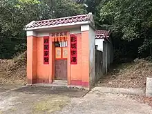
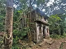
Mau Ping (Chinese: 茅坪; lit. 'Grass Field')[1] is an area and the site of a former village in Hong Kong. It is located within Ma On Shan Country Park and is administratively part of Sha Tin District.

Administration
Mau Ping is a recognized village under the New Territories Small House Policy.[2]
History
The village of Mau Ping, together with neighboring Mui Tsz Lam, were historically part of the Luk Yeuk (league), centered on the township of Sai Kung.[3] At the time of the 1911 census, the population of Mau Ping (Mu Ping) was 124. The number of males was 57.[4]
Conservation
A dense woodland with an area of 3.7 hectares, within the Mau Ping area, has been listed as a Site of Special Scientific Interest since 1979.[5][6]
Access
Mau Ping is only accessible by hiking paths, including Mau Ping Ancient Trail (茅坪古道) from Mui Tsz Lam, Pak Kong Ancient Trail (北港古道) from Pak Kong, Wong Chuk Shan Ancient Trail (黃竹山古道) from Buffalo Pass via Wong Chuk Shan, and Section 4 of the MacLehose Trail.
See also
References
- Aijmer, Göran (1968). "Being Caught by a Fishnet: On Fengshui in Southeastern China" (PDF). Journal of the Royal Asiatic Society Hong Kong Branch. 8: 74–81. ISSN 1991-7295.
- "List of Recognized Villages under the New Territories Small House Policy" (PDF). Lands Department. September 2009.
- Aijmer, Göran (1990). "European Notions of Leadership and Chinese Ethnography". In Goodman, David S. G. (ed.). China and the West: Ideas and Activists. Manchester University Press. p. 34. ISBN 978-0719029417.
- Hase, Patrick (1996). "Traditional Life in the New Territories: The Evidence of the 1911 and 1921 Censuses" (PDF). Journal of the Royal Asiatic Society Hong Kong Branch. 36: 78. ISSN 1991-7295.
- "Register of Sites of Special Scientific Interest (SSSIs)". Planning Department.
- "Site of Special Scientific Interest - Mau Ping" (PDF). Planning Department. 30 September 1992.
Further reading
- Aijmer, Göran (1967). "Expansion and Extension in Hakka Society" (PDF). Journal of the Royal Asiatic Society Hong Kong Branch. 7: 42–79. ISSN 1991-7295.