Dawson, Ontario
Dawson is a township located in Rainy River District in Northwestern Ontario, Canada. The township is located at the mouth of the Rainy River where it flows into Lake of the Woods.
Dawson | |
|---|---|
| Township of Dawson | |
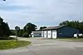
 Township office of Dawson in Rainy River | |
 Dawson | |
| Coordinates: 48°45′N 94°29′W | |
| Country | Canada |
| Province | Ontario |
| District | Rainy River |
| Formed | 1 January 1997 |
| Government | |
| • Mayor | Douglas Hartnell |
| • Federal riding | Thunder Bay—Rainy River |
| • Prov. riding | Kenora—Rainy River |
| Area | |
| • Land | 339.5 km2 (131.1 sq mi) |
| Elevation | 335 m (1,099 ft) |
| Population (2016)[1] | |
| • Total | 468 |
| • Density | 1.4/km2 (4/sq mi) |
| Time zone | UTC-6 (CST) |
| • Summer (DST) | UTC-5 (CDT) |
| Postal Code FSA | P0W 1L0 |
| Area code | 807 |
The township was formed on 1 January 1997, when the former incorporated townships of Atwood, Blue, Dilke, and Worthington were amalgamated.
Communities
The primary communities in the township are Blue, McGinnis Creek, Pinewood and Sleeman.
 Pinewood
Demographics
In the 2021 Census of Population conducted by Statistics Canada, Dawson had a population of 399 living in 190 of its 274 total private dwellings, a change of -14.7% from its 2016 population of 468. With a land area of 343.42 km2 (132.60 sq mi), it had a population density of 1.2/km2 (3.0/sq mi) in 2021.[3]
Canada census – Dawson community profile
| 2021 | 2016 | 2011 | |
|---|---|---|---|
| Population | 399 (-14.7% from 2016) | 468 (-16.9% from 2011) | 563 (-9.2% from 2006) |
| Land area | 343.42 km2 (132.60 sq mi) | 339.5 km2 (131.1 sq mi) | 338.35 km2 (130.64 sq mi) |
| Population density | 1.2/km2 (3.1/sq mi) | 1.4/km2 (3.6/sq mi) | 1.7/km2 (4.4/sq mi) |
| Median age | 56.4 (M: 57.6, F: 53.6) | 54.5 (M: 54.9, F: 53.5) | 47.8 (M: 49.1, F: 46.2) |
| Private dwellings | 274 (total) 190 (occupied) | 292 (total) | 307 (total) |
| Median household income | $75,000 | $61,312 |
| Year | Pop. | ±% |
|---|---|---|
| 1996 | 631 | — |
| 2001 | 613 | −2.9% |
| 2006 | 620 | +1.1% |
| 2011 | 563 | −9.2% |
| 2016 | 468 | −16.9% |
| [9][1] | ||
Climate
| Climate data for Sleeman | |||||||||||||
|---|---|---|---|---|---|---|---|---|---|---|---|---|---|
| Month | Jan | Feb | Mar | Apr | May | Jun | Jul | Aug | Sep | Oct | Nov | Dec | Year |
| Record high °C (°F) | 7 (45) |
11 (52) |
16.5 (61.7) |
31.5 (88.7) |
32.5 (90.5) |
33.5 (92.3) |
35 (95) |
34.5 (94.1) |
34.4 (93.9) |
26.7 (80.1) |
22.2 (72.0) |
9 (48) |
35 (95) |
| Average high °C (°F) | −11.4 (11.5) |
−7 (19) |
0.3 (32.5) |
10.5 (50.9) |
18.8 (65.8) |
22.3 (72.1) |
25 (77) |
23.4 (74.1) |
17.3 (63.1) |
10.5 (50.9) |
−0.2 (31.6) |
−8.9 (16.0) |
8.4 (47.1) |
| Daily mean °C (°F) | −17.2 (1.0) |
−13.2 (8.2) |
−5.6 (21.9) |
4.1 (39.4) |
11.8 (53.2) |
16.2 (61.2) |
19 (66) |
17.4 (63.3) |
11.8 (53.2) |
5.7 (42.3) |
−4.1 (24.6) |
−14 (7) |
2.7 (36.9) |
| Average low °C (°F) | −22.9 (−9.2) |
−19.3 (−2.7) |
−11.4 (11.5) |
−2.2 (28.0) |
4.8 (40.6) |
9.9 (49.8) |
12.9 (55.2) |
11.4 (52.5) |
6.3 (43.3) |
0.8 (33.4) |
−8 (18) |
−19.1 (−2.4) |
−3.1 (26.4) |
| Record low °C (°F) | −44 (−47) |
−41 (−42) |
−37.5 (−35.5) |
−27.8 (−18.0) |
−8 (18) |
−2 (28) |
1.1 (34.0) |
−1.7 (28.9) |
−6 (21) |
−17 (1) |
−39 (−38) |
−43 (−45) |
−44 (−47) |
| Average precipitation mm (inches) | 27.9 (1.10) |
21.6 (0.85) |
30.1 (1.19) |
37.9 (1.49) |
60.4 (2.38) |
107.5 (4.23) |
86.4 (3.40) |
90.5 (3.56) |
69.3 (2.73) |
57.7 (2.27) |
37.2 (1.46) |
23.5 (0.93) |
650 (25.6) |
| Source: Environment Canada[2] | |||||||||||||
See also
References
- "Census Profile, 2016 Census: Dawson, Township". Statistics Canada. 8 February 2017. Retrieved 2 July 2019.
- Environment Canada – Canadian Climate Normals 1971–2000, accessed 2011-05-05
- "Population and dwelling counts: Canada, provinces and territories, census divisions and census subdivisions (municipalities), Ontario". Statistics Canada. 9 February 2022. Retrieved 2 April 2022.
- "2021 Community Profiles". 2021 Canadian Census. Statistics Canada. 4 February 2022. Retrieved 19 October 2023.
- "2016 Community Profiles". 2016 Canadian Census. Statistics Canada. 12 August 2021. Retrieved 2 July 2019.
- "2011 Community Profiles". 2011 Canadian Census. Statistics Canada. 21 March 2019. Retrieved 30 March 2012.
- "2006 Community Profiles". 2006 Canadian Census. Statistics Canada. 20 August 2019.
- "2001 Community Profiles". 2001 Canadian Census. Statistics Canada. 18 July 2021.
- Statistics Canada: 2001, 2006, 2011 census
Places adjacent to Dawson, Ontario | |
|---|---|
| Towns |  | |
|---|---|---|
| Townships | ||
| First Nations | ||
| Indian reserves |
| |
| Unorganized areas | ||
| Unincorporated communities | ||
| ||
This article is issued from Wikipedia. The text is licensed under Creative Commons - Attribution - Sharealike. Additional terms may apply for the media files.