Meadowbank, New Zealand
Meadowbank is a suburb of Auckland city, situated in the North Island of New Zealand. Meadowbank is governed under the local governance of the Auckland Council. It has one shopping centre: Meadowbank Shopping Centre, on the corner of Gerard Way and St John's Road. Purewa Cemetery, one of central Auckland's largest cemeteries, is situated in Meadowbank and can be accessed from St John's Road.
Meadowbank | |
|---|---|
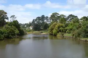 Ōrākei Creek in Meadowbank, as seen from the Waiatarua Road overbridge | |
| Coordinates: 36.871924°S 174.826907°E | |
| Country | New Zealand |
| City | Auckland |
| Local authority | Auckland Council |
| Electoral ward | Ōrākei ward |
| Local board | Ōrākei Local Board |
| Area | |
| • Land | 169 ha (418 acres) |
| Population (June 2023)[2] | |
| • Total | 5,500 |
| Postcode(s) | 1072 |
| Train station(s) | Meadowbank Railway Station |
| Parnell (3.9 km) | Ōrākei (1.6 km) | Mission Bay (2.0 km) |
| Remuera (2.2 km) |
|
Glen Innes (3.6 km) |
| Greenlane (3.6 km) | Ellerslie (3.2 km) | St Johns (1.9 km) |
History
In 1930, an extension of the Remuera electric tramway was opened, servicing Meadowbank.[3]
Demographics
Meadowbank covers 1.69 km2 (0.65 sq mi)[1] and had an estimated population of 5,500 as of June 2023,[2] with a population density of 3,254 people per km2.
| Year | Pop. | ±% p.a. |
|---|---|---|
| 2006 | 4,695 | — |
| 2013 | 5,049 | +1.04% |
| 2018 | 5,328 | +1.08% |
| Source: [4] | ||
Meadowbank had a population of 5,328 at the 2018 New Zealand census, an increase of 279 people (5.5%) since the 2013 census, and an increase of 633 people (13.5%) since the 2006 census. There were 1,947 households, comprising 2,499 males and 2,829 females, giving a sex ratio of 0.88 males per female, with 1,188 people (22.3%) aged under 15 years, 840 (15.8%) aged 15 to 29, 2,619 (49.2%) aged 30 to 64, and 684 (12.8%) aged 65 or older.
Ethnicities were 76.5% European/Pākehā, 6.2% Māori, 4.8% Pacific peoples, 16.8% Asian, and 4.1% other ethnicities. People may identify with more than one ethnicity.
The percentage of people born overseas was 33.8, compared with 27.1% nationally.
Although some people chose not to answer the census's question about religious affiliation, 44.3% had no religion, 43.2% were Christian, 0.3% had Māori religious beliefs, 1.5% were Hindu, 1.3% were Muslim, 1.6% were Buddhist and 2.7% had other religions.
Of those at least 15 years old, 1,914 (46.2%) people had a bachelor's or higher degree, and 291 (7.0%) people had no formal qualifications. 1,449 people (35.0%) earned over $70,000 compared to 17.2% nationally. The employment status of those at least 15 was that 2,325 (56.2%) people were employed full-time, 600 (14.5%) were part-time, and 138 (3.3%) were unemployed.[4]
| Name | Area (km2) | Population | Density (per km2) | Households | Median age | Median income |
|---|---|---|---|---|---|---|
| Meadowbank West | 1.04 | 2,730 | 2,625 | 948 | 37.9 years | $47,400[5] |
| Meadowbank East | 0.65 | 2,598 | 3,997 | 999 | 37.8 years | $50,800[6] |
| New Zealand | 37.4 years | $31,800 |
Education
St John's College and Trinity Theological College are also located on St John's Road. Local primary schools include Meadowbank School (public) and Mt Carmel School, Meadowbank (state-integrated Catholic). Local secondary schools comprise Selwyn College and Baradene College of the Sacred Heart. Mount Carmel School is a coeducational state-integrated Catholic primary school (years 1–6) with a roll of 224 as of April 2023.[7][8]
References
- "ArcGIS Web Application". statsnz.maps.arcgis.com. Retrieved 18 July 2022.
- "Population estimate tables - NZ.Stat". Statistics New Zealand. Retrieved 25 October 2023.
- "TRAM EXTENSION AT REMUERA OPENED". Auckland Sun. Papers Past. 9 June 1930. p. 16. Retrieved 31 August 2021.
- "Statistical area 1 dataset for 2018 Census". Statistics New Zealand. March 2020. Meadowbank West (141900) and Meadowbank East (143200).
- 2018 Census place summary: Meadowbank West
- 2018 Census place summary: Meadowbank East
- "New Zealand Schools Directory". New Zealand Ministry of Education. Retrieved 12 December 2022.
- Education Counts: Mount Carmel School
External links
- Photographs of Meadowbank held in Auckland Libraries' heritage collections.