Megalithic Walls of Altamura
The Megalithic Walls of Altamura (Italian: Mura megalitiche di Altamura) are defensive walls dating back to the 4th century BCE. They were the city walls of the ancient city of Altamura, Italy. Nowadays, only a few parts of the original wall remain; the original track of the wall spanned over a length of about 3.6 km. They were about 4 meters high, while the base of the walls was about 5 meters wide.[1]
| Megalithic Walls of Altamura | |
|---|---|
| Native name Italian: Mura megalitiche di Altamura | |
 View from via Cassano (Altamura, Italy) | |
| Nearest city | Altamura |
| Coordinates | 40.831116°N 16.563098°E |
| Height | about 5 meters |
| Original use | Defensive wall of the ancient city (before the Middle Ages) |
The megalithic walls are often confused with the city walls of today's Altamura historic center, of which fragments remain today in some parts as well. The two walls refer to different time periods and to different parts of the city: the megalithic walls refer to the ancient city, which was later abandoned or sacked, while the walls of Altamura historic center refer to the period starting from the founding of Altamura by king Frederick II of Hohenstaufen (13th century AD).
Cesare Orlandi
Cesare Orlandi, in his work Delle città d'Italia (1770), mentioned the wall and suggested that the name of the city of Altamura might be due to its megalithic walls. He also mentioned a large number of archaeological findings of that period, which occurred very close the megalithic walls and that now have been lost.
According to the common opinion, Altamura was said to be placed on top of highest part of an ancient wall, which still exists, and it is believed to be older than the time the city was refounded by the emperor Frederick II. This ancient wall, made of large square stones, is about three miles long; starting from the top and spreading along the base of the hill, facing towards the North. Up to the present time, such a wall preserves the ancient remains of three of its gates, and it embraces some small roads, and landed wells. Along the foot outside this wall, and in its vicinity, ancient sepulchres, with human bones, of both precious and low-metal medals, Greek and Roman, are found from time to time under the ground; household tools, perpetual lamps, with asbestos wicks: basins, lacrimal urns [..]. From similar findings, it is inferred that such an old wall belonged to a sacked city.
Rocca maps
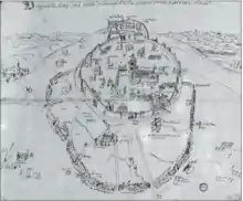
Inside Rocca map P/33, commissioned by Angelo Rocca and stored inside Angelica Library, Rome, some memorial stones can be seen on the megalithic walls. At the end of the 16th century, those memorial stones were still present, before being destroyed at a certain point.[2]
Gallery
 Megalithic walls of Altamura - Via Cassano
.jpg.webp) Megalithic walls of Altamura - Part between via Cassano and via Santeramo
Megalithic walls of Altamura - Part between via Cassano and via Santeramo.jpg.webp) The only gate (called "Porta Alba") that survived of the megalithic walls - Part between via Cassano and via Bari
The only gate (called "Porta Alba") that survived of the megalithic walls - Part between via Cassano and via Bari Megalithic walls of Altamura in 1584 (external walls) and the defensive wall of the new city of Altamura (Archivio Generalizio Agostiniano - Carte Rocca P33, stored in Biblioteca Angelica, Rome)
References
- "Le Mura Megalitiche di Altamura". rilievo.stereofot.it.
- pupillo-immagini, pp. 18, 20
Bibliography
- Orlandi, Cesare (1770). Delle città d'Italia e sue isole adjacenti [sic] compendiose notizie - Tomo primo.
- Pupillo, Giuseppe; Operatori C.R.S.E.C. BA/7 (2017). Altamura, immagini e descrizioni storiche (PDF). Matera: Antezza Tipografi. ISBN 9788889313282. Archived from the original (PDF) on 2018-10-21. Retrieved 2020-01-21.
- Berloco, Tommaso (1985). Storie inedite della città di Altamura. ATA - Associazione Turistica Altamurana Pro Loco.