Mékinac Regional County Municipality
Mékinac (French: [mekinak]) is a regional county municipality (RCM) in the administrative region of Mauricie, in the province of Quebec, Canada. Its seat is Saint-Tite. It is composed of 10 municipalities and 4 unorganized territories.
Mékinac (RCM) | |
|---|---|
 | |
| Coordinates: 46°49′N 72°31′W | |
| Country | |
| Province | |
| Region | Mauricie |
| Effective | January 1, 1982 |
| County seat | Saint-Tite |
| Municipalities | |
| Government | |
| • Type | Prefecture |
| • Prefect | Alain Vallée |
| Area | |
| • Total | 5,554.90 km2 (2,144.76 sq mi) |
| • Land | 5,222.10 km2 (2,016.26 sq mi) |
| Population (2016)[2] | |
| • Total | 12,358 |
| • Density | 2.4/km2 (6/sq mi) |
| • Change 2011-2016 | |
| • Dwellings | 8,324 |
| Time zone | UTC−5 (EST) |
| • Summer (DST) | UTC−4 (EDT) |
| Area code(s) | 418 and 581 |
| Website | Official web site |

Toponymy
Mékinak, (Algonquin). — Lake, river and township of Champlain County. The Mékinac River flows into the Saint-Maurice twelve miles upstream of Les Piles, and 57 miles from Trois-Rivières.
A few spell it Mékinac, but the geographic office of Canada considers the ending in k. This word means turtle, and according to Father N. Caron, it was given because of a mountain that had more or less the shape of a turtle.
In the Cree idiom, this word also has the same meaning. In his lexicon of the Algonquin language, Father Cuoq translates Micinimakina as "big turtle" and brings this word of mici which would have lengthened in micini, and mikinak.
—Translate from french, source: Publications de la Société du Parler français au Canada 1906[3]
The Algonquin Mikinak means turtle. Native Americans often referred to places based on the naming of the animal kingdom. Once well known, the toponym made it possible to refer to the same place in conversations. The designation Mikinak would have been assigned to a nearby mountain. However, it remains possible that the abundance of turtles in this portion of the territory explains this name[4]
However, the name is also similar to the historical Algonquin word mekanâc, pronounced /me:kana:ʃ/, meaning "small path". The toponym Mekinac was assigned to the Mékinac River, Mékinac Lake, at Mékinac (township), in the ex-municipality of Saint-Joseph-de-Mékinac, Quebec, and town of Saint-Roch-de-Mékinac.
Hydrography
Three great rivers
The Saint-Maurice River - the Batiscan River - the Sainte-Anne River flow from west to east, on the territory of the Mékinac RCM.
The MRC hydrographic network includes
- 2,964 km of permanent watercourses
- 2,863 km of intermittent waterways for a total of 5827 km.
- Nearly 38% (2,241 km) of this system flows on private land where there are 791 km (35%) of permanent watercourses and 1,450 km intermittent (65%)
Source: MRC de Mékinac, Plan régional des milieux humides et hydriques
Four thousand, six hundred sixty-five lakes
The Mékinac RCM has 4,665 lakes for a total area of 34,272.8 ha (342.7 km2).
- The number of lakes of one hectare or more is 1,869.
- Lakes of less than one hectare correspond to nearly 60% (2,797 ha) of all water bodies in the MRC.
- The largest is Lake Mékinac measuring 2,297 ha (23.0 km2). It is divided between the Mékinac RCM and the La Tuque agglomeration, where most (79.9%) is in the Mékinac RCM.
- Most lakes (53.4%) in the MRC are classified as very small (1 to 5 ha) according to Bazoge and Blais (2005) with an area of less than 5 ha.
- Conversely, there are only three very large lakes (625 ha and more) in the MRC, lakes Mékinac, Normand and Salone.
Source: MRC de Mékinac, Plan régional des milieux humides et hydriques[5]
Subdivisions
There are 14 subdivisions within the RCM:
|
|
|
|
|
Municipalities of MRC Mékinac
| Municipality | Status | Surface km2 |
Population (2011)[6] | Density hab./km2 |
|---|---|---|---|---|
| Grandes-Piles | Village municipality | 120.53 | 361 | 3.0 |
| Hérouxville | Parish municipality | 53.04 | 1,340 | 25.3 |
| Lac-aux-Sables | Parish municipality | 270.38 | 1,373 | 5.1 |
| Lac-Boulé | Unorganized area | 22.96 | 0 | 0.0 |
| Lac-Masketsi | Unorganized area | 213.29 | 0 | 0.0 |
| Lac-Normand | Unorganized area | 2,038.09 | 5 | 0.0 |
| Notre-Dame-de-Montauban | Municipality | 165.37 | 747 | 4.5 |
| Rivière-de-la-Savane | Unorganized area | 1,088.02 | 0 | 0.0 |
| Saint-Adelphe | Parish municipality | 137.45 | 952 | 6.9 |
| Saint-Roch-de-Mékinac | Parish municipalityh | 144.59 | 438 | 3.0 |
| Saint-Séverin | Parish municipality | 62.28 | 860 | 13.8 |
| Saint-Tite | City | 92.53 | 3,880 | 41.9 |
| Sainte-Thècle | Municipality | 213.46 | 2,478 | 11.6 |
| Trois-Rives | Municipality | 603.94 | 490 | 0.8 |
| Total | 5,226.08 | 12,919 | 2.47 | |
Between 2006 and 2011, the population grew by 2.0%. The MRC has 8,237 private dwellings whose 6,096 private dwellings are occupied by usual residents. The median age of the population is 52.6 years old. Statistics Canada reports that in 2011, 88.5% of the population was aged 15 and over, meanings 11,430 individuals (including 5700 men and 5730 women), divided into 3,940 private households. This census indicates that 2,070 people lived alone. Of this population, 1,880 individuals have mastered both French and English, or 14.6%.[7]
Transportation
See also
- List of regional county municipalities and equivalent territories in Quebec
- Batiscanie, Quebec
- Batiscan River
- Rivière des Envies
- North Mékinac River
- South Mékinac River
- Rivière du milieu (Mékinac)
- Rivière aux eaux mortes (Mékinac)
- Tawachiche River
- Tawachiche West River
- Pierre-Paul River
- Saint-Maurice River
- Mékinac River
- Mékinac Lake
- Missionary Lake
- Lake Jesuit
- Lake Traverse (Mékinac)
- Regional County Municipality
- Irénée-Marie Ecological Reserve
- Grande-Anse (Mékinac) (hamlet)
Photos
The Mauricie's major rivers Saint-Maurice, Batiscan, Sainte-Anne (Les Chenaux) and their tributaries cross the territory of Mékinac RCM
- Tributaries of major rivers in Hérouxville
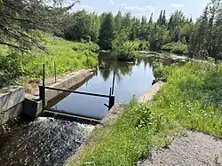 Dam, Rivière à la Tortue
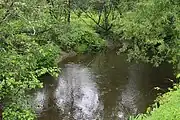 Rivière à la Tortue
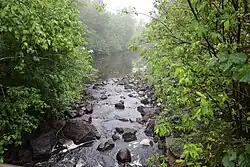 South Mékinac River
References
- Ministère des Affaires municipale et des Régions du Québec. "Mékinac - Résertoire des municipalités". Archived from the original on 2013-12-20. Retrieved 2008-01-11.
- "Census Profile, 2016 Census Mékinac, Municipalité régionale de comté [Census division], Quebec". Statistics Canada. Retrieved December 8, 2019.
- Rouillard, Eugene. "Noms géographiques de la province de Québec et des provinces maritimes empruntés aux langues sauvages". Bibliothèque et Archives nationales du Québec. Publications de la Société du Parler français au Canada 1906. p. 61. Retrieved 19 June 2023.
- "Saint-Roch-de-Mékinac, origin and signification". Commission de toponymie Quebec (in French). Quebec Gouvernement. Retrieved 20 June 2023.
- "MRC de Mékinac Plan régional des milieux humides et hydriques Portrait environnemental" (PDF) (in French). Société d'aménagement et de mise en valeur du bassin de la Batiscan (SAMBBA). 29 September 2021. Retrieved 20 June 2023.
- Recensement de 2011 du Canada
- "Mékinac Regional County Municipality (Code 2435) Census Profile". 2011 census. Government of Canada - Statistics Canada.
- Official Transport Quebec Road Map
Adjacent Counties & Equivalent Territories | |
|---|---|
| Regional county municipalities and equivalent territories | |
|---|---|
| Municipalities | |