Mercy Bay
Mercy Bay is a Canadian Arctic waterway in the Northwest Territories. It is a southern arm of M'Clure Strait on northeast Banks Island. The mouth of Castel Bay is less than 20 kilometres (12 mi) to the west. These bays are a part of Aulavik National Park.
HMS Investigator

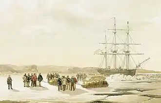
In September 1851, Captain Robert McClure's ship, HMS Investigator became ice trapped in Mercy Bay during his search for the Northwest Passage and the lost Sir John Franklin Expedition. By 1853, it was finally abandoned in the bay. The crew sledged over ice to Melville Island, where they were rescued.[1]
.jpg.webp)
In July 2010, Parks Canada archeologists looking for HMS Investigator found it fifteen minutes after they started a sonar scan of Banks Island, Mercy Bay, Northwest Territories. The archaeology crew had no plans to raise the ship. They did a thorough sonar scan of the area, then sent an ROV (a remotely operated vehicle).[2] The Canadian archaeologists found the ship "largely intact", sitting upright in approximately 25 feet of pristine Arctic water. Its masts were missing, probably sheared away by the ice.[3]
References
- "European exploration". Parks Canada. Retrieved 2008-11-02.
- "Abandoned 1854 ship found in Arctic". CBC News. July 29, 2010. Retrieved 29 July 2010.
- "BBC News - Canadian team finds 19th Century HMS Investigator wreck". Bbc.co.uk. 2010-07-28. Retrieved 2010-07-29.