Calderdale
Calderdale is a metropolitan borough of West Yorkshire, England, which had a population of 211,439.[2] It takes its name from the River Calder, and dale, a word for valley. The name Calderdale usually refers to the borough through which the upper river flows, while the actual landform is known as the Calder Valley. Several small valleys contain tributaries of the River Calder. The main towns of the borough are Brighouse, Elland, Halifax, Hebden Bridge, Sowerby Bridge and Todmorden.
Borough of Calderdale | |
|---|---|
.jpg.webp) View over Mytholmroyd in the Upper Calder Valley | |
| Motto(s): Industria Arte Prudentia (Latin: Industry, skill and foresight) | |
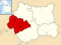 Calderdale shown within West Yorkshire | |
| Sovereign state | |
| Constituent country | |
| Region | Yorkshire and the Humber |
| Metropolitan county | West Yorkshire |
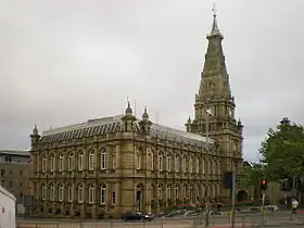
| Admin. HQ | Halifax |
| Established | 1 April 1974 |
| Government | |
| • Type | Metropolitan Borough |
| • Body | Calderdale Council |
| • Leadership | Leader & Cabinet |
| • MPs | Craig Whittaker (C) (Calder Valley),
Holly Lynch (L) (Halifax) |
| Area | |
| • Total | 363.9 km2 (140.5 sq mi) |
| Population (2020 estimate) | |
| • Total | 211,439 (Ranked 95th) |
| • Density | 581/km2 (1,500/sq mi) |
| • Ethnicity |
|
| Time zone | UTC+0 (Greenwich Mean Time) |
| • Summer (DST) | UTC+1 (British Summer Time) |
| Postcode areas | HD2–HD6, HX1–HX7, OL14, WF14, BD13–BD19 |
| Dialling Codes | 01422 (central core) 01484 (Brighouse/Rastrick) 01706 (Todmorden area) 01274 (Shelf area) |
| ONS code | 00CY (ONS) E08000033 (GSS) |
| Website | www.calderdale.gov.uk |
Calderdale covers part of the South Pennines, and the Calder Valley is the southernmost of the Yorkshire Dales, though it is not part of the Yorkshire Dales National Park. The borough was formed in 1974 by the merger of nine local government districts.
Halifax is the commercial, cultural and administrative centre of the borough. Calderdale is served by Calderdale Council, which is headquartered in Halifax, with some functions based in Todmorden.
History
The Roman settlement of Cambodunum was probably located within Calderdale. A Roman fort has been excavated in Slack, which is in the neighbouring borough of Kirklees, but its identity is not yet certain.
The metropolitan district of Calderdale was created on 1 April 1974 under the Local Government Act 1972. It covered the area of eight former districts and part of a ninth, which were all abolished at the same time:[3][4][5]
- Municipal Borough of Brighouse
- Elland Urban District
- County Borough of Halifax
- Hebden Royd Urban District
- Hepton Rural District
- Queensbury and Shelf Urban District (Shelf part only, Queensbury went to Bradford)
- Ripponden Urban District
- Sowerby Bridge Urban District
- Municipal Borough of Todmorden
In 2022, Yorkshire Water built an emergency water pipeline from Calderdale to Ponden Reservoir in Haworth as Yorkshire experienced its driest period on record.[6]
Governance
The borough is divided into 17 wards and each is represented on Calderdale Metropolitan Borough Council by three councillors. Each councillor is normally elected on a first past the post basis for a four-year period which is staggered with the other councillors of that ward so that only one councillor per ward is up for election at any one time. Exceptions to this include by-elections and ward boundary changes.
Demography
The largest ethnic group within Calderdale at the 2011 census was White British at 86.7%, down from 90.8% in 2001.[7] The next largest ethnic group are Pakistanis, comprising 6.8% of the population (4.9% in 2001).[7]
In 2011, Christians comprised 60.6% of the borough's population. This was followed by those of no religion (30.2%) and Muslims (7.8%).[8]
In 2019, those who were not born in the UK formed 8% of Calderdale's population.[9]
Public services, transport and facilities
Health
Calderdale is part of the Calderdale Primary Care Trust, South West Yorkshire NHS Foundation Trust and Calderdale & Huddersfield NHS Foundation Trust. The borough has two hospitals and one hospice. The main hospital (part of Calderdale & Huddersfield NHS Foundation Trust) is the Calderdale Royal Hospital, located on the main route to Huddersfield in Salterhebble. It has specialist departments: Calderdale's A&E department and the Calderdale Birth Centre.[10] The hospital was built and opened in 2001 on the site of the original Halifax General Hospital. After the new hospital opened, the Royal Halifax Infirmary closed and all services were transferred, as were services from Northowram Hospital. NHS Ambulance services are provided by the Yorkshire Ambulance Service from stations in Halifax, Brighouse and Todmorden. Overgate Hospice provides specialist palliative care for adults in Calderdale. Elland Hospital, Calderdale's only private hospital, is located by the Calderdale Way. Formerly BUPA Elland Independent Hospital, it is now owned and operated by Classic Hospitals.
Police
Calderdale is served by West Yorkshire Police; whose Calderdale Division headquarters is at Halifax police station. Other police stations are located in Todmorden[11] and at Brighouse, which reopened in 2009.[12]
Fire and rescue
West Yorkshire Fire & Rescue covers Calderdale and it has five fire stations in the borough. These are located at Rastrick (Since 2015), King Cross (Halifax Fire Station), Mytholmroyd, Illingworth, and Todmorden.[13]
Libraries
Calderdale Libraries provides services through 22 local library branches, including a central library in Halifax, and also offer a home library service and digital library service.[14] In 2014, construction began on a new central library and archive building in Halifax, adjacent to the Piece Hall and the Square Chapel.[15][16][17] The new Central Library and Archive officially opened in September 2017.[18]
Transport
Calderdale has seven operative railway stations, with one more planned to open in 2025: Brighouse, Halifax, Hebden Bridge, Mythomroyd, Sowerby Bridge, Todmorden, Walsden and the currently funded Elland station in planning.
Education
Two selective schools in Calderdale jointly administer an 11+ admissions exam: The Crossley Heath School, in Savile Park and North Halifax Grammar School in Illingworth.
Both schools achieve excellent GCSE and A-level results, achieving a large proportion of A* to C grades at GCSE level. In 2005 the Crossley Heath School was the highest ranking co-educational school in the north of England.
Calderdale College is a local further education college on Francis Street, in Halifax. In December 2006 it was announced that Calderdale College, in partnership with Leeds Metropolitan University, would open a new higher education institution in January 2007 called University Centre Calderdale.[19]
Sport
There are three current swimming pools in Calderdale. These are located in Todmorden, Brighouse and Sowerby Bridge. Halifax is currently in the phase of getting a new swimming pool after the old pool shut in 2021.
Other sports facilities include North Bridge Leisure Centre (Halifax, Currently Closed), Sowerby Bridge Swimming Pool, Brighouse Leisure Centre and Pool, Todmorden Swimming Pool, The Shay Stadium (Halifax Towns Football Pitch) and Spring Hall (Halifax, Track and field).
Parishes
There are eight civil parishes in Calderdale, covering the western part of the borough. The eastern part of the borough, covering Brighouse, Elland, Halifax, Shelf and Sowerby Bridge, is an unparished area. The two parish councils of Hebden Royd and Todmorden take the style "town council".[20]
Settlements
The borough contains numerous settlements, including:
- Bailiff Bridge, Bank Top, Barkisland, Blackley, Blackshaw Head, Boothtown, Boulderclough, Bradshaw
- Chiserley, Clifton, Colden, Copley, Cornholme, Cottonstones, Cragg Vale
- Eastwood
- Fountain Head, Friendly
- Gauxholme, Greetland
- Heptonstall, Highroadwell, Hipperholme, Holmfield, Holywell Green, Hove Edge, Hubberton
- Illingworth
- Jagger Green
- Kebroyd, King Cross, Krumlin
- Lee Mount, Lightcliffe, Luddenden, Luddendenfoot, Lumbutts, Lydgate
- Mankinholes, Midgley, Mill Bank, Mixenden, Mount Tabor, Mytholm, Mytholmroyd
- Norland Town, Northowram, Norton Tower, Norwood Green
- Ogden, Old Lindley, Old Town, Ovenden
- Peckett Well, Pellon, Portsmouth, Pye Nest
- Rastrick, Ripponden, Rishworth
- Salterhebble, Savile Park, Shelf, Skircoat Green, Siddal, Slack, Southowram, Sowerby, Sowood, Soyland, Stainland, Stone Chair, Stump Cross
- Triangle
- Upper Edge
- Wainstalls, Walsden, Warland, Warley Town, West Vale, Wholestone Hill, Wheatley
Coat of arms
 |
|
Calderdale Metropolitan Borough Council was granted a coat of arms in 1977. The Paschal lamb is the emblem of John the Baptist, the patron saint of wool workers. It was shown on the former arms of Halifax. The green and blue wavy line of the shield symbolises the River Calder and Calder Valley. The white rose is for Yorkshire. The crest shows a rose bush with nine white flowers representing the nine former authorities that now comprise the Calderdale district. The bush is shown growing out of a mural crown, a common feature in municipal arms. The lion supporters are taken from the arms of Halifax and also for England. A lion also featured on the shield of the arms of Brighouse. The black crescents, also from the arms of Brighouse, are featured on the arms of the Brighouse family. The blue wave around each lion's collar is from the arms of Todmorden and represents the Calder again. The motto, Industria arte prundentia, is Latin for 'Industry, skill, and foresight'.[21][22]
Freedom of the Borough
The following people and military units have received the Freedom of the Borough of Calderdale.
Individuals
- Hannah Cockroft: 13 September 2012.[23]
- Sally Wainwright: 12 March 2020.[24][25]
Military units
- The Duke of Wellington's Regiment: 27 July 2002.[26]
References
- "Calderdale Demographics | Age, Ethnicity, Religion, Wellbeing". Varbes. Retrieved 10 February 2023.
- "Estimates of the population for the UK, England and Wales, Scotland and Northern Ireland". Office for National Statistics. Retrieved 7 April 2022.
- "Local Government Act 1972", legislation.gov.uk, The National Archives, 1972 c. 70, retrieved 18 June 2023
- "The Metropolitan Districts (Names) Order 1973", legislation.gov.uk, The National Archives, SI 1973/137, retrieved 18 June 2023
- Youngs, Frederic A Jr. (1991). Guide to the Local Administrative Units of England, Vol.2: Northern England. London: Royal Historical Society. p. 797. ISBN 0-86193-127-0.
- "Yorkshire Water hosepipe ban lifted after three months". BBC News. 6 December 2022. Retrieved 28 February 2023.
- "Calderdale demographic information". Calderdale.gov.uk.
- "Calderdale demographic information". Calderdale.gov.uk.
- "Archived copy" (PDF). Archived from the original (PDF) on 9 December 2019. Retrieved 9 December 2019.
{{cite web}}: CS1 maint: archived copy as title (link) - "Overview – Calderdale Royal Hospital – NHS Choices". Nhs.uk. Retrieved 3 April 2018.
- "Welcome to the Calderdale Neighbourhood Policing Homepage". Archived from the original on 10 May 2009. Retrieved 24 August 2009.
- "Brighouse station back in action". Telegraph & Argus. 29 July 2009. Retrieved 12 May 2020.
- "Stations". Archived from the original on 24 March 2010. Retrieved 23 November 2009.
- "Libraries". Calderdale.gov.uk. Retrieved 3 February 2018.
- "Central Library and Archive incorporating steeple and ruins of Square Road Church (Amended Plans) | Former Square Road Church Burial Grounds Square Road Halifax Calderdale" (13/00671/LAA). portal.calderdale.gov.uk. Retrieved 3 February 2018.
- "Tour new central library and archive". Calderdale.gov.uk. Retrieved 3 February 2018.
- "Take extra care while work underway". Calderdale.gov.uk. Retrieved 3 February 2018.
- "Our new Central Library opens – the next chapter!". Calderdale.gov.uk. Retrieved 3 February 2018.
- "University Centre Calderdale". Archived from the original on 8 February 2009. Retrieved 21 November 2019.
- "Parish Councillors". Calderdale Council. Retrieved 20 June 2023.
- "Civic Heraldry of England and Wales - Yorkshire". Civicheraldry.co.uk. Retrieved 28 December 2013.
- "Calderdale's Coat of Arms". Calderdale Council. Retrieved 20 June 2023.
- "Freedom honour for Paralympian". BBC News. 13 September 2012. Retrieved 18 November 2019.
- Shaw, Martin (8 November 2019). "Gentleman Jack writer Sally Wainwright set to be given the Freedom of Calderdale". Huddersfield Examiner. Retrieved 18 November 2019.
- "Writer Sally Wainwright given freedom of Calderdale". BBC News. 12 March 2020. Retrieved 14 March 2020.
- "Regimental Freedom Scrolls". The Duke of Wellington's Regiment (West Riding) – Regimental Association. Retrieved 18 November 2019.
External links
- Calderdale Council website
- Calderdale College website
- From Weaver to Web, online visual archive of Calderdale history
- Listed buildings in Calderdale
- Malcolm Bull's Calderdale Companion
- (Twinned with Calderdale) County Mayo,Ireland
| Metropolitan districts | |
|---|---|
| Major settlements (cities in italics) |
|
| Topics | |

