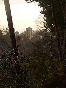
Meyrick Park, Bournemouth
Meyrick Park (/ˈmɛrɪk/) is a suburb and area of Bournemouth, Dorset.[1] The park itself features a main field with rugby pitches, surrounded by elevated woodland on both sides and a golf course around the western side. Dog-walking is permitted on both, and the paved path along the main field is often used to get to the town centre.

History
Meyrick Park was opened in 1894 on previous common land.
In the early 20th century the area was served by Meyrick Park Halt railway station. Cars used to be allowed access along the path by the main field, but this is now restricted.
In 2014, decomposed partial human remains were found in the golf course by a dog who dragged them out the bushes.[2] Police cordoned off the area and discovered a body 40ft up a tree, later revealed to be a man who went missing three years earlier.[3]
Amenities


Meyrick Park has two rugby pitches and a clubhouse overlooking them used by Oakmeadians R.F.C.[4] At the end of the main field there is a bowling green and cafe, and the golf course is served by a country club.[5] The area is just north of St Stephen's Church.
Politics
Meyrick Park is part of the Talbot and Branksome Woods ward for elections to Bournemouth, Christchurch and Poole Council which elects two councillors.
Meyrick Park is part of the Bournemouth East parliamentary constituency.
Notable people
- Richard Palmer-James, musician born in Meyrick Park
References
- "Meyrick Park". Bournemouth. Retrieved 19 November 2020.
- "More human remains found 'high up in a tree' during police search of Meyrick Park golf course". Bournemouth Echo. Retrieved 17 November 2022.
- "Body of man found in tree identified as missing 21-year-old from Bournemouth". Bournemouth Echo. Retrieved 17 November 2022.
- "Oakmeadians RFC Rugby in Bournemouth". Oakmeadians RFC Rugby in Bournemouth. Retrieved 16 November 2022.
- "Health Club, Golf Club and Hotel | Bournemouth | The Club at Meyrick Park". www.theclubatmeyrickpark.com. Retrieved 19 November 2020.

