Microregion of Sudoeste de Goiás
Sudoeste de Goiás Microregion is a region in southwest Goiás state, Brazil. It includes 18 municipalities with a population of 397,387 in a total area of 56,293.30 km2 (21,734.96 sq mi) (2007). The largest towns are Jataí, Santa Helena de Goiás, and Rio Verde. It is watered by several important rivers, which are tributaries of the Paranaíba.
Sudoeste de Goiás | |
|---|---|
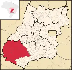 Location in Goias state | |
| Country | Brazil |
| State | Goiás |
| Mesoregion | Sul Goiano |
| Municipalities | 18 |
| Area | |
| • Total | 56,293 km2 (21,735 sq mi) |
| Population (2007) | |
| • Total | 397,387 |
| • Density | 7.1/km2 (18/sq mi) |
This is possibly the richest region of the state of Goiás and is a large producer of soybeans, corn, and cotton. The relatively flat grassy plains are ideal for cattle grazing. Several of the state's most prosperous cities are located here.
The most populous municipality is Rio Verde with 149,3821 inhabitants (2007). The least populous is Aparecida do Rio Doce with 2,702 inhabitants (2007).
The largest municipality in area is Mineiros with 9,096.4 km2. The smallest is Aparecida do Rio Doce with 290 km2.
Municipalities
The microregion consists of the following municipalities:[1]
| Name | Population (2007) |
|---|---|
| Aparecida do Rio Doce | 2,702 |
| Aporé | 3,554 |
| Caiapônia | 15,747 |
| Castelândia | 3,530 |
| Chapadão do Céu | 5,289 |
| Doverlândia | 8,344 |
| Jataí | 81,972 |
| Maurilândia | 10,769 |
| Mineiros | 45,189 |
| Montividiu | 9,255 |
| Palestina de Goiás | 3,229 |
| Perolândia | 2,748 |
| Portelândia | 3,310 |
| Rio Verde | 149,382 |
| Santa Helena de Goiás | 35,027 |
| Santa Rita do Araguaia | 5,873 |
| Santo Antônio da Barra | 4,134 |
| Serranópolis | 7,333 |
References
- Instituto Brasileiro de Geografia e Estatística, territorial division.