Rural City of Mildura
The Rural City of Mildura is a local government area in Victoria, Australia, located in the north-western part of the state. It covers an area of 22,083 square kilometres (8,526 sq mi) being the largest LGA in the state. In August 2021 the area had a population of 56,972.[1] It includes the city of Mildura and the towns of Merbein, Red Cliffs, Irymple, Ouyen, Werrimull, Murrayville, Walpeup and Hattah. It was formed in 1995 from the amalgamation of the City of Mildura, Shire of Mildura and Shire of Walpeup.[2]
| Rural City of Mildura Victoria | |||||||||||||||
|---|---|---|---|---|---|---|---|---|---|---|---|---|---|---|---|
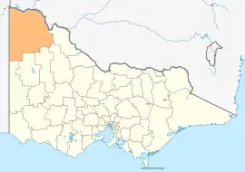 Location in Victoria | |||||||||||||||
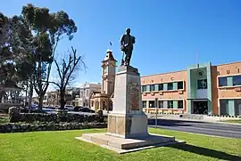 Civic Buildings, 2009 | |||||||||||||||
| Coordinates | 34°47′50″S 141°45′40″E | ||||||||||||||
| Population | 56,972 (2021 census)[1] | ||||||||||||||
| • Density | 2.57990/km2 (6.68192/sq mi) | ||||||||||||||
| Established | 1995 | ||||||||||||||
| Gazetted | 20 January 1995[2] | ||||||||||||||
| Area | 22,083 km2 (8,526.3 sq mi) | ||||||||||||||
| Mayor | Cr Liam Wood | ||||||||||||||
| Council seat | Mildura | ||||||||||||||
| Region | Loddon Mallee | ||||||||||||||
| State electorate(s) | Mildura | ||||||||||||||
| Federal division(s) | Mallee | ||||||||||||||
| Website | Rural City of Mildura | ||||||||||||||
| |||||||||||||||
The Rural City is governed and administered by the Mildura Rural City Council; its seat of local government and administrative centre is located at the council headquarters in Mildura, it also has service centres located in Ouyen and a couple of other locations within Mildura. The Rural City is named after the main urban settlement lying in the north of the LGA, that is Mildura, which is also the LGA's most populous urban centre with a population of 30,647.[3]
The Rural City of Mildura covers most of the Mallee region of Victoria. Before the less infertile soils were fertilised and developed for the production of wheat and barley the whole region was covered in a dense mallee scrub of deep-rooting eucalypts that regenerated after the frequent bushfires in the region. Many of the soils are so sandy that clearing is impractical, and Murray-Sunset National Park covers almost a third of the area of the LGA. Other protected areas include Hattah-Kulkyne National Park and Murray-Kulkyne Park on the Murray River.
The climate of the region is the driest in Victoria, and Neds Corner in the remote northwest has the lowest average annual rainfall in the state at 240 millimetres (9.4 in). In the south at Ouyen the average is 335 mm (13.2 in). In all the areas of the LGA there can be considerable variation in annual rainfall: the range historically has been from 110 mm (4.3 in) in 1967 to 605 mm (23.8 in) in 1973. Temperatures in the LGA are the hottest in Victoria and the average summer maximum is 32 °C (90 °F), but it often exceed 40 °C (104 °F). Winter can be very pleasant with a maximum of 16 °C (61 °F), but frosts are common in the morning and can sometimes be severe.
The southeast of the LGA is used primarily for grain growing; however yield are erratic and often poor due to drought. In the north irrigated fruit growing (primarily oranges and grapes) is highly productive and supports Mildura and nearby towns; however, salinity in the Murray River is a major threat to the long-term sustainability of these activities, as is competition from overseas citrus growers.
In 2006 the Rural City of Mildura had a population of 49,815, most of which was located in Mildura (30,016) and adjacent areas (that is Victorian Sunraysia). Many of the small towns in the region have practically disappeared as more efficient farming methods reduce the quantity of human labour required.
Council
Current composition
The council is composed of nine councillors elected to represent an un-subdivided municipality. Represented in Order of Election.[4] Council Composition as of September 2022:
| Ward | Councillor | Term | Notes | |
|---|---|---|---|---|
| Unsubdivided | Glenn Milne | 2008—Present | ||
| Ian Arney | 2020—Present | |||
| Liam Wood | 2020—Present | Mayor | ||
| Jason Modica | 2016—Present | Deputy Mayor | ||
| Stefano De Pieri | 2020—Present | |||
| Mark Eckel | 2008—Present | |||
| Helen Healy | 2020—Present | |||
| Cyndi Power | 2020—2022 | Resigned 2022 [5] | ||
| Troy Bailey | 2022—Present | Elected by Countback [5] | ||
| Jodi Reynolds | 2020—Present | |||
Administration and governance
The council meets in the council chambers at the council headquarters in the Mildura Municipal Offices, which is also the location of the council's administrative activities. It also provides customer services at both its administrative centre on Madden Avenue in Mildura, and its service centres in Ouyen and on Deakin Avenue in Mildura.[6]
Townships and localities
The 2021 census, the rural city had a population of 56,972 up from 53,878 in the 2016 census[7]
| Population | ||
|---|---|---|
| Locality | 2016 | 2021 |
| Big Desert^ | 3 | 8 |
| Birdwoodton | 643 | 748 |
| Boinka | 13 | 14 |
| Cabarita | 488 | 482 |
| Cardross | 821 | 847 |
| Carina | 22 | 26 |
| Carwarp | 70 | 68 |
| Colignan | 329 | 305 |
| Cowangie | 36 | 33 |
| Cullulleraine | 69 | 81 |
| Hattah | 28 | 27 |
| Population | ||
|---|---|---|
| Locality | 2016 | 2021 |
| Iraak | 128 | 118 |
| Irymple | 5,325 | 5,977 |
| Koorlong | 366 | 397 |
| Kulwin | 15 | 16 |
| Lindsay Point | 38 | 32 |
| Linga | 10 | 13 |
| Merbein | 2,713 | 2,770 |
| Merbein South | 405 | 407 |
| Merbein West | 190 | 223 |
| Meringur | 67 | 70 |
| Population | ||
|---|---|---|
| Locality | 2016 | 2021 |
| Merrinee | 48 | 42 |
| Mildura | 32,738 | 34,565 |
| Mittyack | 14 | 12 |
| Murray-sunset | 4 | 8 |
| Murrayville | 280 | 278 |
| Nangiloc | 141 | 153 |
| Neds Corner | 4 | 3 |
| Nichols Point | 1,551 | 1,723 |
| Ouyen | 1,191 | 1,170 |
| Panitya | 65 | 67 |
| Population | ||
|---|---|---|
| Locality | 2016 | 2021 |
| Patchewollock^ | 133 | 149 |
| Red Cliffs | 5,060 | 5,294 |
| Tempy^ | 57 | 62 |
| Torrita | 32 | 51 |
| Tutye | 20 | 21 |
| Underbool | 215 | 215 |
| Walpeup | 158 | 171 |
| Wargan | 71 | 53 |
| Werrimull | 112 | 97 |
| Yelta | 322 | 325 |
^ - Territory divided with another LGA
Sister cities
Mildura has sister city relations with the following cities:[8]
- Dali, Yunnan Province of China
- Kumatori, Japan
- Upland, California, United States of America
Notes
References
- Australian Bureau of Statistics (28 June 2022). "City of Mildura (Local Government Area)". 2021 Census QuickStats. Retrieved 15 April 2023.
- Victoria Government Gazette – Online Archive (1837–1997). "S4 of 1995: Order estg (Part 10) the Rural City of Mildura". State Library of Victoria. State Government of Victoria (published 20 January 1995). p. 4. Retrieved 10 January 2014.
- Census QuickStats (2011). "Mildura (SS) – SSC20893". Australian Bureau of Statistics. Government of Australia. Retrieved 10 January 2014.
- "Mildura Rural City Council election results 2020". Victorian Electoral Commission. 2020. Retrieved 14 September 2022.
- "Council Elections". Mildura Rural City Council. 2022. Retrieved 14 September 2022.
- "Our Councillors". www.mildura.vic.gov.au. Retrieved 9 February 2021.
- "Census | Australian Bureau of Statistics". www.abs.gov.au. 11 January 2023.
- Mildura Rural City Council. "Sister Cities". Mildura Rural City Council. Archived from the original on 28 November 2013. Retrieved 12 December 2013.
External links
![]() Media related to Rural City of Mildura at Wikimedia Commons
Media related to Rural City of Mildura at Wikimedia Commons
- Mildura Rural City Council
- Metlink local public transport map
- Link to Land Victoria interactive maps
Localities in the Rural City of Mildura | ||
|---|---|---|
| City |  | |
| Town | ||
| Locality | ||
^ - Territory divided with another LGA | ||