Mill Creek (Whitelock Creek tributary)
Mill Creek is a tributary of Whitelock Creek in Wyoming County, Pennsylvania, in the United States. It is approximately 4.7 miles (7.6 km) long and flows through Northmoreland Township and Exeter Township.[1] The watershed of the creek has an area of 3.77 square miles (9.8 km2). The surficial geology in its vicinity consists mainly of alluvium, Wisconsinan Till, bedrock, Wisconsinan Ice-Contact Stratified Drift, and loess.
| Mill Creek | |
|---|---|
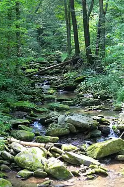 Mill Creek looking upstream | |
| Physical characteristics | |
| Source | |
| • location | unnamed lake in Northmoreland Township, Wyoming County, Pennsylvania |
| • elevation | between 1,120 and 1,140 feet (341 and 347 m) |
| Mouth | |
• location | Susquehanna River in Exeter Township, Wyoming County, Pennsylvania |
• coordinates | 41°26′26″N 75°51′34″W |
• elevation | 577 ft (176 m) |
| Length | 4.7 mi (7.6 km) |
| Basin size | 3.77 sq mi (9.8 km2) |
| Basin features | |
| Progression | Whitelock Creek → Susquehanna River → Chesapeake Bay |
Course
Mill Creek begins in an unnamed lake in Northmoreland Township. It flows east-southeast for a short distance before turning east-northeast and flowing into a valley. After several tenths of a mile, the creek turns east for several tenths of a mile before turning northeast for several tenths of a mile and passing through a pond or small lake. It then turns southeast for several tenths of a mile before turning east for a short distance and then turning northeast. A few tenths of a mile further downstream, the creek turns northeast for a short distance before gradually turning east and then south. After several tenths of a mile, it crosses Pennsylvania Route 292 and reaches its confluence with Whitelock Creek.[1]
Mill Creek joins Whitelock Creek 0.28 miles (0.45 km) upstream of its mouth.[2]
Geography and geology
The elevation near the mouth of Mill Creek is 577 feet (176 m) above sea level.[3] The elevation of the creek's source is between 1,120 and 1,140 feet (341 and 347 m) above sea level.[1]
The surficial geology near the mouth of Mill Creek mainly consists of alluvium and Wisconsinan Ice-Contact Stratified Drift. However, slightly further upstream, Wisconsinan Till dominates.[4] Alluvium again occurs along the creek in its middle and upper reaches, although larger Wisconsinan Till and bedrock consisting of sandstone and shale occur nearby. There are also a few patches of loess, which contains silt and fine sand.[5]
There is a pipeline in the watershed of Mill Creek. In 2013, this pipeline was found to violate the Clean Streams Law.[6] Mill Creek has been one of the receiving streams for Williams Field Services Company, LLC's erosion and sediment control permit.[7]
Watershed
The watershed of Mill Creek has an area of 3.77 square miles (9.8 km2).[2] The mouth of the creek is in the United States Geological Survey quadrangle of Ransom. However, its source is in the quadrangle of Center Moreland.[3]
History
Mill Creek was entered into the Geographic Names Information System on August 2, 1979. Its identifier in the Geographic Names Information System is 1199158.[3]
A concrete stringer/multi-beam or girder bridge carrying State Route 2002 was built over Mill Creek in 1930. It is 24.9 feet (7.6 m) long and is in Exeter Township.[8]
Biology
Wild trout naturally reproduce in Mill Creek from its headwaters downstream to its mouth.[9] The creek is designated as a Coldwater Fishery.[6]
See also
References
- United States Geological Survey, The National Map Viewer, archived from the original on March 29, 2012, retrieved September 4, 2015
- Pennsylvania Gazetteer of Streams (PDF), November 2, 2001, pp. 99, 150, retrieved September 4, 2015
- Geographic Names Information System, Feature Detail Report for: Mill Creek, retrieved September 4, 2015
- Duane D. Braun, Surficial geology of the Ransom 7.5-minute quadrangle, Lackawanna, Wyoming, and Luzerne Counties, Pennsylvania, p. 14, archived from the original on May 24, 2014, retrieved September 4, 2015
- Duane D. Braun, Surficial geology of the Center Moreland 7.5-minute quadrangle, Wyoming and Luzerne Counties, Pennsylvania, p. 15, archived from the original on May 24, 2014, retrieved September 4, 2015
- Commonwealth of Pennsylvania, Pennsylvania Department of Environmental Protection (April 5, 2013), Consent Assessment of Civil Penalty (PDF), pp. 1–2, retrieved September 4, 2015
- "EROSION AND SEDIMENT CONTROL", Pennsylvania Bulletin, January 5, 2013, retrieved September 4, 2015
- Wyoming County, retrieved September 4, 2015
- Pennsylvania Fish and Boat Commission (August 2015), Pennsylvania Wild Trout Waters (Natural Reproduction) - August 2015 (PDF), p. 106, retrieved September 4, 2015