Shire of Moira
Moira Shire Council is a Local Government Area in the Northern Victoria Region of Victoria, Australia. Located in the north-east part of the state, it covers an area of 4,045 square kilometres (1,562 sq mi). As at June 2021 the population was 30,018.[1]
| Moira Shire Council Victoria | |||||||||||||||
|---|---|---|---|---|---|---|---|---|---|---|---|---|---|---|---|
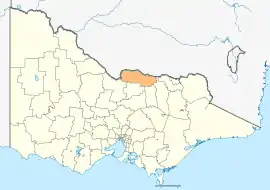 Location in Victoria | |||||||||||||||
| Population | 30,018 (2021)[1] | ||||||||||||||
| • Density | 7.4210/km2 (19.2203/sq mi) | ||||||||||||||
| Established | 1994 | ||||||||||||||
| Gazetted | 18 November 1994[2] | ||||||||||||||
| Area | 4,045 km2 (1,561.8 sq mi)[1] | ||||||||||||||
| Council seat | Cobram | ||||||||||||||
| Region | Hume | ||||||||||||||
| State electorate(s) | |||||||||||||||
| Federal division(s) | Nicholls | ||||||||||||||
| Website | Moira Shire Council | ||||||||||||||
| |||||||||||||||
It includes the towns of Cobram, Nathalia, Numurkah, Tungamah and Yarrawonga. It was formed in 1994 from the amalgamation of the Shire of Cobram, Shire of Nathalia, Shire of Numurkah, and parts of the Shire of Tungamah and Shire of Yarrawonga.[2]
The Shire is governed and administered by the Moira Shire Council; its seat of local government and administrative centre is located at the council headquarters in Cobram, it also has a service centre located in Yarrawonga. The Shire is named after the county of Moira, of which the LGA occupies the northern part.
Council
Current composition
The council is composed of nine councillors elected to represent an unsubdivided municipality.[3]
In the wake of a report detailing the "preventable" murder of a senior manager, the Moira Shire council was dismissed by the Minister for Local Government, Melissa Horne on 7 March 2023. An interim administrator has been appointed. [4] Elections to elect a new council will not be held until 2028.[5]
Administration and governance
The council meets in various locations around the Shire. It also provides customer services at both its administrative centre in Cobram and its service centre in Yarrawonga.
Townships and localities
The 2021 census, the shire had a population of 30,522 up from 29,112 in the 2016 census[6]
| Population | ||
|---|---|---|
| Locality | 2016 | 2021 |
| Almonds | 26 | 31 |
| Barmah | 282 | 229 |
| Bathumi | 62 | 76 |
| Bearii | 145 | 167 |
| Boomahnoomoonah | 22 | 14 |
| Boosey | 105 | 108 |
| Boweya North | 43 | 42 |
| Bundalong | 428 | 512 |
| Bundalong South | 51 | 42 |
| Burramine | 197 | 241 |
| Burramine South | 24 | 24 |
| Cobram | 6,014 | 6,148 |
| Cobram East | 242 | 232 |
| Drumanure | 41 | 41 |
| Population | ||
|---|---|---|
| Locality | 2016 | 2021 |
| Esmond | 9 | 17 |
| Invergordon | 610 | 601 |
| Kaarimba | 85 | 93 |
| Katamatite | 401 | 453 |
| Katamatite East | 35 | 30 |
| Katunga | 996 | 1,025 |
| Koonoomoo | 296 | 305 |
| Kotupna | 105 | 132 |
| Lake Rowan | 66 | 70 |
| Lower Moira | 25 | 30 |
| Marungi^ | 111 | 98 |
| Muckatah | 213 | 170 |
| Mundoona | 119 | 138 |
| Mywee | 14 | 20 |
| Population | ||
|---|---|---|
| Locality | 2016 | 2021 |
| Naring | 120 | 122 |
| Nathalia | 1,880 | 1,982 |
| Numurkah | 4,477 | 4,604 |
| Peechelba^ | 184 | 177 |
| Pelluebla | 33 | 29 |
| Picola | 207 | 206 |
| Picola West | 9 | 14 |
| St James | 132 | 123 |
| Strathmerton | 1,052 | 1,072 |
| Telford | 24 | 21 |
| Tungamah | 408 | 449 |
| Ulupna | 23 | 17 |
| Waaia | 390 | 420 |
| Population | ||
|---|---|---|
| Locality | 2016 | 2021 |
| Waggarandall | 40 | 52 |
| Wilby | 166 | 192 |
| Wunghnu | 334 | 326 |
| Yabba North | 101 | 104 |
| Yabba South | 27 | 32 |
| Yalca | 206 | 222 |
| Yarrawonga | 7,930 | 8,661 |
| Yarrawonga South | 15 | 15 |
| Yarroweyah | 548 | 551 |
| Yielima | 87 | 93 |
| Youanmite | 59 | 56 |
| Youarang | 39 | 34 |
| Yundool | 44 | 52 |
^ - Territory divided with another LGA
See also
References
- "Moira Shire Council Annual Report 2020/21" (PDF). Moira Shire Council. 30 June 2021. Retrieved 27 November 2021.
- Victoria Government Gazette – Online Archive (1837–1997). "S87 of 1994: Order estg (Part 11) the Shire of Moira". State Library of Victoria. State Government of Victoria (published 18 November 1994). p. 4. Retrieved 10 January 2014.
- Local Government in Victoria. "Moira Shire Council". Department of Transport, Planning and Local Infrastructure. State Government of Victoria. Retrieved 10 January 2014.
- Ilanbey, Benjamin Preiss, Sumeyya (7 March 2023). "'Catastrophic event': Moira council sacked after employee murder". Brisbane Times.
{{cite web}}: CS1 maint: multiple names: authors list (link) - Preiss, Benjamin; Illanbey, Sumeyya (7 March 2023). "'Extremely toxic atmosphere': Moira council sacked after employee murder". The Age. Retrieved 7 March 2023.
- "Census | Australian Bureau of Statistics". www.abs.gov.au. 11 January 2023.
External links
 Media related to Shire of Moira at Wikimedia Commons
- Moira Shire Council official website
- Metlink local public transport map
- Link to Land Victoria interactive maps
Localities in the Shire of Moira | ||
|---|---|---|
| Town | ||
| Locality |
| |
^ - Territory divided with another LGA | ||