Moka District
Moka (Mauritian Creole pronunciation: [moka]) is a district of Mauritius, situated in the central plateau of the island. The district has an area of 230.5 km2 and the population estimate was at 83,664 as at the end of 2019.[2]
Moka | |
|---|---|
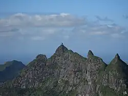 Pieter Both of the Moka Range | |
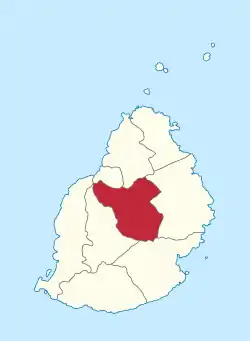 Map of Mauritius island with Moka District highlighted | |
| Coordinates: 20°15′S 57°34′E | |
| Country | |
| Government | |
| • Type | District Council |
| • Chairman | Soonarane Kumar |
| • Vice Chairman | Ramduny Vageesh |
| Area | |
| • Total | 230.5 km2 (89.0 sq mi) |
| Population (2019)[2] | |
| • Total | 83,664 |
| • Rank | 7th in Mauritius |
| • Density | 360/km2 (940/sq mi) |
| Time zone | UTC+4 (MUT) |
| ISO 3166 code | MU-MO (Moka) |
| Website | www |
History
Places of interest
bagatelle mall,
Places
The Moka District includes different regions; however, some regions are further divided into different suburbs.[3] Note that the statistics do not take into account that Ripailles was created out of Nouvelle Découverte and that Pailes was absorbed by Port-Louis Municipal Council in 2011 following the new Local Government Act.[4]
Places by population
| Places by population, area and density | |||
|---|---|---|---|
| Place | Population[5] | Area in km²[6] | Population density per km²[6] |
| Camp Thorel | 2,128 | 12.77 | 166.6 |
| Dagotière | 7,146 | 10.7 | 667.9 |
| Dubreuil (East in Flacq District) | 2,840 | 80 | 35.5 |
| Espérance | 1,884 | 7.64 | 246.6 |
| La Laura - Malenga | 1,288 | 4.87 | 264.5 |
| L'Avenir | 2,701 | 8.42 | 320.8 |
| Melrose | 1,955 | 4.39 | 445.3 |
| Moka (West in Plaines Wilhems district) | 8,846 | 17.44 | 507.2 |
| Montagne Blanche (East in Flacq District) | 9,053 | 19.63 | 461.2 |
| Pailles | 11,618 | 14.62 | 794.7 |
| Providence | 3,285 | 3.72 | 883.1 |
| Quartier Militaire | 7,046 | 6.89 | 1,022.6 |
| Nouvelle Découverte | 3,024 | 22.04 | 137.2 |
| St Pierre | 15,982 | 13.06 | 1,223.7 |
| Verdun | 2,181 | 4.15 | 525.5 |
Education
French international schools:
- Lycée des Mascareignes - Senior high/Sixth form[7]
- École du Centre/Collège Pierre-Poivre - Primary and junior high school[8][9]
See also
Wikimedia Commons has media related to Moka District.
References
- "Portal of Local Authorities, Mauritius". Retrieved 8 March 2014.
- "Table 1.6(b) - Estimated resident population1 by geographical district, sex and density - Republic of Mauritius2, 2018 & 2019". Annual Digest of Statistics 2019 (XLS). Statistics Mauritius. November 2020.
- Housing and population Census 2011 (PDF). Statistics Mauritius. 2011. Retrieved 12 September 2012.
- "MUNICIPALES: Toilettage des registres d'électeurs | le Mauricien". Archived from the original on 14 July 2014. Retrieved 24 July 2014.
- "Table D2 - Resident population by geographical location, age and sex". 2011 Housing and Population Census (PDF). Vol. II: Demographic and Fertility Characteristics. Statistics Mauritius. October 2012. p. 51.
- "Table G5 - Concentration of resident population by Municipal and Village Council Areas". 2011 Housing and Population Census (PDF). Vol. VI: Geographical and migration characteristics. October 2012. pp. 27–31.
- "Nous contacter Archived 1 June 2013 at the Wayback Machine." Lycée des Mascareignes. Retrieved on Mar 4, 2015. "Helvetia Saint Pierre Ile MAURICE "
- "École du Centre - Collège Pierre-Poivre." AEFE. Retrieved on May 4, 2015.
- Home page. École du Centre - Collège Pierre-Poivre. Retrieved on 4 May 2015.
| Subdivisions |
| .svg.png.webp) | ||||||||||||
|---|---|---|---|---|---|---|---|---|---|---|---|---|---|---|
| Politics | ||||||||||||||
| Economy | ||||||||||||||
| Society |
| |||||||||||||
This article is issued from Wikipedia. The text is licensed under Creative Commons - Attribution - Sharealike. Additional terms may apply for the media files.