Mongolian Plateau
The Mongolian Plateau is the part of the Central Asian Plateau lying between 37°46′-53°08′N and 87°40′-122°15′E and having an area of approximately 3,200,000 square kilometres (1,200,000 sq mi). It is bounded by the Greater Hinggan Mountains in the east, the Yin Mountains to the south, the Altai Mountains to the west, and the Sayan and Khentii mountains to the north.[1] The plateau includes the Gobi Desert as well as dry steppe regions. It has an elevation of roughly 1,000 to 1,500 meters, with the lowest point in Hulunbuir and the highest point in the Altai.[1]
| Mongolian Plateau | |||||||||
|---|---|---|---|---|---|---|---|---|---|
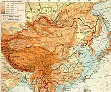
 1903 topographic map of the Qing dynasty depicting the Mongolian Plateau | |||||||||
| Chinese name | |||||||||
| Traditional Chinese | 蒙古高原 | ||||||||
| Simplified Chinese | 蒙古高原 | ||||||||
| |||||||||
| Mongolian name | |||||||||
| Mongolian Cyrillic | Монголын тэгш өндөрлөг | ||||||||
| Mongolian script | ᠮᠣᠩᠭᠣᠯ ᠤᠨ ᠲᠡᠭᠰᠢ ᠥᠨᠳᠥᠷᠯᠢᠭ | ||||||||
Politically, the plateau spans all of Mongolia, along with parts of China and Russia. Inner Mongolia and parts of the Dzungarian basin in Xinjiang encompass the Chinese portion of the plateau. In Russia, the plateau forms Transbaikal, part of Buryatia, and the southern Irkutsk Oblast. The Mongolian Plateau comprises the majority of the area known as the Mongol heartland.
History
The plateau was inhabited and conquered by various groups, including (chronologically) the Xiongnu, Xianbei, Göktürks, Tang dynasty, Liao dynasty, Mongol Empire, Yuan dynasty, Northern Yuan dynasty, and Qing dynasty.
Changing environment
Between 1980 and 2010, rising global temperatures and direct human activity (particularly the use of lake water for mining and agriculture) have contributed to a significant loss of lake surface area across the Plateau. Qagaan Nurr and XinKai Lake have shrunk by two-thirds of their surface area during that time, while others (including [[Huangqihai Lake]] and Naiman Xihu) have dried up entirely. Some exceptions, such as East Juyan Lake and Had Paozi, have grown, but overall the average total surface area of lakes in the region has shrunk by 30%.[2][3]
References
- Zhang, Xueyan; Hu, Yunfeng; Zhuang, Dafang; Qi, Yongqing; Ma, Xin (2009). "NDVI spatial pattern and its differentiation on the Mongolian Plateau". Journal of Geographical Sciences. Springer-Verlag. 19 (4): 405. doi:10.1007/s11442-009-0403-7.
- "Shrinking Lakes on the Mongolian Plateau". NASA. 8 April 2015. Retrieved 26 November 2016.
- Tao, Shengli; Fang, Jingyun; Zhao, Xia; Zhao, Shuqing; Shen, Haihua; Hu, Huifeng; Tang, Zhiyao; Wang, Zhiheng; Guo, Qinghua (17 February 2015). "Rapid loss of lakes on the Mongolian Plateau". Proceedings of the National Academy of Sciences. 112 (7): 2281–2286. doi:10.1073/pnas.1411748112. PMC 4343146. PMID 25646423.
External links
- John, Ranjeet; et al. (2013). "Vegetation response to extreme climate events on the Mongolian Plateau from 2000 to 2010". Environmental Research Letters. IOP Publishing. 8 (3): 035033. doi:10.1088/1748-9326/8/3/035033.
- "Mongolian Plateau region, Mongolia and China". Britannica.com. Encyclopædia Britannica. 2 August 1999. Retrieved 26 November 2016.