Mont Albert railway station
Mont Albert railway station was located on the Lilydale and Belgrave lines in Victoria, Australia, serving the eastern Melbourne suburb of Mont Albert. Located between Surrey Hills and Box Hill, it opened on 11 August 1890 and closed on 17 February 2023, due to project works associated with the Level Crossing Removal Project.[5]
Mont Albert | |||||||||||||||||||||||||||||||||||||||||||||||||||||||||||||||||||||||||
|---|---|---|---|---|---|---|---|---|---|---|---|---|---|---|---|---|---|---|---|---|---|---|---|---|---|---|---|---|---|---|---|---|---|---|---|---|---|---|---|---|---|---|---|---|---|---|---|---|---|---|---|---|---|---|---|---|---|---|---|---|---|---|---|---|---|---|---|---|---|---|---|---|---|
| Closed PTV commuter rail station | |||||||||||||||||||||||||||||||||||||||||||||||||||||||||||||||||||||||||
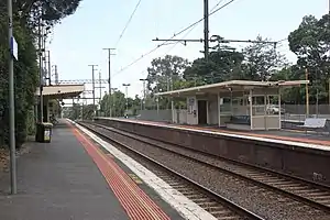
 Westbound view from Platform 1 in January 2016 | |||||||||||||||||||||||||||||||||||||||||||||||||||||||||||||||||||||||||
| General information | |||||||||||||||||||||||||||||||||||||||||||||||||||||||||||||||||||||||||
| Location | Churchill Street, Mont Albert, Victoria Australia | ||||||||||||||||||||||||||||||||||||||||||||||||||||||||||||||||||||||||
| Coordinates | 37°49′10″S 145°06′20″E | ||||||||||||||||||||||||||||||||||||||||||||||||||||||||||||||||||||||||
| Owned by | VicTrack | ||||||||||||||||||||||||||||||||||||||||||||||||||||||||||||||||||||||||
| Operated by | Metro Trains | ||||||||||||||||||||||||||||||||||||||||||||||||||||||||||||||||||||||||
| Line(s) | |||||||||||||||||||||||||||||||||||||||||||||||||||||||||||||||||||||||||
| Distance | 14.63 kilometres from Southern Cross | ||||||||||||||||||||||||||||||||||||||||||||||||||||||||||||||||||||||||
| Platforms | 3 (1 island, 1 side) | ||||||||||||||||||||||||||||||||||||||||||||||||||||||||||||||||||||||||
| Tracks | 3 | ||||||||||||||||||||||||||||||||||||||||||||||||||||||||||||||||||||||||
| Connections | |||||||||||||||||||||||||||||||||||||||||||||||||||||||||||||||||||||||||
| Construction | |||||||||||||||||||||||||||||||||||||||||||||||||||||||||||||||||||||||||
| Structure type | Ground | ||||||||||||||||||||||||||||||||||||||||||||||||||||||||||||||||||||||||
| Parking | 30 | ||||||||||||||||||||||||||||||||||||||||||||||||||||||||||||||||||||||||
| Bicycle facilities | Yes | ||||||||||||||||||||||||||||||||||||||||||||||||||||||||||||||||||||||||
| Accessible | Yes | ||||||||||||||||||||||||||||||||||||||||||||||||||||||||||||||||||||||||
| Other information | |||||||||||||||||||||||||||||||||||||||||||||||||||||||||||||||||||||||||
| Status | Demolished (Platform 1 station building retained for community purposes)[1] | ||||||||||||||||||||||||||||||||||||||||||||||||||||||||||||||||||||||||
| Station code | MAB | ||||||||||||||||||||||||||||||||||||||||||||||||||||||||||||||||||||||||
| Fare zone | Myki Zone 1/2 overlap | ||||||||||||||||||||||||||||||||||||||||||||||||||||||||||||||||||||||||
| Website | Public Transport Victoria | ||||||||||||||||||||||||||||||||||||||||||||||||||||||||||||||||||||||||
| History | |||||||||||||||||||||||||||||||||||||||||||||||||||||||||||||||||||||||||
| Opened | 11 August 1890 | ||||||||||||||||||||||||||||||||||||||||||||||||||||||||||||||||||||||||
| Closed | 17 February 2023 | ||||||||||||||||||||||||||||||||||||||||||||||||||||||||||||||||||||||||
| Rebuilt | 19 December 1971 | ||||||||||||||||||||||||||||||||||||||||||||||||||||||||||||||||||||||||
| Electrified | December 1922 (1500 V DC overhead) | ||||||||||||||||||||||||||||||||||||||||||||||||||||||||||||||||||||||||
| Passengers | |||||||||||||||||||||||||||||||||||||||||||||||||||||||||||||||||||||||||
| 2005–2006 | 276,139[2] | ||||||||||||||||||||||||||||||||||||||||||||||||||||||||||||||||||||||||
| 2006–2007 | 308,542[2] | ||||||||||||||||||||||||||||||||||||||||||||||||||||||||||||||||||||||||
| 2007–2008 | 331,424[2] | ||||||||||||||||||||||||||||||||||||||||||||||||||||||||||||||||||||||||
| 2008–2009 | 354,074[3] | ||||||||||||||||||||||||||||||||||||||||||||||||||||||||||||||||||||||||
| 2009–2010 | 368,458[3] | ||||||||||||||||||||||||||||||||||||||||||||||||||||||||||||||||||||||||
| 2010–2011 | 353,325[3] | ||||||||||||||||||||||||||||||||||||||||||||||||||||||||||||||||||||||||
| 2011–2012 | 315,978[3] | ||||||||||||||||||||||||||||||||||||||||||||||||||||||||||||||||||||||||
| 2012–2013 | Not measured[3] | ||||||||||||||||||||||||||||||||||||||||||||||||||||||||||||||||||||||||
| 2013–2014 | 323,005[3] | ||||||||||||||||||||||||||||||||||||||||||||||||||||||||||||||||||||||||
| 2014–2015 | 291,184[2] | ||||||||||||||||||||||||||||||||||||||||||||||||||||||||||||||||||||||||
| 2015–2016 | 270,334[3] | ||||||||||||||||||||||||||||||||||||||||||||||||||||||||||||||||||||||||
| 2016–2017 | 268,495[3] | ||||||||||||||||||||||||||||||||||||||||||||||||||||||||||||||||||||||||
| 2017–2018 | 253,964[3] | ||||||||||||||||||||||||||||||||||||||||||||||||||||||||||||||||||||||||
| 2018–2019 | 260,854[3] | ||||||||||||||||||||||||||||||||||||||||||||||||||||||||||||||||||||||||
| 2019–2020 | 200,300[3] | ||||||||||||||||||||||||||||||||||||||||||||||||||||||||||||||||||||||||
| 2020–2021 | 84,300[3] | ||||||||||||||||||||||||||||||||||||||||||||||||||||||||||||||||||||||||
| 2021–2022 | 98,450[4] | ||||||||||||||||||||||||||||||||||||||||||||||||||||||||||||||||||||||||
| Former services | |||||||||||||||||||||||||||||||||||||||||||||||||||||||||||||||||||||||||
| |||||||||||||||||||||||||||||||||||||||||||||||||||||||||||||||||||||||||
| |||||||||||||||||||||||||||||||||||||||||||||||||||||||||||||||||||||||||
History
Mont Albert station opened on 11 August 1890 and, like the suburb itself, was named after Prince Albert, the consort of Queen Victoria.[6]
In 1963, boom barriers replaced hand gates at the former Mont Albert Road level crossing, which was located nearby in the Flinders Street (up) direction of the station.[7]
In the 1960s, track amplification works resulted in the Box Hill-bound platform being rebuilt and converted to an island platform.[8] In December 1971, services on the third track from East Camberwell were extended though the station to Box Hill.[9]
In 2020, it was announced that the level crossings at Union and Mont Albert Roads would be fast-tracked for removal by 2023.[1] The project will involve the closure of both Mont Albert and nearby Surrey Hills, with a brand new station, named Union, to be constructed between the two stations. The current station building on Platform 1 is to be refurbished and relocated within the precinct for community use.[1][10]
On 17 February 2023, the last train to depart from Mont Albert was a Belgrave-bound train at 20:37.[5] The station was permanently closed soon after for demolition, alongside Surrey Hills. The replacement new station, Union, opened on 22 May of that year.[11]
Platforms and services
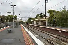
Mont Albert had one island platform (Platforms 2 and 3) and one side platform (Platform 1), linked by an underpass. It was serviced by Metro Trains' Lilydale and Belgrave line services.[12][13]
Platform 1:
- Lilydale line all stations and limited express services to Flinders Street
- Belgrave line all stations and limited express services to Flinders Street
Platform 2:
- Lilydale line all stations services to Lilydale
- Belgrave line all stations services to Belgrave
Platform 3:
- Lilydale line weekday all stations services to Blackburn, Ringwood and Lilydale
- Belgrave line weekday all stations services to Blackburn, Ringwood and Belgrave
Transport links
At the time of closure, one bus route serviced Mont Albert, under contract to Public Transport Victoria:
- 766 : Box Hill station - Burwood (operated by Ventura Bus Lines)[14]
Gallery
 Eastbound view from Platform 2 in May 2014
References
- "Surrey Hills and Mont Albert crossings removal fast-tracked". Victoria's Big Build. Archived from the original on 29 April 2023. Retrieved 29 April 2023.
- Estimated Annual Patronage by Network Segment Financial Year 2005-2006 to 2018-19 Archived 17 April 2022 at the Wayback Machine Department of Transport
- Railway station and tram stop patronage in Victoria for 2008-2021 Archived 17 December 2022 at the Wayback Machine Philip Mallis
- Annual metropolitan train station patronage (station entries) Archived 6 March 2023 at the Wayback Machine Data Vic
- "Mont Albert". vicsig.net. Archived from the original on 29 April 2023. Retrieved 29 April 2023.
- "Mont Albert". Victorian Places. Archived from the original on 5 January 2023. Retrieved 5 January 2023.
- "Lights and Barriers for Crossings". The Age. 18 April 1963. p. 5.
- "Victorian Railways: East Camberwell to Box Hill diagram 5' 30". signaldiagramsandphotos.com. Retrieved 11 March 2008.
- SE Dornan & RG Henderson (1979). Electric Railways of Victoria. Australian Electric Traction Society. p. 80. ISBN 0-909459-06-1.
- Surrey Hills level crossing removal Archived 16 January 2023 at the Wayback Machine City of Boroondara
- "New Union Station to open on 22 May". Victoria's Big Build. Archived from the original on 29 April 2023. Retrieved 29 April 2023.
- "Lilydale Line". Public Transport Victoria.
- "Belgrave Line". Public Transport Victoria.
- "766 Box Hill - Burwood via Surrey Hills". Public Transport Victoria. Retrieved 29 April 2023.
External links
- Melway map at street-directory.com.au